


The laces of the Monte Carlo Rally
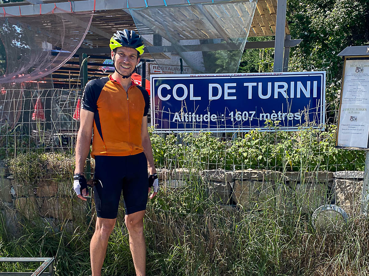
Altitude 1604 m
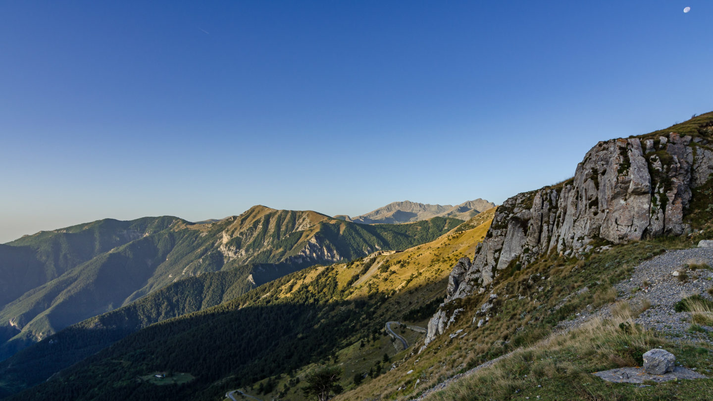
Massifs des Préalpes de Nice
Département Alpes-Maritimes
Summary
- Plan your bike ascent of the Col de Turini
- Bike up the Col de Turini from the Vésubie valley, by the west side
- Description of the ascent of the Col de Turini from the Vésubie valley, by the west side
- Bicycling up the Col de Turini from Sospel, by the south side
- Description of the ascent of the Col de Turini by bicycle from Sospel, by the south side
- Tips for preparing to climb the col de Turini
- Weather conditions for the col de Turini
- Recommended equipment for the col de Turini
- Services at the col de Turini
- Access to Turini pass
- Témoignages
- FAQ
Plan your cycling ascent of the Col de Turini
Located at an altitude of 1604 m in the Préalpes de Nice massif, this col sur Route des Grandes Alpes ® and inland Nice owes its fame to the Monte Carlo Rally. With your brand-new bike and a champion's training, you won't need a big engine to enjoy the twists and turns that have made its reputation. Note that a multitude of roads, representing as many variants, cross and intersect at the summit of the Turini.
Cycling up the Col de Turini from the Vésubie valley, via the western slope
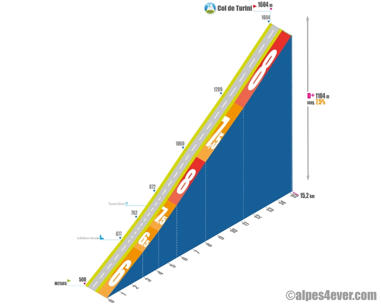 Start: route départementale 2565, in the Vésubie valley (500 m)
Distance: 15.2 km
Altitude: 1604 m
Vertical rise: 1104 m
Average gradient: 7.2%
Maximum gradient: 9%
Tour de France® rating: hors catégorie
Time to climb (rounded) the Col de Turini by bike from the Vésubie valley, via the west side
- At 7 km/h: > 2 h 00
- At 11 km/h: 1 h 20
- At 15 km/h : 1 h 00
- At 19 km/h : < 50'
Map of the route up the Col de Turini by bike from the Vésubie valley, via the west side
Description of the ascent of the Col de Turini by bike from the Vésubie valley, by the west side
Our friend Joris Lesueur, indefatigable pass hunter and tireless host of the alpes4 ever website, has counted eight variants, offering between 1104 m and 1544 m of positive ascent. We've chosen two of them, leaving you the pleasure of discovering the others for yourself!
Let's start with the "normal route": some fifteen kilometers from the bottom of the Vésubie valley (junction with the departmental road 2565), passing through the beautiful perched village of La Bollène-Vésubie. 1104 D+ for an average gradient of almost 7.5%. Start early if it's hot!
The start, between the junction with the M2565 and La Bollène-Vésubie, isn't very difficult: 6% for around 3 kilometers. Add another kilometer at 6.5% and prepare to suffer.
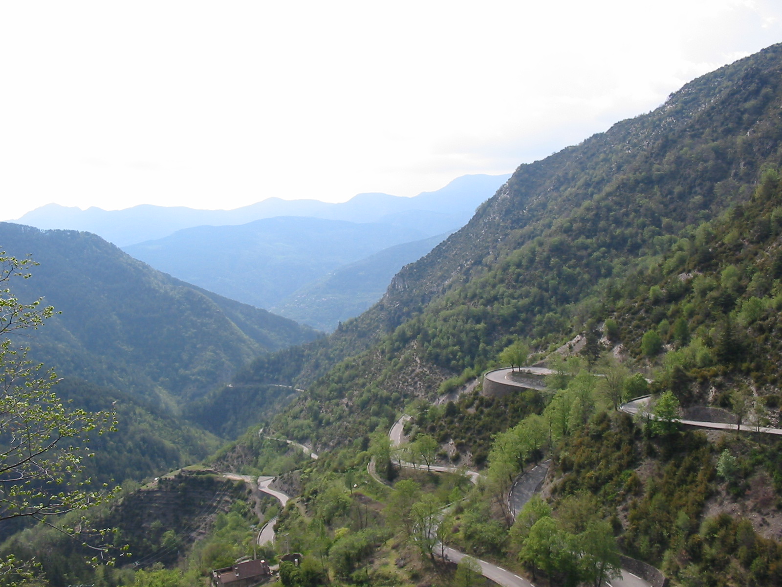
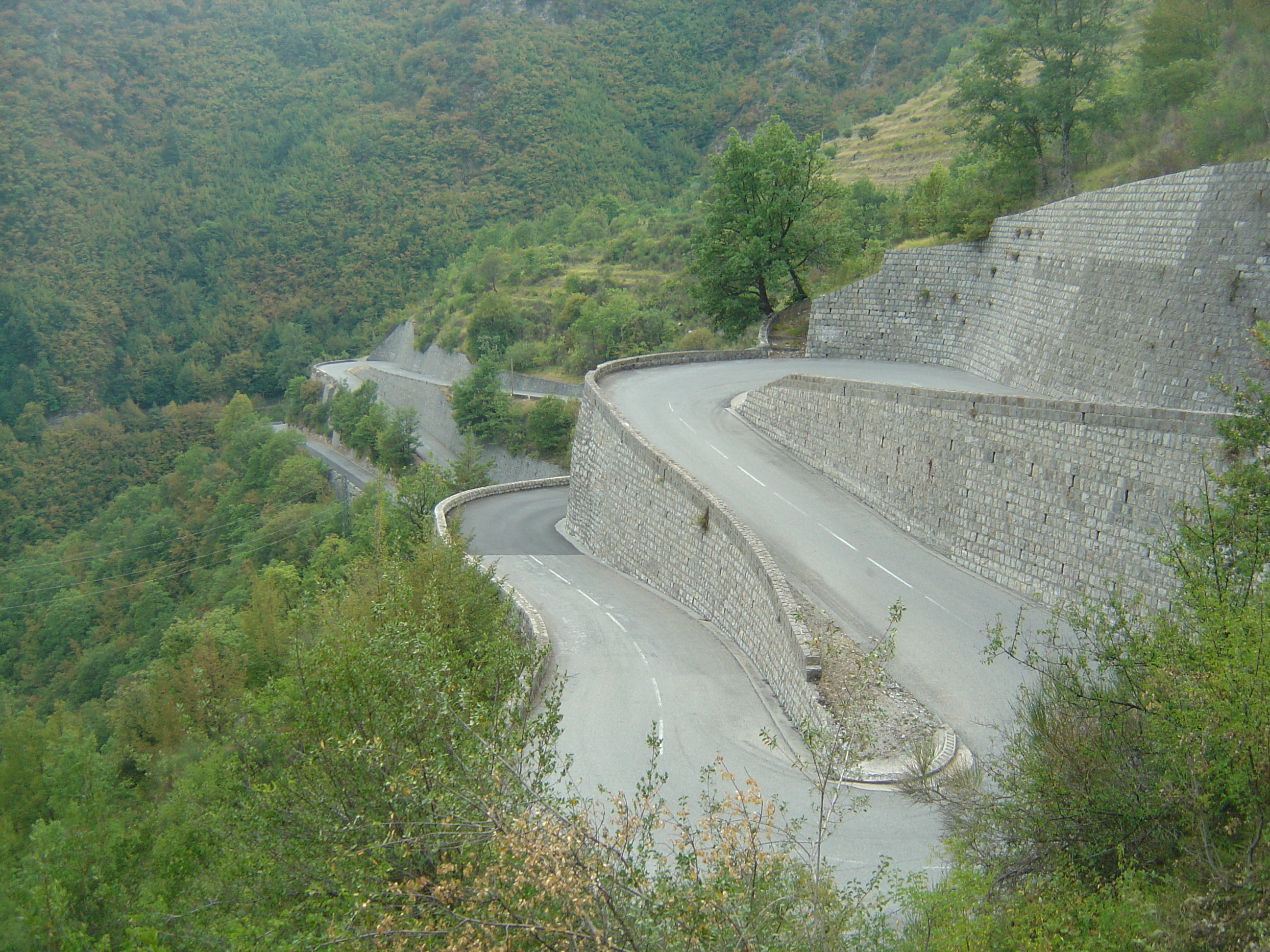
The last eleven kilometers alternate between 7.5 and 8%, without respite until the top of the Col de Turini. A large coniferous forest will help you fight the sun's heat on the final stretch. Last but not least, enjoy the exceptional series of hairpin bends that have made generations of rally drivers and spectators howl with delight!
By the north-south slope, crossing the Porte and Saint-Roch passes
This variant offers you a much longer journey: around 30 km, 1335 m of positive ascent, at an average gradient of 5.5%... and two additional passes (one of which, Saint-Roch, is crossed on the descent).
It's at Lantosque that the paths part. Assumption 1: you continue on the normal route via the western slope. Option 2: you take the alternative route over the Col de la Porte, then the Col de Saint-Roch, before climbing back up towards the Col de Turini (1604 m).
This second option gets off to a quiet start. The first 6.5 km after Lantosque are at 5% up to St-Arnoux, followed by a descent to the Pont de l'Infernet.
After the warm-up, the serious stuff begins with the ascent to the Col de la Porte (1057 m): 6.8 km at 7.5%, with the last 450 m at 9.5%. A 2.5 km descent soon takes you to the Col de Saint-Roch (990 m).
That's where things get a little more complicated! Your next objective, La Baisse de la Cabanette (1372 m), isn't cheap! Almost four kilometers at an average of 9.5%, including 600 m at 10.5%. The last kilometer at 3.5% helps you recover.
Then you're 10 km from the goal, via Peïra Cava. Apart from 500 meters at 9%, the route is nothing but a series of false flats going up and down. After passing a high point at 1609 m, all you have to do is let yourself slide down to the Col de Turini.
Map of the route up the Col de Turini by bike from the Vésubie valley, via the west side
Cycling up the Col de Turini from Sospel, by the south side
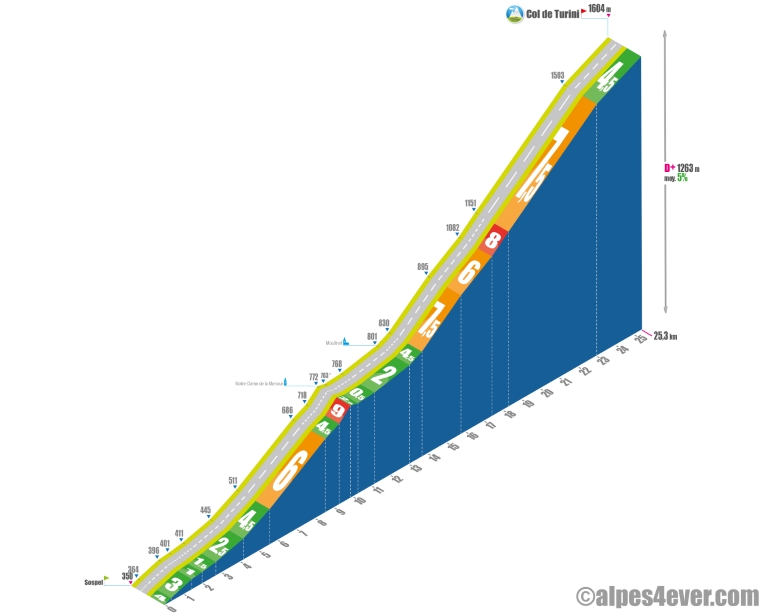 Start: Sospel, Nice hinterland (364 m)
Distance: 24.7 km
Altitude: 1604 m
Vertical rise: 1480 m
Average gradient: 5.2%
Maximum gradient: 9.3%
Tour de France® rating: hors catégorie
Cycling time up the Col de Turini from Sospel, via the south side
- At 7 km/h: 3 h 30
- At 11 km/h: 2 h 20
- At 15 km/h: 1 hr 40
- At 19 km/h: 1 hr 20
Map of the route up the Col de Turini by bike from Sospel, via the south side
Description of the ascent of the Col de Turini by bike from Sospel, by the south side
Variants, more variants! Let's start with the "normal route": 25.3 km from Sospel (350 m), for 1480 m of ascent at an average gradient of 5%. This slope, via Moulinet, is the one used by Route des Grandes Alpes ®, in the south-north direction.
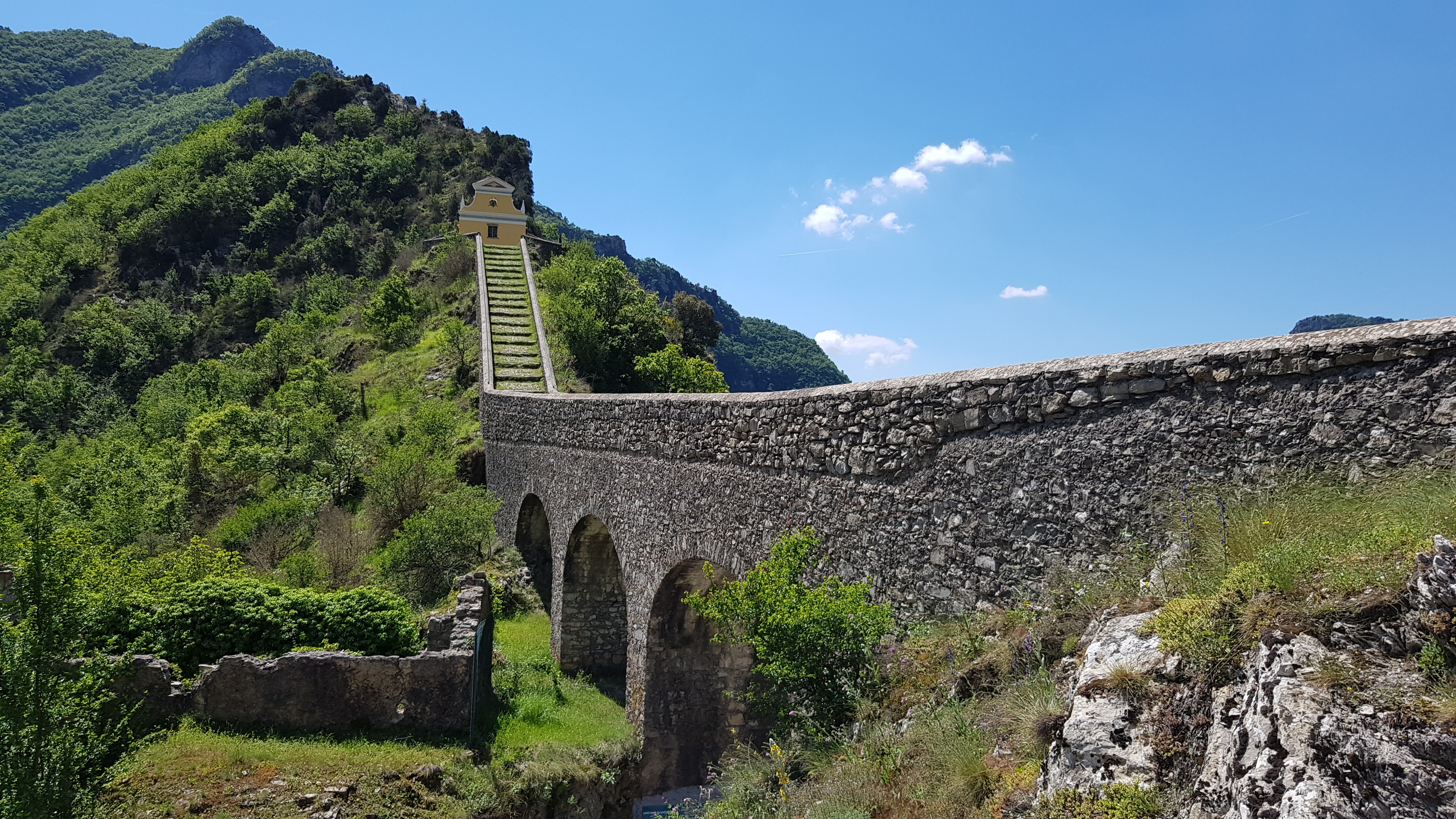
The first section of the climb goes up the Piaon gorges for around ten kilometers. Nothing too strenuous, with the exception of a few hundred meters at 9% in the hairpin bends that precede the passage in front of the chapel of Notre-Dame de la Menour.
Hanging at 780 meters on a rocky outcrop at the end of the gorges du Piaon, above the Bévéra valley, this pilgrimage sanctuary, a protected and listed site, is distinguished by a long staircase ramp dating back to the 17th century. The ramp begins with a 42-metre stone bridge, which you're about to walk under.
After the chapel, it's a leisurely 3 kilometers to the village of Moulinet, 800 meters above sea level, in the Mercantour National Park. This is where things get serious. There are a dozen kilometers to go, most of them at an average gradient of 6-8%... and some very nice twists and turns! The last two kilometers, at 4.5% D+, allow you to enjoy a leisurely arrival at your destination.
Variants as if it were raining!
There are many other ways to climb the Col du Turini from Sospel. Starting with the 6-pass variant: via Col Saint Jean (642 m), Col de Braus (1002 m), Col de l'Ablé (1149 m), Col de l'Orme (1005 m), Pas de l'Escous (1008 m) and Baisse de la Cabanette (1372 m). Before reaching the Col de Turini via Peïra Cava.
To discover the other variants, we refer you once again to alpes4ever.com. Thanks Joris for your superb work!
Tips for preparing to climb the col de Turini
Attention, certain parts of the road are very exposed to the sun. Ascent "à la fraiche" recommended!
Our advice:
- The first major pass on Route des Grandes Alpes® if you set off from Nice, the Col de Turini will put your fitness to the test, especially if it's hot. Leave well trained.
- Transfer and transport of luggage, reservation of hotels, B&Bs, gîtes and other types of accommodation, guidance and accompaniment, bike and VAE rental, choose your travel agency. Discover which specialist to go with on Route des Grandes Alpes®
- Selection of equipment, outfits, preparation, maintenance: here's equipment required for the Route des Grandes Alpes®
Weather conditions for the Col de Turini
Close to the Mediterranean and crowned by the Turini Camp d'Argent ski resort, the Turini Pass is open all year around. For traffic conditions visit inforoutes06
For weather conditions, you can visitthe dedicated page on meteoblue
Finally, click here to know when to go on Route des Grandes Alpes ®
Recommended equipment for the Col de Turini
The Col de Turini is a medium altitude pass where, if you've taken the time to check the weather forecast beforehand, you won't be risking much. Beware, however, of heat and hunger pangs! Take plenty of water and snacks, even if you cross villages on both sides.
The Col de Turini has many switchbacks. So this is no time to be delicate with your brakes. Don't forget to check your bike or have it checked before setting off.
If you're on a VAE, check your battery charge before setting off. A discharged electric bike is heavy! Please note that there are no "official" charging stations on the route. Ask shopkeepers or restaurateurs during your coffee break or meal.
Route des Grandes Alpes® Gravel also passes through the Col de Turini: discover the penultimate stage of this route in gravel mode, between La Bollène-Vésubie and Coaraze, "Plus beaux villages de France".
Services at the Col de Turini
As the summit of the Col de Turini is also a ski resort, you'll easily find something to eat there in summer.
.
The villages of La Bollène-Vésubie and Lantosque (north-south axis) and Sospel and Moulinet (south-north axis) will enable you to refuel and refresh.
VAE recharging stations : none
Access to Col de Turini
SNCF and bus stations
- Nice
- Menton
Road access
- D2566 from Sospel
- M70 from La Bollène-Vésubie
Those who have done it say it best!
And finally the Col de Turini and its endless laces, the last big pass! Dominique, 70, talking about the end of his journey.
The Turini is one of my favorite passes, for its laces and its wild side. Romain, usually more of a mountain biker.
Col de Turini: quite a demanding climb of 15 km approx. Beautiful views over the sea and a rare tranquility, I passed very few cars, maybe three...
At times, the roads and scenery made you feel like you were back in the 70s. We could only wait for Louis de Funès to pass by in an old DS, or Alain Delon in his old Renault Alpine... Aloïs, Swiss from Valais.
The Col de Turini: a beautiful climb through the forest... I discovered when I got to the pass that I was going to discover the famous Monte Carlo rally lacets, so it was great to cycle them after climbing this mythical pass. Cyril Pliquet, Annecy.
From La Bollène-Vésubie, the climb is a perfect blend of nature and sporting challenge. The winding sections through the forest are a real test of endurance. Reaching the pass and looking back is an unforgettable experience. Aldina and Amilcar, cyclotourists from Lisbon.
Starting from Sospel, the route to the Col de Turini offers a unique experience. Passing by the N.D. de la Menour chapel and the village of Moulinet, just before the steepest slopes, are beautiful moments of discovery. Virginie and Stéphane, Paris.
From Sospel, the climb to the Col de Turini begins gently, but make no mistake, the final kilometers are arduous. The views over the gorges du Piaon are spectacular, a real feast for the eyes despite the effort. Olivier, Menton.
One of my worst days on a bike! The southern slope of the Col de Turini was on the program for the first stage of "my" Route des Grandes Alpes ® South-North. Setting off in the heatwave, I underestimated this piece of bravery (or overestimated my abilities!).
Bref, I sank a connecting rod in the final kilometers of the pass... I owed my salvation to a fruit paste and the shade of conifers in the final hairpins. The descent to La Bollène-Vésubie is a magnificent slide. A remarkable souvenir all the same! Lionel, co-host of Route des Grandes Alpes ®
FAQ
How many switchbacks does the Col de Turini have?
Between La Bollène-Vésubie to the north and Sospel to the south, the Col de Turini offers 34 hairpin bends.
What is the name of the resort at the Col de Turini?
The family-friendly resort of Turini Camp d'argent is around fifty kilometers from Nice. It includes two downhill ski slopes, culminating at the cime de la Calmette (1765m), and a small cross-country ski area.
What cycling tour is it possible to undertake from the Col de Turini?
At the Col de Turini many routes intersect. One of them gives you access to the Authion loop. Fifteen kilometers or so where you'll pass 2000 meters of altitude in breathtaking scenery, military relics to boot.
In which national park is the Col de Turini located?
It's in the so-called "adhesion" area of the parc national du Mercantour. Its peaks and valleys (Ubaye, Roya et Bévéra, Var et Cians, Vésubie, Haut-Verdon, Tinée) make up one of France's most beautiful natural territories.
The map
The map
27 Sospel / Nice
Other passes near the Col de Turini
Col de la Couillole | The most beautiful passes of Route des Grandes Alpes ® |