Between Maurienne and Romanche, Savoie and Isère
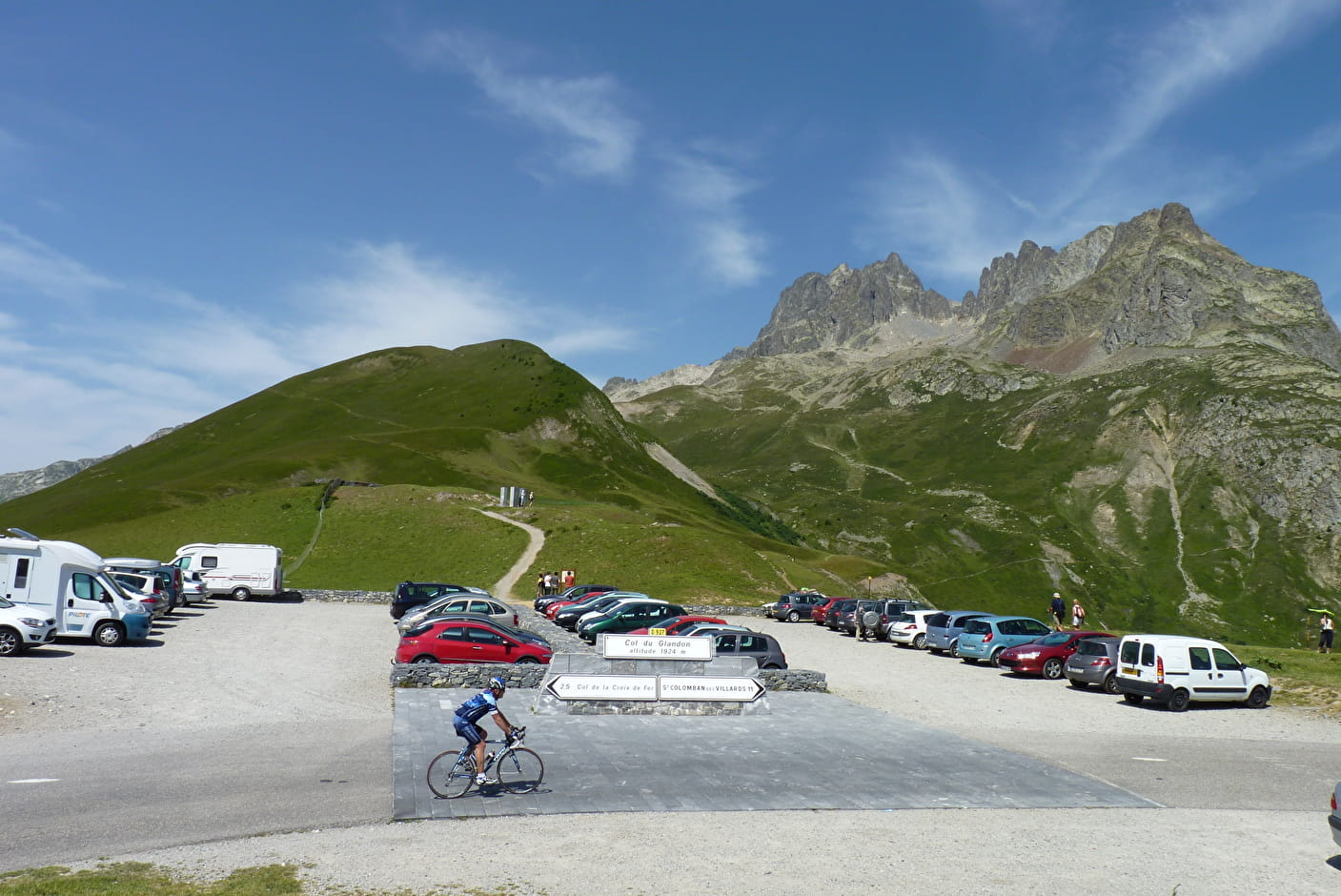
Altitude 1924 m
Belledonne and Arves Mountains
Savoie Department
Summary
- Plan your ascent of the Col du Glandon by bike
- Ascent of the Col du Glandon by bike from Saint-Étienne-de-Cuines
- Description of the ascent of the Col du Glandon by bike from Saint-Étienne-de-Cuines
- Ascent of the Col du Glandon by bike from Allemond
- Description of the ascent of the Col du Glandon by bike from Allemond
- Description of the Col du Glandon climbby bike from Allemond
- Conseils pour préparer l'ascension du col du Glandon
- Weather conditions for the col du Glandon
- Conseils pour préparer l'ascension du col du Glandon
- Services at the Col du Glandon
- Access to the Col du Glandon
- FAQ
Plan your bike ascent of the Glandon pass
This col sur Route des Grandes Alpes ® takes you from Maurienne to Romanche, from Savoie to Isère, from bucolic landscapes to large dams... Within 250 metres, its southern slope is the same as that of the Col de la Croix de Fer. Does this mean the Glandon only has its own north face? Yes, but what a north face, with one of the toughest finishes of all the Alpine passes!
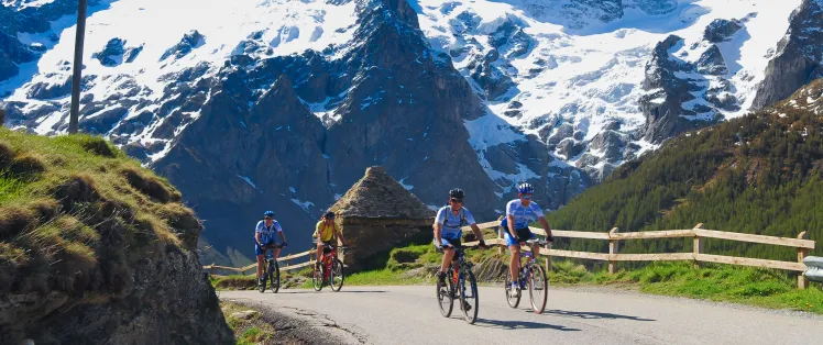
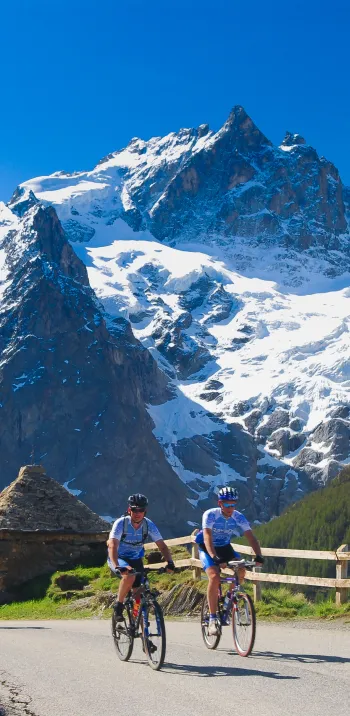
Cycling up the Col du Glandon from Saint-Étienne-de-Cuines
Topo versant Nord
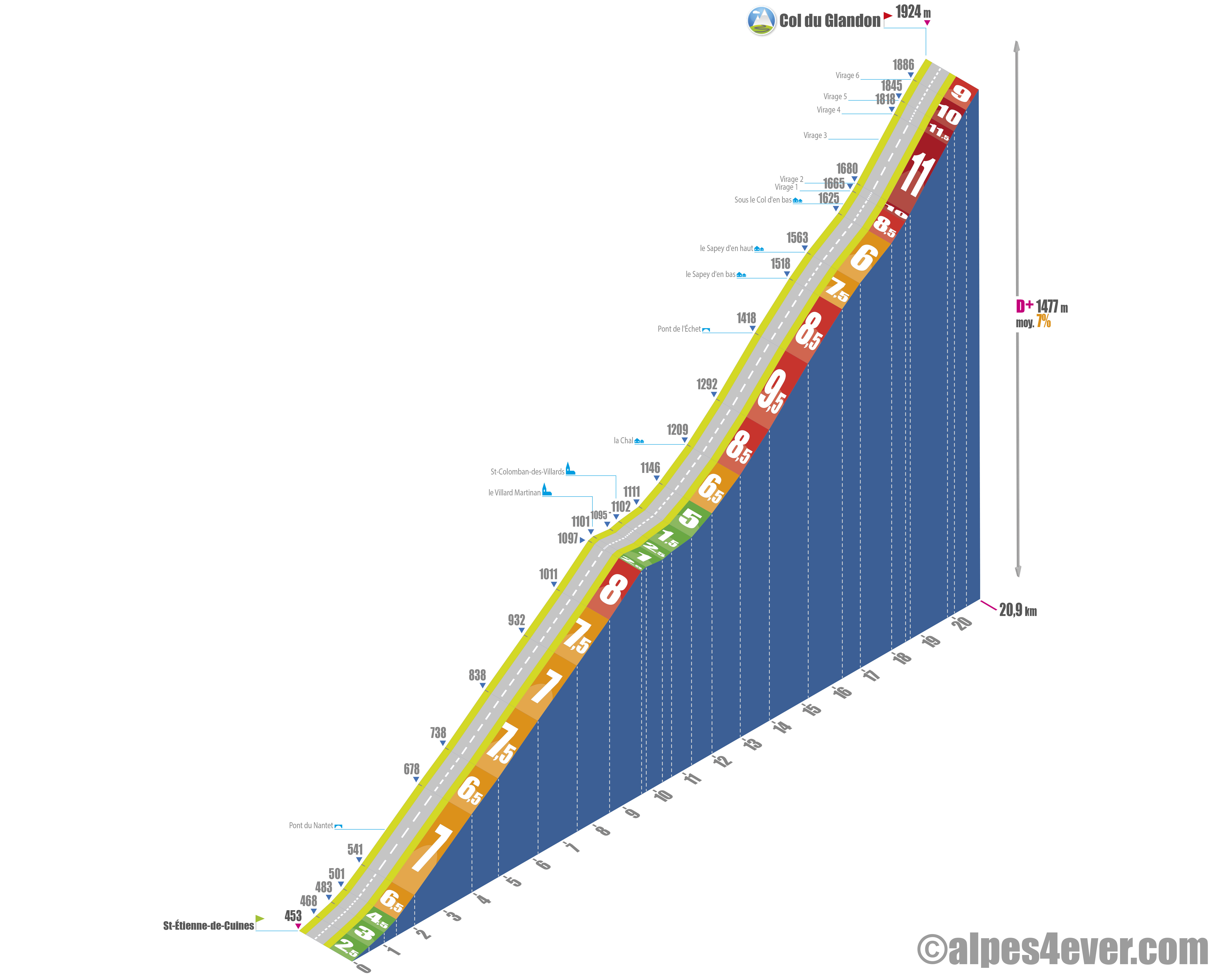
Start: Saint-Étienne-de-Cuines (453 m)
Distance: 20.9 km
Altitude: 1924 m
Elevation: 1477 m
Average gradient: 7%
Maximum gradient: 11.5%
Tour de France® rating: hors catégorie
Cycling time up the Col du Glandon (rounded) from Saint-Étienne-de-Cuines
- At 7 km/h: 3 h 00
- At 11 km/h: 1 h 55
- At 15 km/h: 1 h 25
- At 19 km/h : 1 h 05
Map of the route up the Col du Glandon by bike from Saint-Étienne-de-Cuines
Description of the ascent of the Col du Glandon by bike from Saint-Étienne-de-Cuines
If, in Bourg-Saint-Maurice, you've chosen the variant that takes you from Tarentaise to Maurienne via the Col de la Madeleine, there are several choices open to you once you've completed the descent from the Madeleine.
Choice number 1
You can head up the Arc and Maurienne rivers, towards Saint-Michel-de-Maurienne, then return to the main Route des Grandes Alpes® route via the Col du Télégraphe and Col du Galibier.
Choice number 2
You can reach Saint-Jean-de-Maurienne, then Saint-Jean and Saint-Sorlin-d'Arves before climbing the final switchbacks to the Col de la Croix de Fer.
Choice number 3
You can cross the Arve at La Chambre and reach Saint-Étienne-de-Cuines to immediately attack the climb to the Col du Glandon, via the small resort of Saint-Colomban-des-Villards. It's this very difficult climb, characterized by a terrible finish, that we're now taking you on.
Until after the Saint-Colomban-des-Villards pass, in fact until kilometer 13, it's not too bad. The first 1,500 meters, where you go from 2.5% to 4.5%, are perfect for warming up. The next eight kilometers, where you ride mainly under the cover of trees, alternate between 6.5 and 7.5%. A segment at 8%, but only for the last thousand meters.
And it's precisely at the end of this 8% section, just before arriving at Villard Martinan, that you'll eat your white bread. Two and a half kilometers of near-flatness, concluded by 675 meters at 5%. As a bonus, as the valley widens, you'll enjoy the first panoramic views of the Massif de Belledonne and the authenticity of the village-resort of Saint-Colomban-des-Villards.
For those who want to add to the climb (+102 m) and distance (+2.9 km): it's possible to do a nice loop via Saint-Alban-des-Villards. There's no risk of getting lost, it's well signposted and you'll find the normal route again just before Villard Martinan.
Let's close this short parenthesis and get back to crossing Saint-Colomban-des-Villards. On leaving the village, and after crossing a bridge, the slope gradually levels out. At the end of a kilometer at 6.5%, at a place called La Chal, you're at km 13 and there are still eight kilometers of ascent where the slope won't do you any favors.
Leaving La Chal, you skirt the Glandon torrent, with a positive vertical drop of 209 m over a distance of 2.3 km. The gradient averages 9%. This section is particularly demanding: it's impossible to breathe in the bends, and the sun beats down hard the whole way!
A little mercy between Sapey d'en bas and Sous le Col d'en bas, where the gradient offers 2.5 kilometers at 7.5 then 6%. The scenery is splendid, but the three-kilometer final stretch that lies ahead is undoubtedly one of the most difficult in the French Alps.
From the Sous le Col d'en bas hut, you begin a six-lacet ascent with an impressive gradient! The landscape, dominated by the majestic Aiguilles de l'Argentière, offers a spectacular backdrop. You'll gain 299 m in elevation gain in less than 3 km (2.9 km), with an average gradient of 10%. Between bends 1 and 6, the gradient varies between 10 and 11.5%! The last 425 meters, though 9%, are almost a liberation that you can celebrate on the terrace of the Chalet du Col du Glandon.
Cycling up the Col du Glandon from Allemond
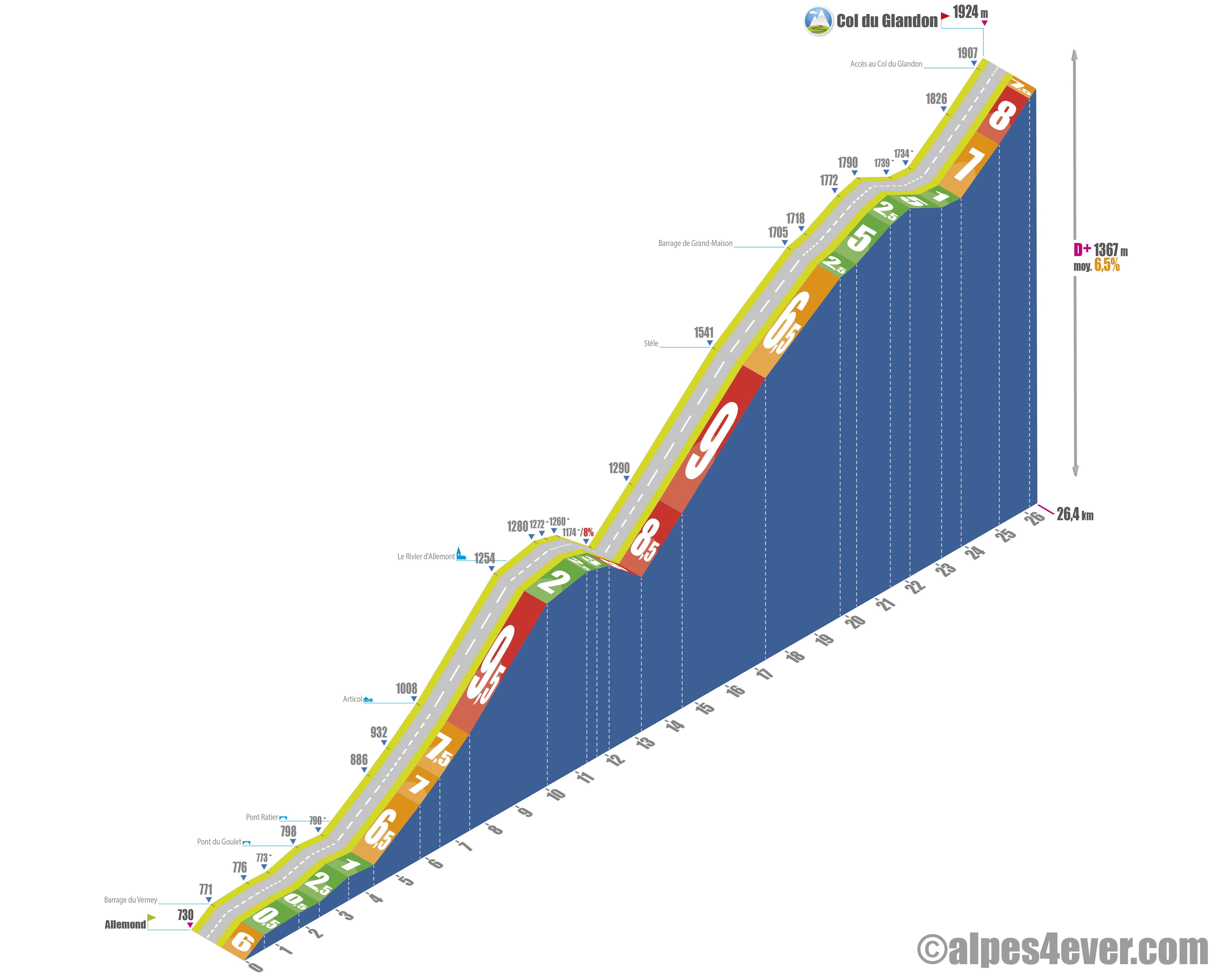
Start: Allemond (730 m)
Distance: 26.4 km
Altitude: 1924 m
Elevation: 1367 m
Average gradient: 6.5%
Maximum gradient: 9.5%
Tour de France® rating: hors catégorie
Cycling time (rounded) up the Col du Glandon from Allemond
- At 7 km/h: 3 h 45
- At 11 km/h: 2 h 25
- At 15 km/h: 1 h 45
- At 19 km/h : 1 h 25
Map of the route up the Col du Glandon by bike from Allemond
Description of the ascent of the Col du Glandon by bike from Allemond
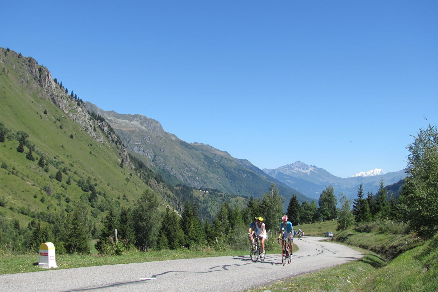
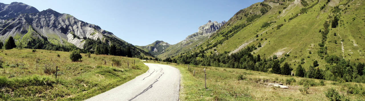
The south side, shared with the Col de la Croix de Fer, is a long and varied 26.4 km climb, combining arduous slopes and a few short descents. Along the way, you'll come across several waterfalls and skirt Lac de Grand'Maison.
The route begins in earnest in Allemond, in the Romanche valley at the foot of the Lac du Verney dam, with an initial climb of 650 m at 6%. This is followed by a gentler 2.5 km stretch along the lake, with a maximum gradient of 2.5%. After rounding the imposing Eau d'Olle power station, a gentle descent takes you to Pont Ratier, marking the entrance to the Vallée d'Olle and the start of the climb.
The next 3.2 km, with an increasing gradient from 6.5 to 7.5%, take you up to Articol. Ideal for getting into the swing of things! The next section is tougher: 2.6 km with a 9.5% gradient, on a fairly straight, shady route that makes it easier to endure the difficulty. A flat area before Le Rivier d'Allemont offers a welcome short break.
After a good descent of around 1.8 km, a fairly steep section appears at the entrance to the défilé de Maupas: a straight stretch of 2.3 km interrupted by only 2 hairpin bends with a gradient of 8.5/9% that forces you to change gear immediately. This difficult section leads to the foot of the Barrage de Grand'Maison. 2 hairpin bends at 6.5% for 2.5 km are needed to reach the top. The route continues over the lake, with gradients between 2.5 and 5% for 2.3 km, before descending to a bridge marking the border between the departments of Isère and Savoie. The ascent resumes for 2.3 km with a gradient of 7-8%, crossing alpine pastures.
At the intersection, you abandon the road leading to the Col de la Croix-de-Fer for a short final climb of 230 m at 7.5% that takes you to the Col du Glandon.
Conseils pour préparer l'ascension du col du Glandon
Length (especially on the south side) and difficulty (especially on the north side) characterize the ascent of the Col du Glandon. We're assuming you'll be well prepared for it. If you keep your pace moderate and regular, especially at the start of the climb, and don't burn up too much energy, you'll be fine. A little psychological trick to make the battle less intimidating: divide the pass into sections, by kilometers or landmarks.
Our advice:
- This isn't the col de l'Iseran in terms of altitude, nevertheless breathe regularly and deeply to maximize your oxygenation. If you feel headaches or a drop in performance, slow down and above all listen to your body.
- Drink regularly, in small sips every 10-15 minutes. Even in cool weather, exertion at altitude leads to dehydration.
- Take care with your energy intake. Plan carbohydrate-rich snacks (energy bars, gels, dried fruit) every 45 minutes or so. Eat before you feel hungry to maintain your energy.
- The Col du Glandon belongs to the Oisans Col Series program. This means it can be climbed without cars and with a nice snack at the top. Find out about dates from Oisans Tourisme.
- Vélorizons and LaRébenne are reputable travel agencies for itinerant cycling holidays. They provide all the services needed for a successful trip: luggage porterage, accommodation selection and booking, guiding, bike rental if required. We recommend them for trips on Route des Grandes Alpes ®. Discover which specialist to go with on Route des Grandes Alpes®
Weather conditions for Col du Glandon
The summit of the col du Glandon is almost 2000 meters high. So check the weather forecast and avoid days with strong winds, rain or thunderstorms. Conditions can change quickly in the mountains, so be prepared to give up in case of bad weather.
The Col du Glandon is usually open to traffic in late May / early June. It closes in November. To check opening and practicability, visit savoie-route.fr ("État des cols" / "Données cartographiques" section).
To check the weather at the top of the Col du Glandon: www.meteoblue.com/en
To find out what time of year to set off on Route des Grandes Alpes ®
Recommended equipment for Col du Glandon
In cols, we often talk about the ascent, more rarely the descent. Here are a few recommendations to make the most of them in terms of pleasure and recovery.
Wear layered technical clothing that's easy to take off or put back on. Bring a windbreaker for the descent and good gloves to avoid the cold of the heights. If possible, don't hesitate to dress a little before the summit. You won't have time to sweat, and you'll avoid getting cold when you pass the pass.
Check your brakes, tires and transmission before you set off. To descend safely, you need effective brakes and perfect grip. Before you set off, find out the profile of the pass: it's useful on the way up, it's just as useful on the way down.

A bike for travel at a low price?
Alltricks offers a new range of reconditioned bikes to get well equipped at low prices!
Find a selection of Road - Gravel bikes suitable for Route des Grandes Alpes by clicking here!
Services close to the Col du Glandon
On the north side, Savoie side, you can refuel at La Chambre at the bottom of the Maurienne valley, just before the start. In the middle of the climb, you can also stop off at the small village resort of Saint-Colomban-des-Villards.
South side, Isère side, refuel at Bourg-d'Oisans, or a little further on at Allemond, because after that you won't find anything until the pass.
VAE charging stations : Bourg d'Oisans
Access to the Col du Galibier
SNCF and bus stations
- Saint-Jean-de-Maurienne (73)
- Grenoble (38)
- Le Bourg-d'Oisans (38)
Road access
- A43 autoroute de la Maurienne, exit n°26 La Chambre
- D927 from Saint-Étienne-de-Cuines to the pass
- D1091 from Le Bourg-d'Oisans
- D526 from Allemont to the pass
Those who have done it speak best of it!
.jpg)
"The Col du Glandon: because it's a big pass, it's hard, I'd never done it and at the top it's magnificent." Laurent Chiabaut, during his Annecy Cagnes-sur-Mer crossing.
"Well misnamed this Col du "Glandon". Because you have to work hard to climb it!" The bruised joker.
"Going up the south side, I went for the Croix-de-Fer. Almost 3 kilometers at 6%. The double within reach, that's not to be refused!" Mahel.
"On the Maurienne side, it's really brutal in the final kilometers. Every twist and turn seems endless." Thaïs and his group of Belgian cyclos.
"And if you want to do a bit of sightseeing and take in the sights, you can always put your bike down in Allemond and treat yourself to a round trip on the Eau d'Olle Express." Jean-François, from Grenoble.
FAQ
What's special about the southern route of the Col du Glandon?
It's in common with the southern route of the Col de la Croix-de-Fer, from which it separates only three kilometers from the summit of the latter.
How many times has the Tour de France passed over the Col du Glandon?
On the occasion of the Vif - Col de la Loze, on July 18, 2025, the Tour de France will cross the summit of the Col du Glandon for the 23rd time. Note that 8 of these climbs did not earn points towards the Grand Prix de la Montagne (the famous polka-dot jersey), because they merged with the ascent of the Col de la Croix-de-Fer.
What's the name of the large lake on the south side of the Col du Glandon?
It's the Lac de Grand'Maison, created by the dam of the same name. Its dimensions are exceptional: 550 m long, 140 m high, with a storage capacity of 140 million m³ of water. It is quite simply the most powerful dam in France.
What are the names of the two valleys linked by the Col du Glandon?
The Vallée des Villards in Savoie, the Vallée de l'Eau d'Olle in Isère. The Glandon and Eau d'Olle are also two torrents that flow through their eponymous valleys.
The map
The map
17 Alternative stage Saint-Jean-d'Arves / L'Alpe d'Huez
Other passes near the Col du Galibier | The most beautiful passes of Route des Grandes Alpes ® |