Birth of a Giant
Altitude 2304 m
Massif de la Vanoise
Département Savoie
Summary
- Plan your ascent of the Col de la Loze by bike
- Ascent of the Col de la Lozeby bike from Moutiers, via Méribel
- Description of the climb to the pass de la Lozeby bike from Moutiers, by Méribel
- Best bike rides near Méribel
- Bike up the Col de la Loze from Moutiers, by Courchevel
- Description of the climb up the col Bike up the Col de la Loze from Moutiers, via Courchevel
- Tips to prepare for the Col de la Loze ascent
- Weather conditions for the col de la Loze
- Recommended equipment for the col de la Loze
- Services at the services at col de la Loze
- Access to col de la Loze
- Témoignages
Plan your bike ascent of the Col de la Loze
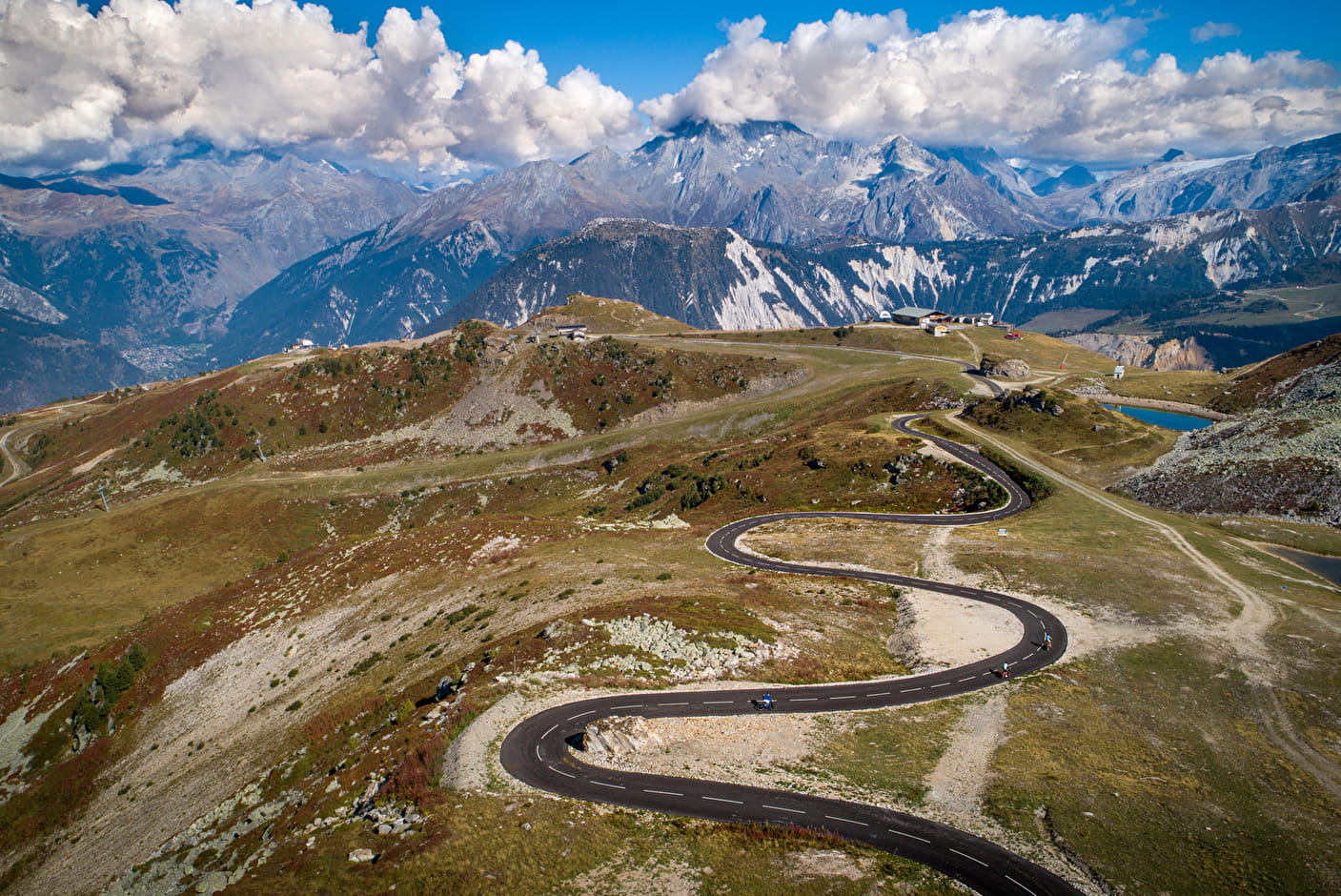
Ex-mountain pasture path, in the heart of the Three Valleys, this col on Route des Grandes Alpes ® links Méribel to Courchevel. It has only been paved since 2019, yet by 2025 it will have seen the Tour de France three times: two arrivals and one passage. That's how impressive it is! And singular too, since it ends on both sides in dedicated bike lanes: 7 km towards Méribel, 6.5 towards Courchevel.
Cycling up the Col de la Loze from Moutiers, via Méribel
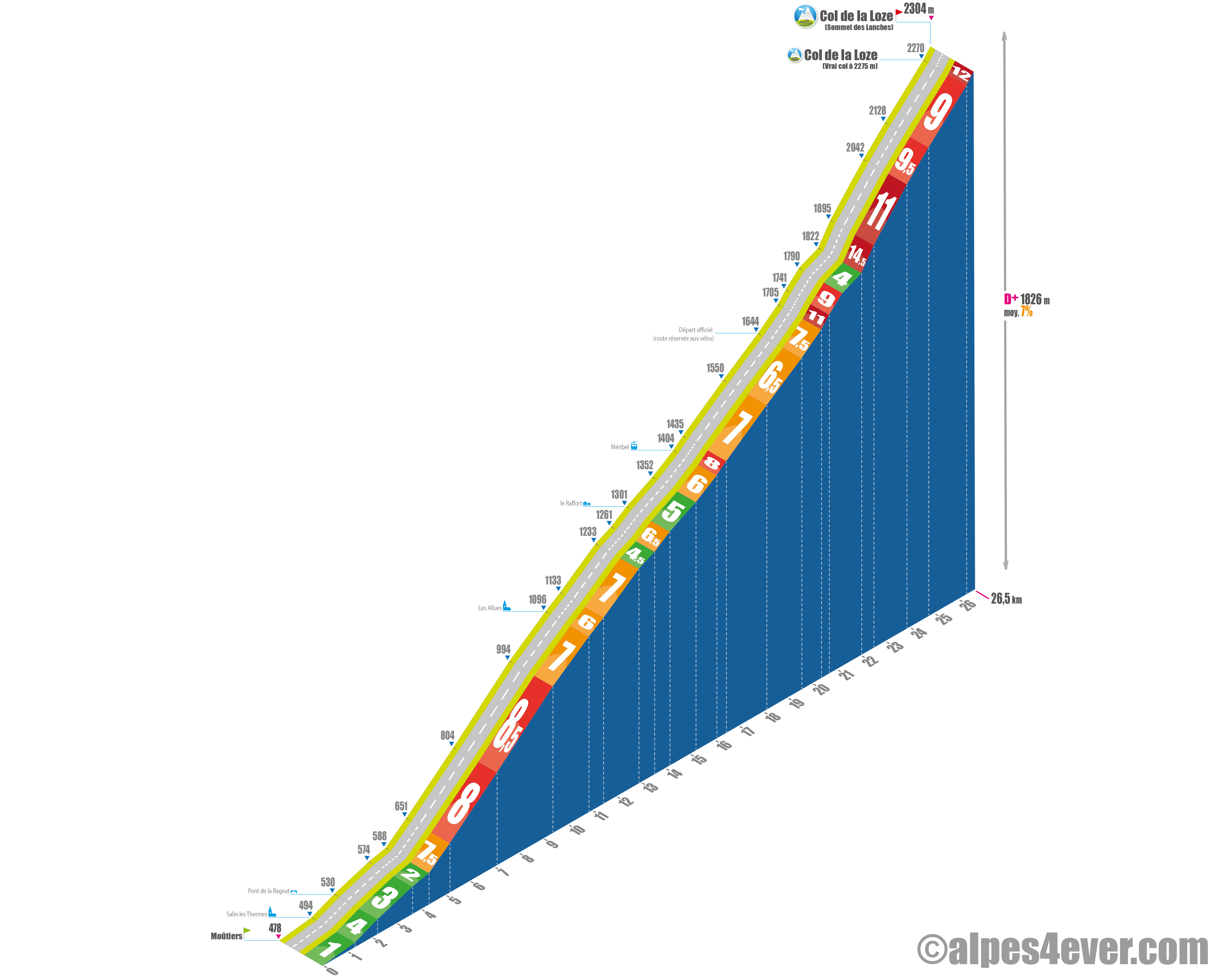
Start: Moûtiers (478 m)
Distance: 26.5 km
Altitude: 2304 m
Elevation: 1826 m
Average gradient: 7%
Maximum gradient: 12% (passes at 20%)
Tour de France® rating: outside category
Time to climb (rounded) Col de la Loze by bike from Moutiers, via Méribel
- At 7 km/h: 3 h 50
- At 11 km/h: 2 h 25
- At 15 km/h: 1 hr 50
- At 19 km/h: 1 hr 25
Map of the route up the Col de la Loze by bike from Moutiers, via Méribel
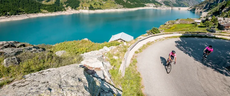
Description of the ascent of the Col de la Loze by bike from Moûtiers, via Méribel
The Col de la Loze ascent starts in Moûtiers, in the heart of the Tarentaise Valley. From the train station, drive under the N90, then join Salins-les-Thermes on the D89. You then head for the spa town of Brides-les-Bains, around 5 km away. Climb between 1% and 4% for just over 4 km, with one section at 9% as you leave Salins. At Les Frasses, turn right onto the D90D, which winds down to Brides-les-Bains. Things get serious as soon as you leave Brides-les-Bains, with a 10% gradient on the D90C.
You pass over the D915, then turn left onto the D90 and begin the climb to the village of Les Allues, perched at 1096 m altitude. You reach it by climbing six switchbacks over almost as many kilometers. You're in a sustained portion of the route, as the gradient then varies between 7% and 8.5%.
At Les Allues, you'll have completed around a third of a 26.5 km ascent. Same proportion of D+: already over 600 metres behind you... and 1200 ahead. The next section takes you to the resort of Méribel-les-Allues (1404 m) via the hamlet of Le Raffort. Just over 5 km at 6%, enough to take a breather, but not too much!
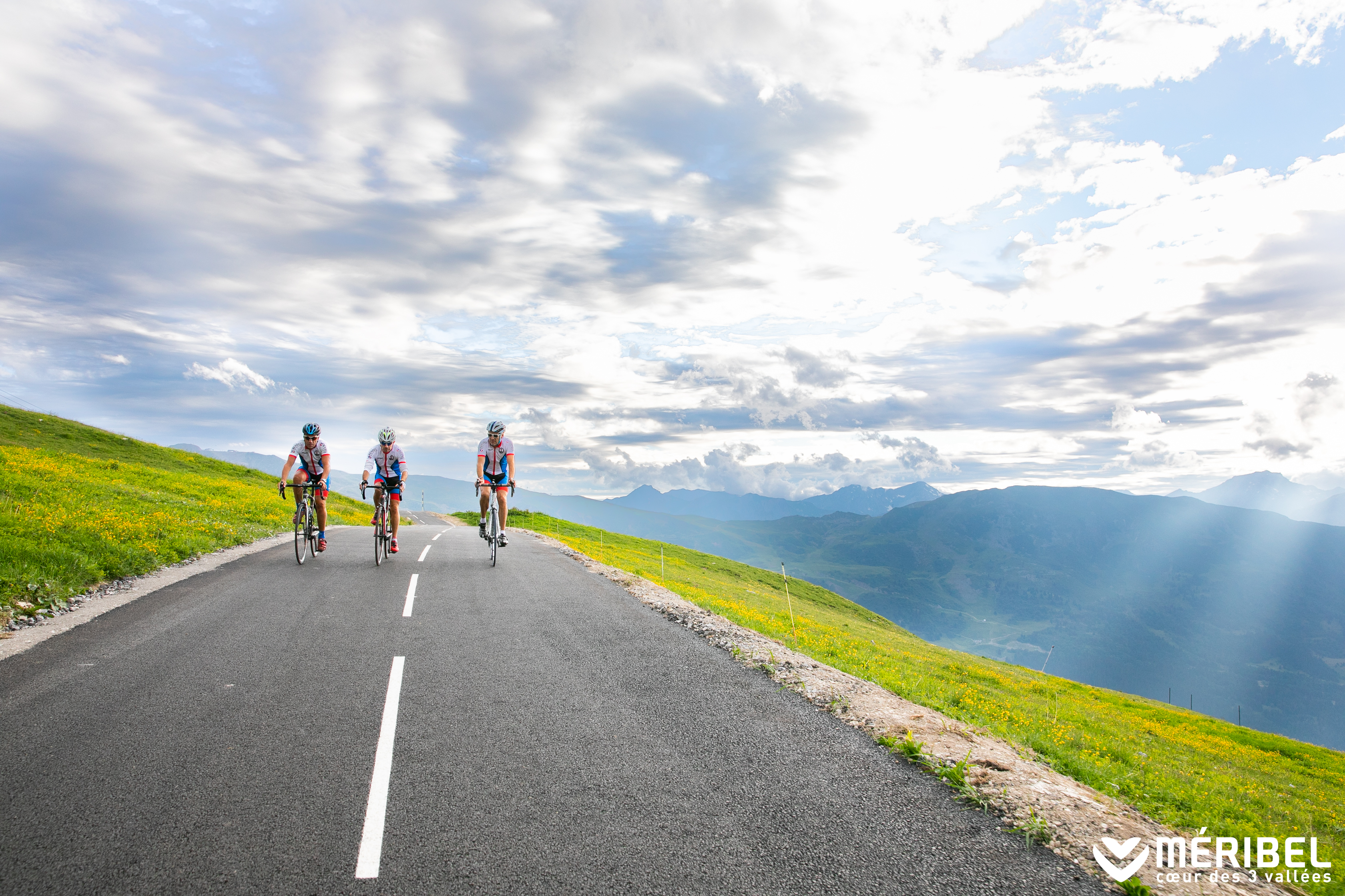
At Méribel, you turn left onto a steeper road towards the starting point of the cycling section. This segment, with seven hairpin bends over 3.5 km, has gradients of between 6.5 and 8%. Here you follow the Route du Belvédère, ignoring the junction leading to the Altiport.
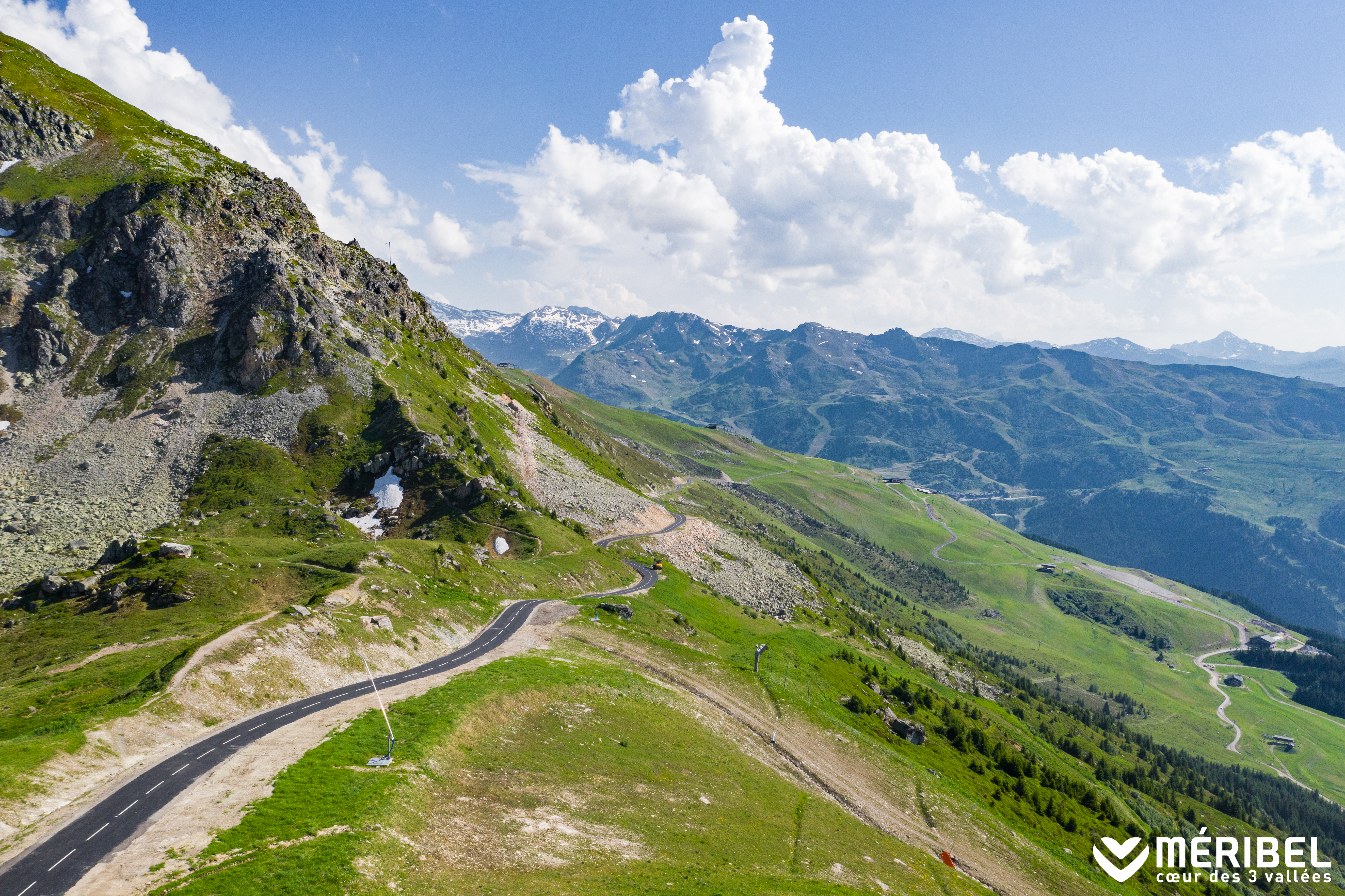
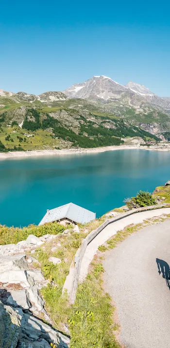
You are now at 1644 m, the start of the final section of the climb: 7 km of a gruelling ascent with a 660 m vertical drop and an average gradient of 9.5%. You're on a ski slope, and you can feel it! On the plus side, apart from the occasional alpacist vehicle, you'll be able to suffer in peace and quiet, far from any car traffic.
It starts in the Bois de la Frasse, at almost 2500 m on an irregular slope with frequent variations: 7.5%, 11%, 9%, and even 4% to recover a little.
Further on, the landscape opens up. The trail then curves upwards for 500 m, with a steep 14.5% gradient, to a strategic point at 1895 m, not far from the arrival station of the Rhodos gondola. Be careful, as this section will surprise you with gradient changes approaching 20%! 4 km remain, but not the easiest. You'll first reach the 2000 m climb, crossing 1350 m at 11%. The trail continues northwards, along the slopes of Rocher de la Loze. A long, straight ramp awaits you. Almost 2500 m with an average gradient of over 9%. Extremely photogenic, but very tough!
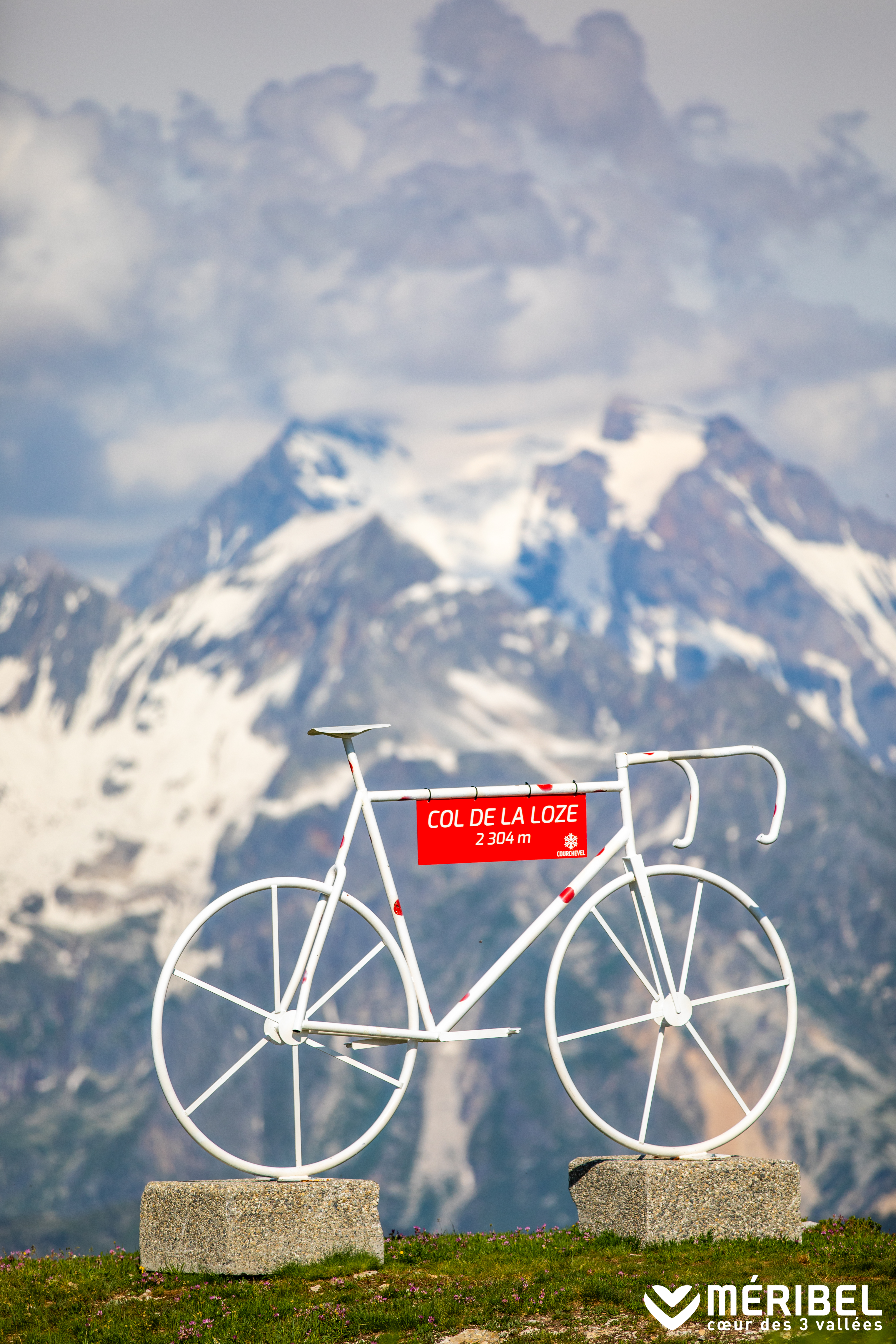
At 2270 m, you pass close to the "real" Col de la Loze, at 2275 m. Spectacular views over the Doron des Allues valley and the summits of the Maurienne. There's another 300 m to go, just as you've experienced so far. 12%, punctuated by short sections sometimes reaching 15%. This section takes you to the summit of Les Lanches, also known as the "false" Col de la Loze (your "real" objective), at 2304 m.
At the summit, marked by the presence of a giant bicycle, enjoy a well-deserved break on the terrace of the high-altitude restaurant. Breathtaking views of Mont Blanc!
The best bike rides near Méribel
At the heart of the 3 Valleys, Méribel is a veritable paradise for cycling enthusiasts. Whether you're a road or mountain biker, the surrounding area offers a variety of routes with breathtaking panoramas. From mythical mountain passes to forest trails and winding roads, every outing promises a unique experience. Here are 4 must-do routes to discover by bike around Méribel.
The Col de la Loze ascent: an exceptional challenge
The Col de la Loze has become a benchmark for cyclists. Located at an altitude of 2304 meters, it links Méribel to Courchevel via a road entirely dedicated to bikes. With no motorized traffic, the climb offers a true mountain experience. It's a demanding climb, with gradients of over 20%, but the reward is immense: a breathtaking panoramic view of the Alps. The pass has even hosted a stage of the Tour de France, proving its appeal to cycling enthusiasts.
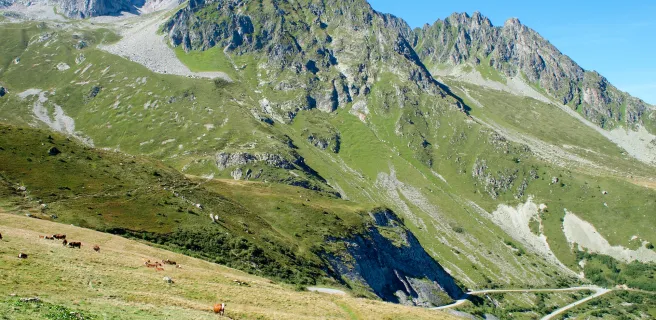
As you ascend, you pass through grandiose landscapes alternating between alpine meadows and rocky passages, where marmots and ibex can be spotted. For cyclists looking for a challenge, this route represents a formidable but rewarding test. It's best to be well-prepared and adapt your pace to take full advantage of the climb. Once at the summit, a moment of contemplation is in order before beginning the descent, which also offers unique sensations.
The Tour du Lac de Tueda: an accessible walk
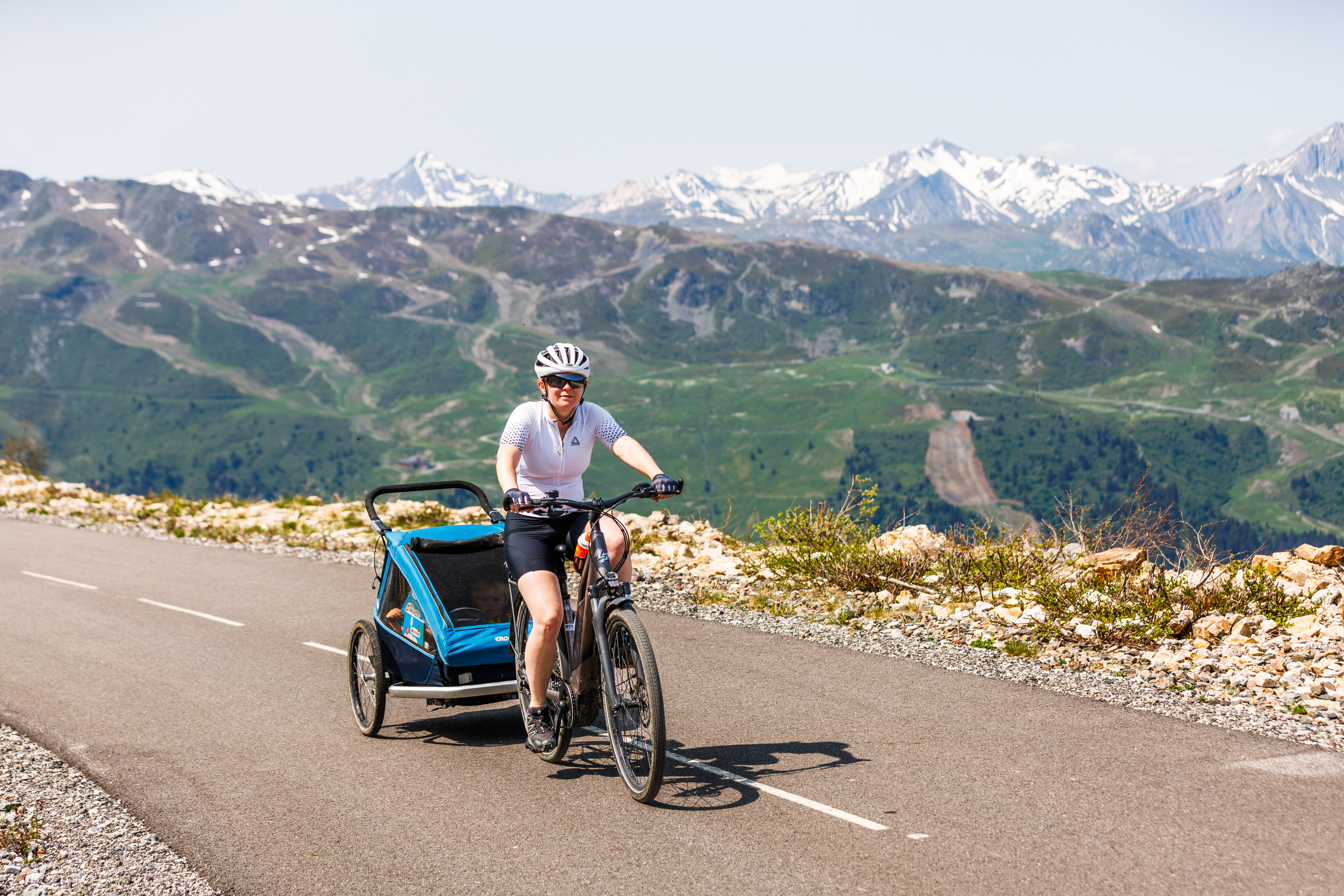
For a more leisurely outing accessible to all, the Tour du Lac de Tueda is perfect. Nestled in the heart of the Vanoise Natural Park, this trail offers an idyllic setting for a family stroll or a relaxing outing. The well-maintained trail winds through unspoilt countryside, forests and alpine meadows. With its crystal-clear waters, the lake is an excellent place to stop and admire the local wildlife. This route is ideal for mountain bikers or electric cyclists wishing to enjoy the scenery without excessive effort.
Pedalling around the lake, you can observe a wide variety of animal and plant species unique to this protected region. The lack of steep gradients makes this ride accessible to children and those wishing to avoid an overly strenuous outing. In summer, it's possible to extend the excursion by exploring the trails leading up to the Saut refuge.
The climb to Les Menuires: a sporty outing
Cyclists who enjoy long climbs will appreciate the climb to Les Menuires. Departing from Méribel, this route takes a winding, gradual route through several typical mountain hamlets. With around 1,000 meters of positive ascent, this outing requires constant effort, but remains affordable for well-trained cyclists.
Between spruce forests and alpine meadows, the route offers a diversity of scenery until you reach the resort of Les Menuires. This ascent is also an opportunity to discover the mountain heritage, with traditional chalets and alpine farms where you can stop to taste local specialties such as Savoy tomme. If you're feeling sporty, you can extend your outing by heading for the Col de la Madeleine or the Col du Télégraphe for an even more intense challenge. The descent offers pure pleasure, with tight turns that will test your agility and bike control.
La Saulire mountain bike descent: thrills guaranteed
Thrill-seekers won't be disappointed with the mountain bike descent from La Saulire. Accessible via the ski lifts, this is one of the most spectacular runs in the 3 Vallées. It starts at an altitude of over 2,700 metres and offers a technical and fun descent. The trails alternate between rocky sections and undergrowth paths, with magnificent views of the Vanoise massif.
This descent is a real playground for experienced mountain bikers, with committed sections and natural modules to work on technique and piloting. For those new to the discipline, more accessible routes are also available for a smoother, more gradual descent. It's important to have the right equipment to make the most of this outing in complete safety.
At the finish line, a well-deserved break is in order in one of the high-altitude chalets to enjoy a good mountain meal and share your experience with other enthusiasts. It's a breathtaking adventure for adrenaline-seeking mountain bikers.
Cycling up the Col de la Loze from Moutiers, via Courchevel
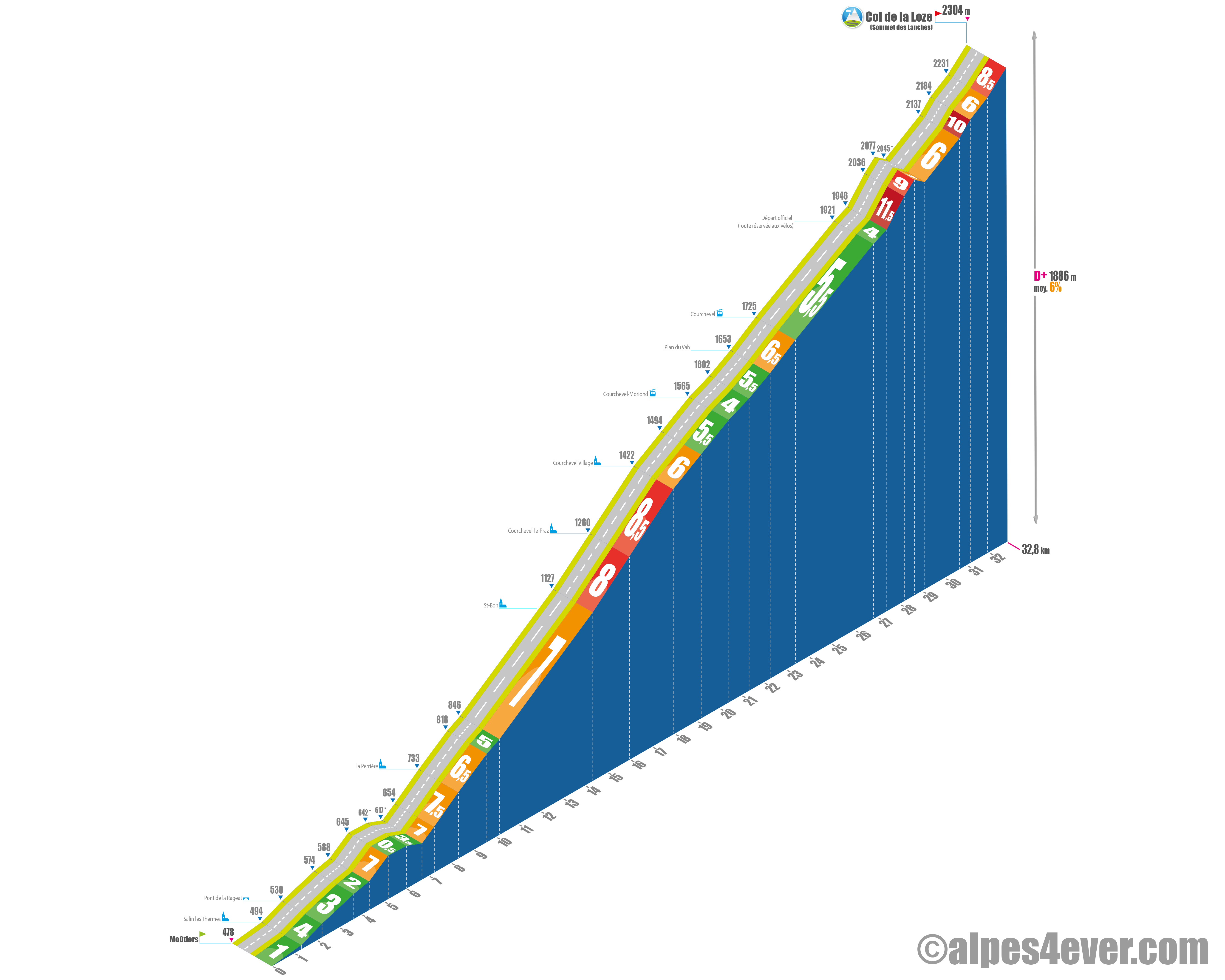
Start: Moûtiers (478 m)
Distance: 32.8 km
Altitude: 2304 m
Height difference: 1886 m
Average gradient: 6%
Maximum gradient: 11.5%
Tour de France® rating: outside category
Cycling time up Col de la Loze from Moutiers, via Courchevel
- At 7 km/h: 4 h 40
- At 11 km/h: 3 h 00
- At 15 km/h: 2 h 10
- At 19 km/h : 1 h 45
Map of the route up the Col de la Loze by bike from Moutiers, via Courchevel
Description of the ascent of the Col de la Loze by bike from Moutiers, via Courchevel
The ascent of the Col de la Loze from Moûtiers via Courchevel is longer and a little less sustained than via Méribel: 32.7 km, 1886 m D+, 6% average.
Whether you've planned your ascent via one or other of these two great Three Valleys resorts, it all starts in Moûtiers, at the bottom of the Tarentaise valley. The first 5 km to Brides-les-Bains are also common to both routes. This section is fairly gentle: 1 to 4% D+ for 4.3 km, with a 9% gradient just outside Salins-les-Thermes.
From Brides-les-Bains, you join the D915 at Vignotan. Here, the gradient steepens again: 7% for 2.9 km, passing through La Perrière. A gentler section of 550 m at 5% then leads to the Saint-Bon junction, where you leave the D915 for the D91. At this point, you have around 18 km to the summit of La Loze.
You'll successively pass Saint-Bon, Courchevel-le-Praz and finally Courchevel Village, with an average gradient of 7.5% over almost 8 km. Between the fourteenth and eighteenth kilometers, the gradient gradually rises from 8 to 8.5%, just before reaching Courchevel Village, at 1550 m.
From Courchevel Village the gradient eases, fluctuating between 4% and 6.5% for 5.5 km, passing through Courchevel-Moriond (1650 m) to finally reach Courchevel 1850 m. You then follow the Altiport road for 3.5 km, with an average gradient of 5.5%, to the start of the Col de la Loze cycle path, on the heights of Courchevel.
At this point, you're at 1921 m altitude. The final section of the climb represents 6.4 km with 415 m D+ and an average gradient of 7%. Much less steep than the Méribel side, but careful nonetheless!
Let's first break down the first third of these 6.4 km:
- First 600 m at 4%. Cool!"
- 800 meters at 11%. That wakes you up...
- Followed by 450 m at 9% to the start of the Verdons Télécabine. No time to go back to sleep.
After passing 2000 meters altitude, a short descent of 470 m offers a welcome respite. The next segment of 1550 m at 6% is very affordable, winding under the chairlifts and offering splendid panoramas of the Rocher de la Loze ridge and the Tarentaise peaks, as well as a plunging view of the Doron de Bozel valley.
But it's not quite over yet! The climb hardens again for 475 m at 10%, then the trail turns east for the final effort: 770 m at 6% and a final segment of 840 m at 8.5%, leading to the "false" Col de la Loze at 2304 m.
At the summit, you can enjoy the altitude restaurant, admire a symbolic giant bicycle, and feast your eyes on the view of Mont Blanc.
Conseils pour préparer l'ascension du col de la Loze
The Col de la Loze is not an obligation, as it is not strictly speaking on the Routes des Grandes Alpes® itinerary. If we've included it here, it's because we think there are bound to be a few pass collectors who've taken part in the Col de la Madeleine variant and can't resist adding it to their list of achievements. Be careful though, it's a detour of some fifty kilometers!
Our advice:
- If the Tour de France regularly visits this "young" col, it's because it's difficult and some passages are even very hard to climb. This observation sums up all the useful advice for climbing it: physical condition, equipment (not too heavy), bike (the right developments), etc.
- Beware of violent efforts (slope breaks, etc.) at over 2000 m altitude. We insist: very good physical condition required and, especially if you're a senior, don't forget the stress test before setting off!
- To finish, a quote from our friend Joris Lesueur, tireless devourer of passes and passionate host of the alpes4ever.com website: "This pass has already acquired quite a reputation especially in terms of its difficulty and is a scarecrow in the cycling sphere. Firstly, a monstrous difference in altitude from Moûtiers - on the Méribel side / 1826 m - on the Courchevel side / 1886 m. Then passages of between 15 and 20% at altitudes of over 2000 m. To compare, remember the last kilometer of Mont Ventoux and its 10% or the last 3 kilometers at 11% of the Col du Glandon which are under 2000 meters... short of breath, looking for air to feed the circuit... well, you'll have to take these parameters into account at over 2000 m!!!! We can only give 2 pieces of advice: be sharp and use the right gear ratio. Fashionable 50×34 / 12-28 type compacts will pass a litmus test... which will often prove cruel! "
Weather conditions for Col de la Loze
To find out when to go on Route des Grandes Alpes ®
The Col de la Loze is generally open for five months, from June to October. Every winter, the first snows transform it into a ski area. After cycling, skiing! To find out whether the pass is passable, contact the tourist offices nearby (Méribel, Courchevel).
For information on weather conditions, you're spoilt for choice.
- The webcam at the top of the pass:
- Weather at the pass, in Méribel or Courchevel: the weather channelor météo-france
.jpg)
Recommended equipment for the Col de la Loze
We're in the mountains and at 2304 m altitude, so we're careful. Nevertheless, the almost immediate proximity of civilization considerably limits the risk of hunger or dehydration, due to complicated or impossible refuelling.
Given the effort involved, you're likely to feel very hot in the last few kilometers of the climb. Don't forget to take something to cover up for the descent.
If you're using a VAE, be careful with the charge, as you're likely to put a lot of strain on the battery
.

A bike for travel at a low price?
Alltricks offers a new range of reconditioned bikes to get well equipped at low prices!
Find a selection of Road - Gravel bikes suitable for Route des Grandes Alpes by clicking here!
Services near the Col de la Loze
No refueling problems near the Col de la Loze!
On either side of the pass are Méribel and Courchevel, internationally renowned alpine resorts and flagships of the 3 Valleys. Not to mention the spa resorts of Brides-les-Bains and Moutiers, at the bottom of the Tarentaise valley.
At the pass, a high-altitude restaurant: "Le 1928".
Access to Col de la Loze
SNCF and bus stations
- Albertville (73)
- Moûtiers - Salins - Bride-les-Bains (73)
- Bourg-Saint-Maurice (73)
Road access
- N90 in the Tarentaise Valley, as far as Moûtiers.
- D915 to Bride-les-Bains
- D90 from Bride-les-Bains to Méribel
- D915, then D91A to Courchevel
Those who have done it say it best!
This "21st-century mountain pass has everything it takes to become a major Tour event for decades to come". Christian Prudhomme, director of the Tour de France.
"This climb is unlike any other col. The gradient is never regular, there can be "accessible" sections and others at 20%, you ride on a bike path in the middle of fields to arrive at 2,304 meters above sea level, you don't see that anywhere. The first time you climb the Loze, you wonder how this climb is possible. Anyone can tackle this climb, you just need to be patient and have the right gear ratios." Simon Guglielmi, French pro racer, quoted by Outlines magazine.
"From Méribel, the climb is more direct: the slope is fairly regular but sometimes really steep, it's intense, physical... On the Courchevel side, the course is more varied, a little less testing, with irregular slopes and a few moments to breathe, even if the last few kilometers are still pretty tough!" Laura, stage regional.
"A real black track!" Félix and his buddies from Annecy.
"Your altimeter may panic for a few meters, displaying a percentage close to 20%!!!.... You think you've done the hard part... but no, the 2000 m climb is going to be very painful: 1350 m at 11%! Misery, no respite... " Joris Lesueur of alpes4ever on the Méribel side.
"The last few kilometers are a struggle. You really wonder what you've come f..... in this mess!" Jérémy from Levallois.
"Frankly, climbing the Col de la Loze on an electric bike is awesome! The slopes are steep, but with the assistance, you get the most out of it without collapsing. You still feel the effort, but you're fine, and when you get to the top, the view is just incredible!" Jacky, 70.
FAQ
What's the Col de la Loze all about?
It's not just a stage finish for the Tour de France (2020 and 2025). It's also one of the most remarkable sections of the "Via 3 Vallées", a panoramic cycle path reserved for cyclists and linking Val Thorens to Courchevel. Incredible views guaranteed of Mont Blanc, La Grande Casse, the summit of La Saulire, Le Grand Bec, not forgetting Mont Blanc.
Which resorts link the Col de la Loze?
Méribel and Courchevel, two of France's biggest and most internationally renowned resorts. Both belong to the Trois Vallées ski area, which also includes Les Ménuires and Val Thorens.
What's the maximum gradient you'll encounter when climbing the Col de la Loze?
Almost 20%, fortunately on short sections. On the Courchevel side, the last 500 meters are at over 12%, while on the Courchevel side, around 2.5 km at over 11% await you on the last part of the climb.
Since 2019, when it opened, how many Tour de France events has the Col de la Loze seen?
Three, an absolute record for a very young col! Two summit finishes in 2020 (Grenoble - Méribel / Col de la Loze stage) and 2025 (Vif - Courchevel / Col de la Loze stage). To which we must add a passage in 2023, on the Saint-Gervais-Mont-Blanc - Courchevel stage)
The map
The map
9 Alternative stage Bourg-Saint-Maurice / Saint-François-Longchamp
Other passes near Col de la Loze
| The most beautiful passes of Route des Grandes Alpes ®
|