A cycling monument
Altitude 2064 m
Massif des Grandes Rousses et des Arves
Département Savoie
Summary
- Plan your bike ascent of the Col de la Croix-de-Fer
- Bike ascent of the Col de la Croix-de-Fer pass by bike on the north side
- Description of the ascent of the Croix-de-Fer pass by bike on the north side
- Ascent of the Croix-de-Fer pass by bike on the south side
- Description of the ascent of the Croix-de-Fer by bike by the south side
- Conseils pour préparer l'ascension du col de la Croix-de-Fer
- Weather conditions for the col de la Croix-de-Fer
- Recommended equipment for the col de la Croix-de-Fer
- Services at the col de la Croix-de-Fer pass
- Access to the Croix-de-Fer pass
- Témoignages
- FAQ
Plan your bike ascent of the Croix- de-Fer pass
.de-Fer
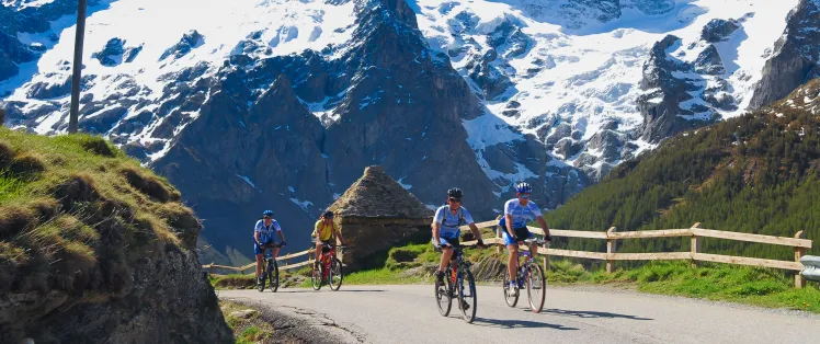
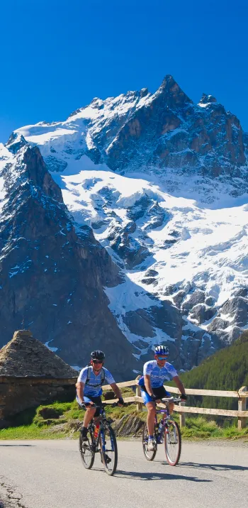
21 times between 1947 and 2022: between the Tour de France and the Col de la Croix-de-Fer, it's an old love story! At an altitude of 2064 m, the Col du Glandon (1922 m) is just a few kilometers from another of the Tour's crowning glories, another link between the Maurienne and Oisans valleys, the Col de la Croix-de-Fer is undoubtedly one of the most beautiful Alpine passes. Ascenting it from the northeast from Saint-Jean-de-Maurienne, or from the south from Le Bourg-d'Oisans, is a must in a cyclist's life.
Cycling up the Croix-de-Fer pass from the north side
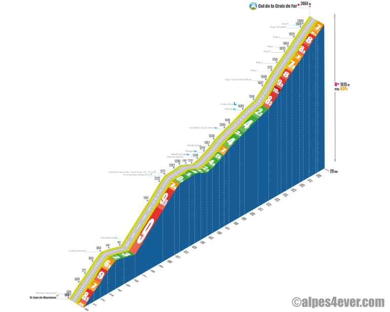
Start : Saint-Jean-de-Maurienne (568 m)
Distance: 29 km
Altitude: 2064 m
Height gain: 1615 m
Average gradient: 6.5%
Maximum gradient: 10.5%
Tour de France® rating: hors catégorie
Time to climb (rounded) the Col de la Croix de Fer by bike via the north side
- At 7 km/h: 4 h 10
- At 11 km/h: 2 h 40
- At 15 km/h : < 2 h 00
- At 19 km/h : 1 h 30
Map of the route up the Col de la Croix de Fer by bike via the north side
Description of the ascent of the Col de la Croix de Fer by bike via the north side
This is a long-distance ascent since it starts 29 km from the summit, in Saint-Jean-de-Maurienne, in the eponymous valley of which this Savoie sub-prefecture is the historic capital. This is the confluence of the Arc and Arvan rivers, which flow down from the Arves valley where the Col de la Croix-de-Fer (2064 m) is located.
To reach this crossing point between the Maurienne valley in Savoie and the Romanche valley in Isère, you need to be in good shape. 1600 meters of D+ at an average of 6.5%, passages at 10% and higher... It's not for nothing that the Croix-de-Fer, so named because of the iron cross at its summit, is a cycling legend.
Here we go...
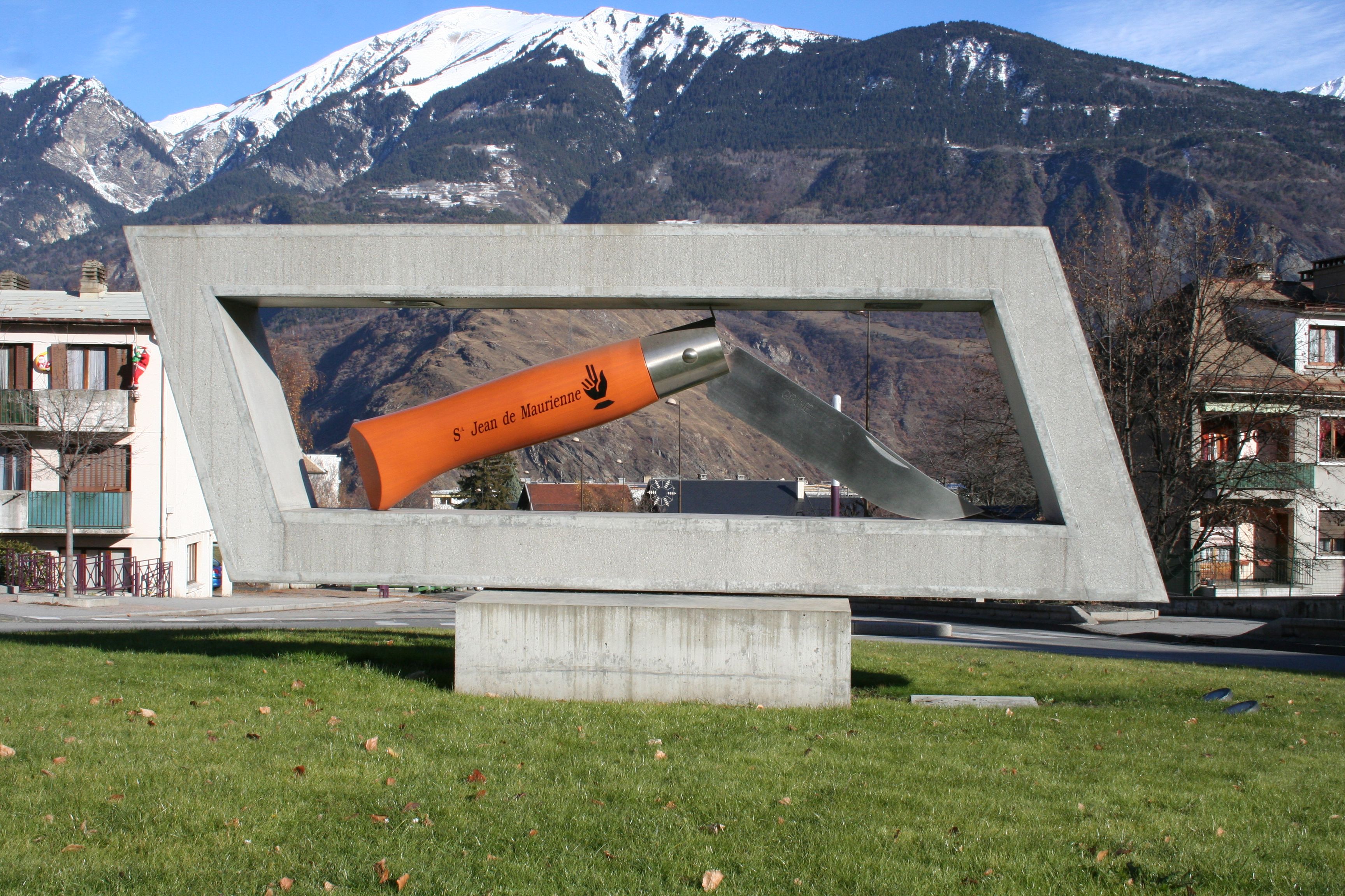
At the Opinel traffic circle, adorned with a statue of the famous knife, the climb officially begins, even though it's been going up for a while already. The first four kilometers, up to the crossroads to the resort of La Toussuire, are marked by steep ramps (up to 9%). You probably won't have time to swerve all the way to La Toussuire, but know that it's a nice 15-kilometre climb (from the crossroads), fairly rolling and with some nice gradients.
But, back to the Col de la Croix-de-Fer... After the La Toussuire crossroads, a two-and-a-half-kilometer descent takes you to the Merderel bridge, immediately followed by just over five kilometers at an average of almost 9%. Very serious stuff!
You then cross three tunnels (96, 178 and 503 meters) between the eleventh and twelfth kilometers, then another descent of around 1.5 kilometers allows you to finish recovering. The next 7.5 kilometers, up to Saint-Jean-d'Arves, then Saint-Sorlin-d'Arves, are very rolling (4 or 5% D+).
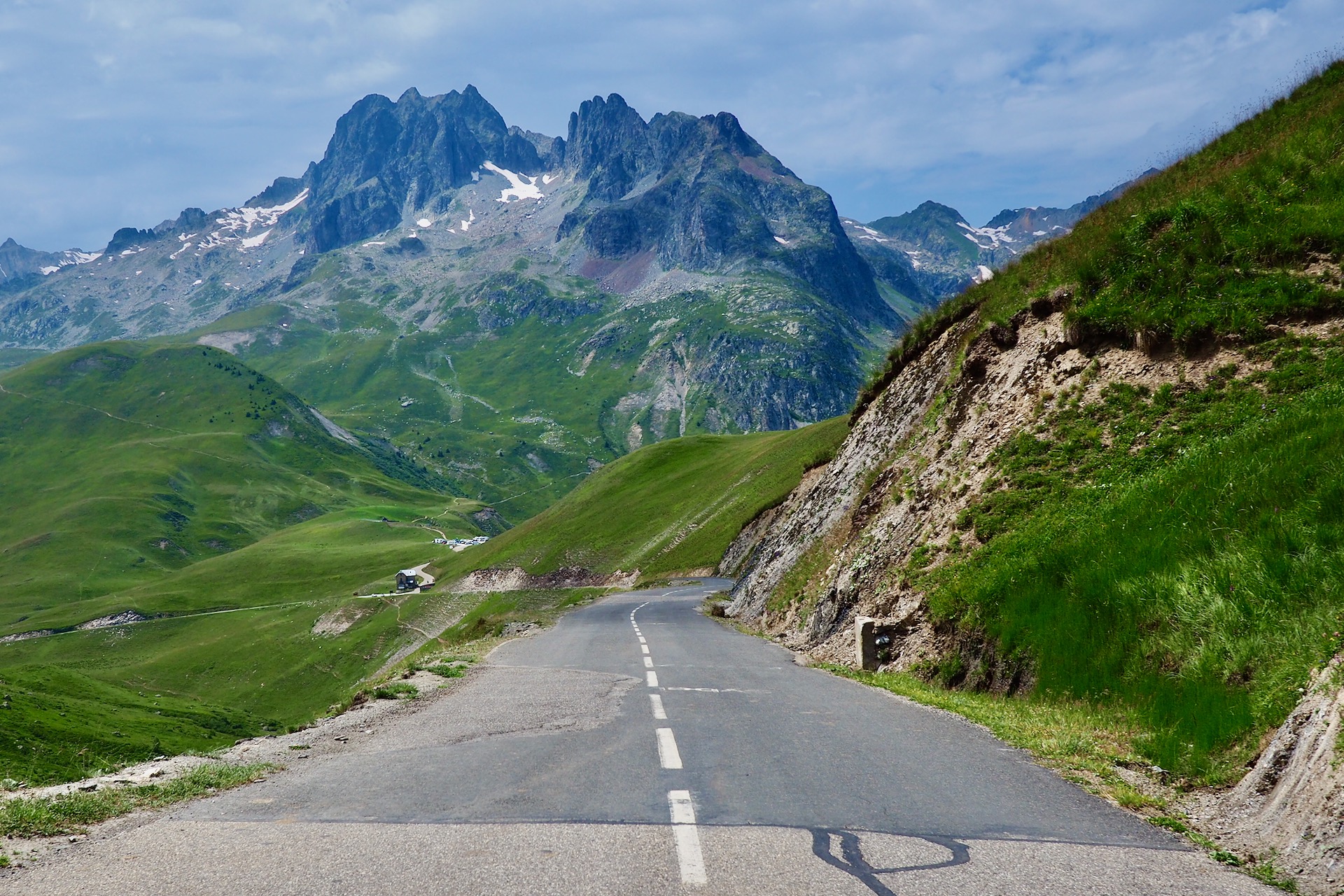
After a flat spot at the entrance to Saint-Sorlin-d'Arves, the final stretch begins: around 6 kilometers at 8 or 9%, with a very steep switchback that posts 12 / 13% for a few meters. The succession of bends leading up to the pass offers incredible views of the upper Arvan valley and the emblematic peaks of the Aiguilles d'Arve.
Arrived at the pass, savor these exceptional landscapes again, before tipping over into the Romanche valley towards the Isère and the Grand'Maison dam and lake, then Bourg-d'Oisans... waiting perhaps for the climb to Alpe-d'Huez.
For completeness, let's mention the very nice variant via the Col du Mollard (1630 m), between Saint-Jean-de-Maurienne and Saint-Sorlin-d'Arves.
Cycling up the Col de la Croix de Fer via the south side
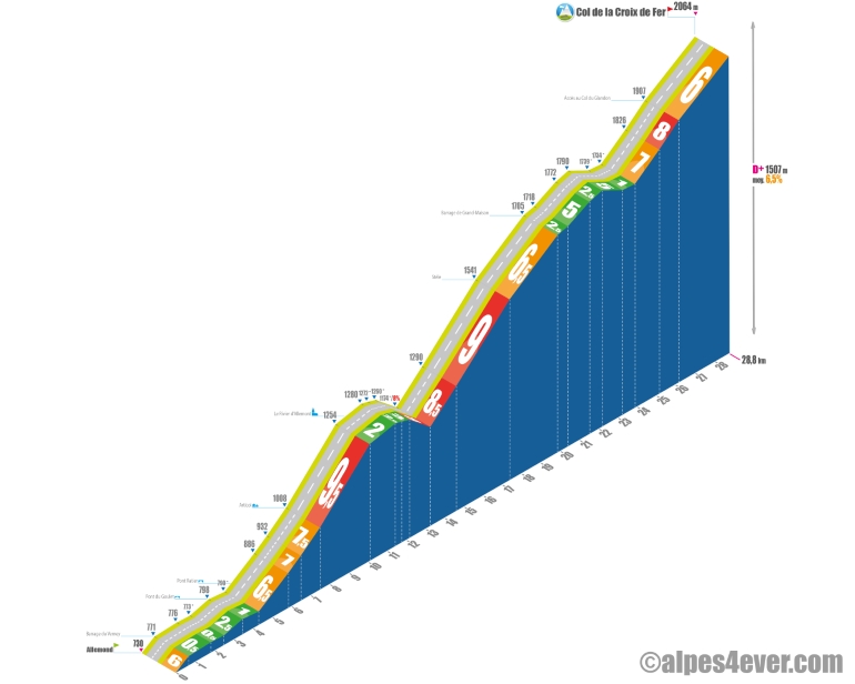
Start : Allemond (730 m)
Distance: 29 km
Altitude: 2064 m
Height gain: 1507 m
Average gradient: 6.5%
Maximum gradient: 11%
Tour de France® rating: hors catégorie
Time to climb the Col de la Croix de Fer by bike via the south side
- At 7 km/h: 4 h 10
- At 11 km/h: 2 h 40
- At 15 km/h : < 2 h 00
- At 19 km/h : 1 h 30
Map of the route up the Col de la Croix de Fer by bike via the south side
Description of the climbing the Col de la Croix de Fer by bike from the south side
If you consider that the ascent only really begins at Allemond (13 km after Le Bourg d'Oisans), we're faced with the same challenge, or more, as on the north side. You'll have to cover almost 29 kilometers for 1500 meters of positive vertical drop before switching to the Maurienne valley side. One of the most beautiful climbs on the Route des Grandes Alpes®, without a doubt!
Alternating difficulties and short descents conducive to recovery, reviews of a few waterfalls, great alpine dams - these are the characteristics of this southern slope.
Starting from Allemond
You start from the foot of the Verney dam, on the Eau d'Olle! A few hundred steep meters, followed by two and a half quiet kilometers along the Lac du Verney. You skirt the Eau d'Olle hydroelectric plant, descend slightly to the Pont Ratier, before starting a little over three kilometers between 6.5 and 7.5% to Articol.
After this hamlet, it gets tougher with 2.5 kilometers in a straight line or almost at 9.5%! Fortunately it's in the shade and followed by a flat area, then a descent of almost two kilometers.
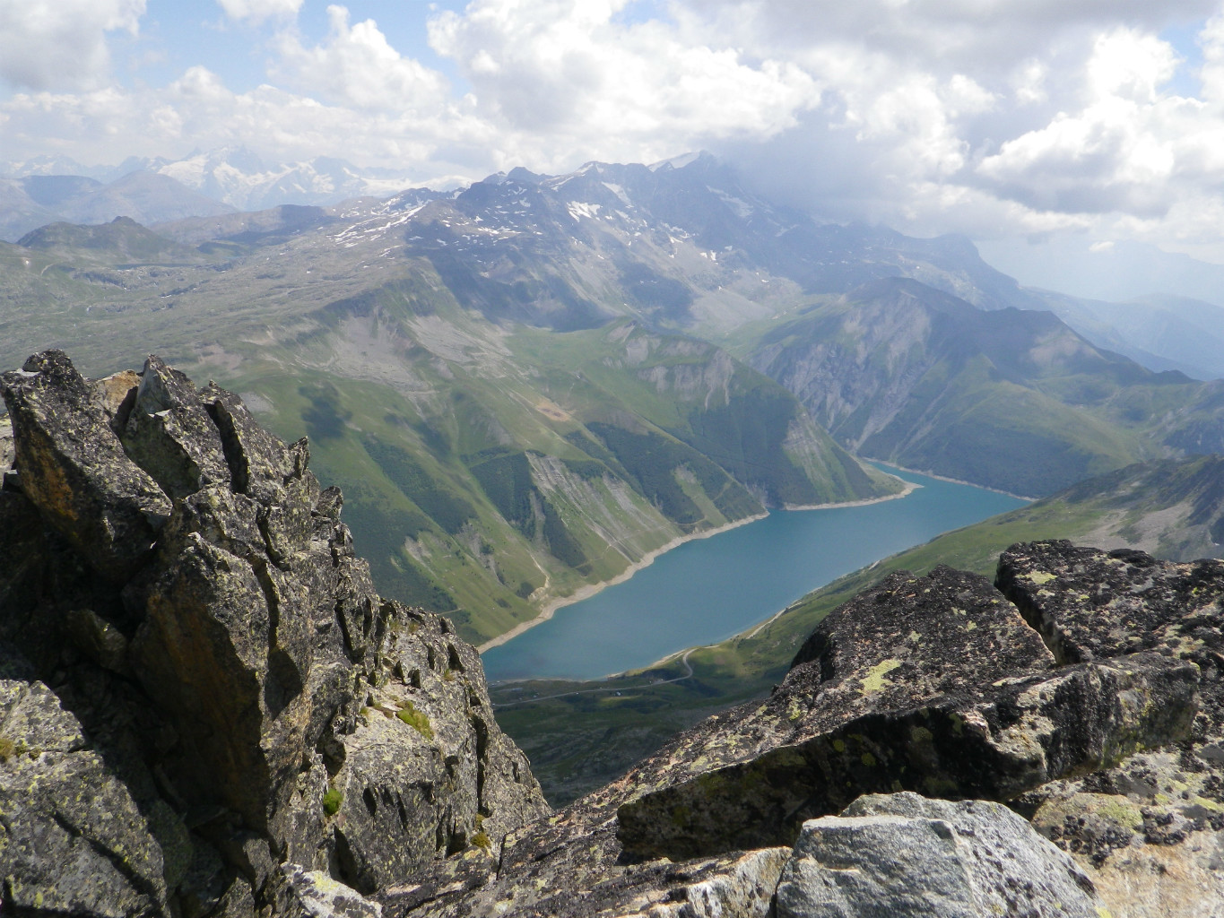
The appetizers are over: you've got over 15 kilometers to go and you're entering the most serious part of the climb. The kilometers that separate you from the Grand-Maison dam offer gradients of up to 11%, with short passages even steeper. It ends more quietly with 2.5 kilometers at 6.5%, followed by a dazzling view of Grand-Maison lake.
You'll be able to enjoy the view to the full, as for over two kilometers the slope will be gentle, even ending with a descent to the border bridge between the Isère and Savoie departments.
Then remain around five kilometers of alpine pastures to the pass. The first half is the hardest, between 7 and 8%. Bonus for pass hunters: you can add the Col du Glandon (1922 m) to your trophy cabinet. It will cost you a very brief round trip at 6.5%.
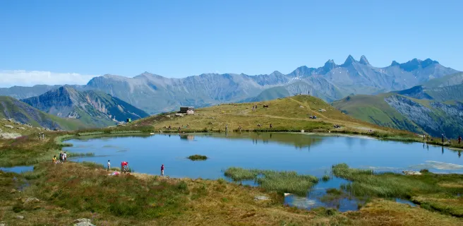
The second half, at 6%, takes you in an armchair or so up to the Col de la Croix-de-Fer. Time for a coffee (at least) facing the marvellous panorama of the Aiguilles d'Arves.
Conseils pour préparer l'ascension du col de la Croix de Fer
The Col de la Croix-de-Fer is one of the great climbs of the Oisans variant, which also offers you the ascent of Alpe-d'Huez and the Col de Sarenne. More than enough to console you if you're forced to use it to bypass other major closed cols!
Our advice:
- Whichever side you're on, it's going to be a long one! So remember to fill up two water bottles before you set off. Don't forget the sunscreen, and leave early, or you'll be in for some heat exhaustion.
- Leave nothing to chance: read the checklist we've prepared for you
- Looking for an expert in bike touring? Check out our partners Vélorizons and La Rébenne. They'll take care of everything for you. Learn more.
- You're thinking of setting off on an electric bike, discover the "VAE : tout comprendre" section, specially written for you.
Weather conditions for the Croix de Fer pass
.jpg)
The Croix-de-Fer pass is generally open from early May to late October.
For weather conditions at the pass, you can consult the meteoblue website.
To find out what time of year to set off on Route des Grandes Alpes ®
Recommended equipment for the Croix de Fer pass
The Croix-de-Fer pass is at an altitude of 2064 meters. This means it can be very hot, very cold or very wet. You need to be prepared for all scenarios, after consulting the weather forecast before setting off.
One of the special features of the Croix-de-Fer is its length. It is therefore particularly recommended that electric bike tourers ensure that their batteries are fully charged before embarking on the climb.
As a general rule, before setting off on Route des Grandes Alpes ®, don't hesitate to fit a cassette that allows you to grind rather than power through. Especially if you're loaded. Also recommended for foodies who, in the north-south direction, would have planned to follow up with the climb to Alpe-d'Huez.
At the risk of repeating ourselves, remember to have a postural study done to adapt your bike to your morphology and limit aches and pains.
Finally, don't forget to check out our practical section
Recharging stations for your electric bike: Bourg d'Oisans.
Services near the Col de la Croix de Fer
At the top of the pass, you can eat or have a coffee at the "Chalet du Col de la Croix de Fer" restaurant.
On the Savoie side, on the north side, between Saint-Jean-de-Maurienne, Saint-Jean-d'Arves and Saint-Sorlin-d'Arves, which is right at the foot of the pass, you'll find a plethora of shops of all kinds.
On the south side, on the Isère side, stock up at Bourg-d'Oisans, or a little further on at Allemond, because after that you won't find anything until you reach the pass.
VAE charging stations : Bourg d'Oisans
Access to the Col de la Croix de Fer
SNCF and bus stations
- Saint-Jean-de-Maurienne
- Grenoble
- Le Bourg-d'Oisans
Road access
- D1091 from Le Bourg-d'Oisans, then D526 to the pass.
- D1091 from Saint-Jean-de-Maurienne to the pass.
Those who have done it speak best of it!
.jpg)
Living near Saint-Jean de Maurienne, I know the north side of the Croix-de-Fer well. I also recommend the climb to La Toussuire, which starts on the pass road. And also the route via the Col du Mollard. Philippe, Saint-Jean de Maurienne.
When you get to Saint-Sorlin d'Arves, you can see that it straightens out and twists and turns all the way to the top of the pass. We know we're going to suffer! Brune, Paris.
Watch out, at weekends, in high summer, when you head back down to Saint-Sorlin. Cars are on touch - touch and force a perilous slalom! Martin, Grenoble.
Started from a small parking lot near the freeway, a few km before St Jean, one morning in late July. Terrible heat, fortunately there were the tunnels to cool off... Jonathan, Annecy.
It's beautiful, changing with occasional descents. But everywhere, incredible panoramic views. Special mention for the Aiguilles d'Arves and their lacework cut out against the sky. Alex, Beauvais.
Chaining Col du Mollard - Col de la Croix de Fer from Saint-Jean-Maurienne on a Tour de L'Oisans in 3 days. Le Mollard (via Villardgondran) is a series of rolling bends in the forest: a real pleasure! As for the Croix de Fer, it's very serious... But the scenery more than makes up for the slope! And the descent to Bourg d'Oisans is an unforgettable slide." Lionel, Co-host of Route des Grandes Alpes ®
FAQ
Why is the Croix-de-Fer pass called that?
Simply, because an iron cross, overlooking a stone monument, has been planted at the top of the pass.
How is the other major pass, immediately adjacent to the Col de la Croix de Fer named?
It's the Col du Glandon (1924 m). It's just three kilometers from the Col de la Croix de Fer and a few dozen meters from Route des Grandes Alpes®. Also located in Savoie, it too forms the junction between the Maurienne and Romanche valleys.
What great dam was built in the Isère département, below the Col de la Croix-de-Fer?
The Grand'Maison dam, which is the most powerful in France! Commissioned in 1987, it is 550 m long and 140 m high, with a storage capacity of 140 million m³ of water, around a hundred of which comes from the annual snowmelt. To find out more about French dams, you can visit the EDF Hydrelec museum, on the shores of Lac du Verney, a little downstream from the Grand'Maison dam. See also our page on large dams.
What are the names of the three characteristically shaped peaks that can be admired from the Col de la Croix-de-Fer?
These are the Aiguilles d'Arves: the aiguille Méridionale (3514 m) straddling the Arves massif and the Oisans, the aiguille Centrale (3513 m) and the aiguille Septentrionale nicknamed "Tête de Chat", because of its characteristic shape. The latter features two summits, the cat's ears: Bec Sud (3358 m) and Bec Nord (3364 m).
The map
The map
17 Alternative stage Saint-Jean-d'Arves / L'Alpe d'Huez
Other passes near the Col de la Croix de Fer
| The most beautiful passes of Route des Grandes Alpes ® |