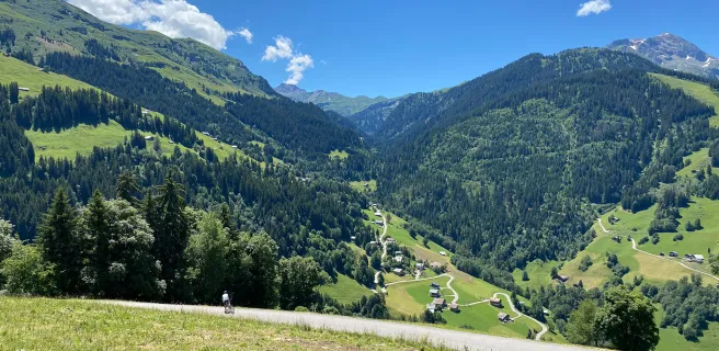
Drooling in a dazzling landscape
Altitude 1968 m
Massif du Beaufortain
Département Savoie
Summary
- Plan your bike ascent of Cormet de Roselend
- Bike up Cormet de Roselend from Beaufort-sur-Doron, by the north side
- Description of the ascent of the Cormet de Roselend by bike from Beaufort-sur-Doron, by the north side
- Cycling up the Cormet de Roselend from Bourg-Saint-Maurice, by the south side
- Description of the Cormet de Roselend cycling ascent from Bourg-Saint-Maurice, by the south side
- Advice to prepare for the ascent of the Cormet de Roselend
- Weather conditions for the Cormet de Roselend
- Recommended equipment for the Cormet de Roselend
- Services at the Cormet de Roselend
- Access to Cormet de Roselend
- Témoignages
- FAQ
Plan your bike ascent of Le Cormet de Roselend
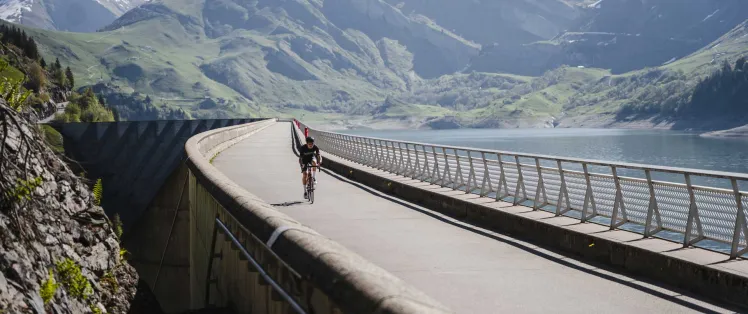
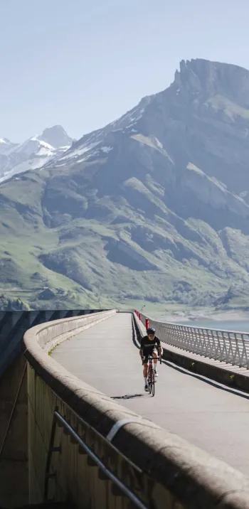
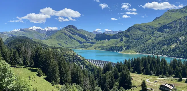
Located at 1968 m above sea level, this col on Route des Grandes Alpes ® links Beaufort-sur-Doron to Bourg-Saint-Maurice and the Beaufortain to the Tarentaise valley. This ascent, which takes place in splendid scenery, allows us to admire the reservoir of the Roselend dam and its small emblematic chapel. The western slope, from Beaufort-sur-Doron, leaves you with a choice of two options. The "normal route" via the Col de Méraillet (1605 m), the usual stepping stone to Cormet de Roselend, and its variant via Arêches-Beaufort and the dreaded Col du Pré (1703 m), which takes you over the dam itself.
Cycling up the Cormet de Roselend from Beaufort-sur-Doron, via the north side
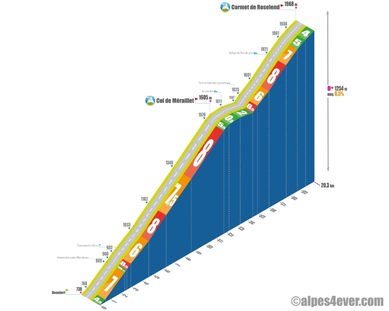
Start: Beaufort-sur-Doron (738 m)
Distance: 20.3 km
Altitude: 1968 m
Height difference: 1230 m
Average gradient: 6%
Maximum gradient: 9.5%
Tour de France® rating: hors catégorie
Time to climb (rounded) Le Cormet de Roselend by bike from Beaufort-sur-Doron, via the north side
- At 7 km/h: 2 h 55
- At 11 km/h: 1 h 50
- At 15 km/h : 1 h 20
- At 19 km/h : 1 h 05
Map of the Cormet de Roselend ascent by bike from Beaufort-sur-Doron, via the north side
Description of the ascent of Cormet de Roselend by bike from Beaufort-sur-Doron, by the north side
Let's start by setting the scene! You're in Beaufort and, to reach Lac de Roselend, the stepping stone to Le Cormet de Roselend, you're hesitating between the normal route and the variant via the col du Pré(1703 m).
If you're feeling particularly strong, don't hesitate to head for Arêches and encaper the ascent to Col du Pré.
If you're feeling good, or even very good, but don't particularly feel like cutting open your belly, we recommend the classic, already very difficult route. To take this road, which leads to the Col de Méraillet (1605 m) and commands access to Lac de Roselend, the intermediate stage of the Cormet de Roselend ascent, leave Beaufort along the Doron river, heading east.
What awaits you up to the lake is a dozen kilometers, first along the torrent and then as it twists and turns, at an average of just over 7% with passages above 8%. The climb, through the forest, is steady. Apart from the passage through the hamlet of Fontanus, there are no passages flat enough to recover even a little.
A beautiful "bavante", which only flattens out on reaching the Col de Méraillet, where precisely the Col du Pré variant arrives...

Par le col du Pré (1703 m)
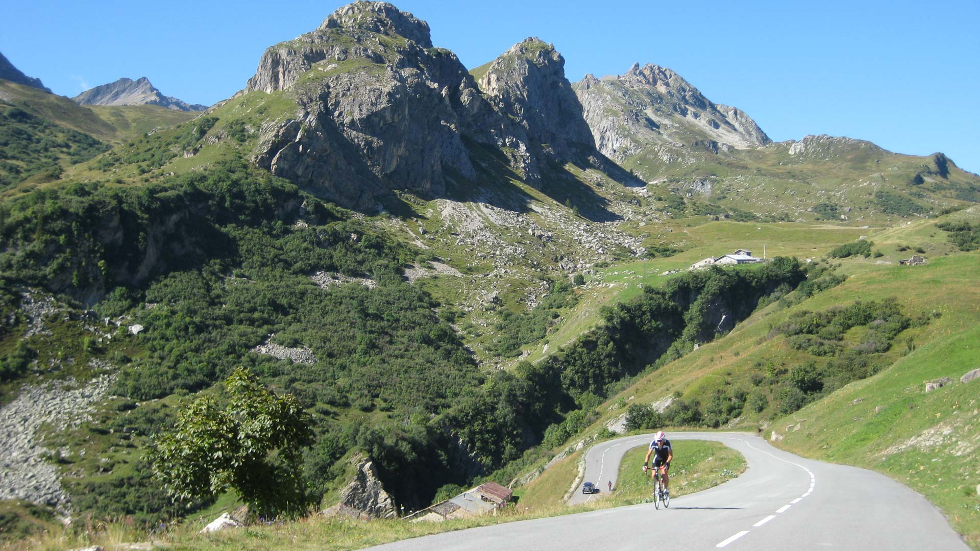
The ascent of the col du Pré, too, is around 12 kilometers for just under 1000 meters of ascent, with an average D+ of around 8%. The first five kilometers correspond to the distance between Beaufort and the exit of the charming village of Arêches. With the exception of two brief bursts of ass, they are fairly moderate. It's after this that the going gets really tough, as you'll find passages of over 10, even 11%, in the last two-thirds of the climb.
After Arêches, some fifteen hairpin bends, between 8 and 10%, take you above the hamlet of Boudin, then its parking lot. Then comes the last hairpin bend and a short straight section, due east, to the Col du Pré. From the Col du Pré to the Col de Méraillet, you have 4.5 km to go, with no difficulties until you reach the Roselend dam, which you'll have the pleasure of crossing by bike. Then you cycle along the reservoir to the Col de Méraillet and the Chalet de Roselend where, if you wish, you can refresh yourself.
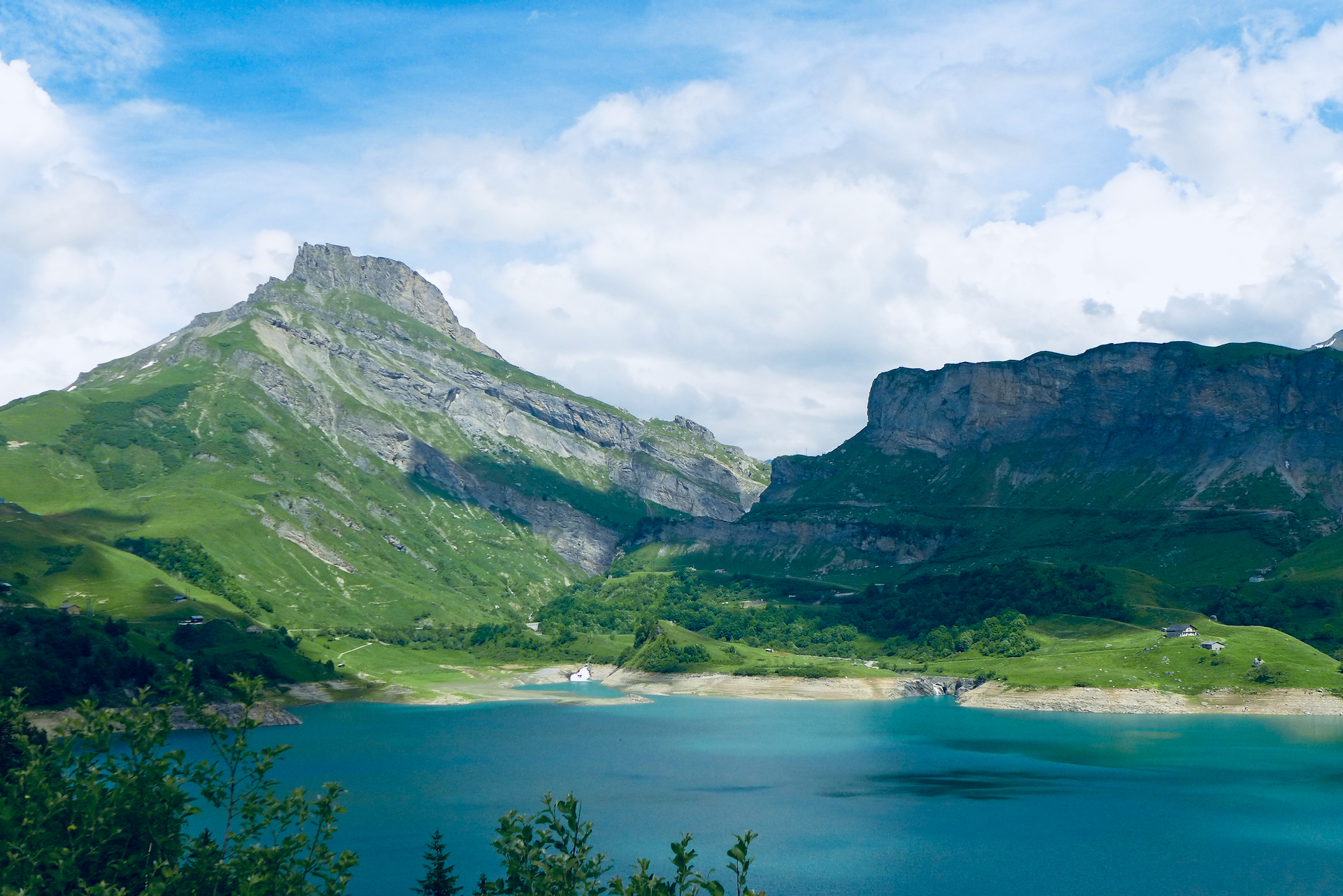
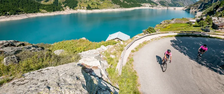
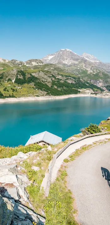
From Lac de Roselend to Cormet de Roselend
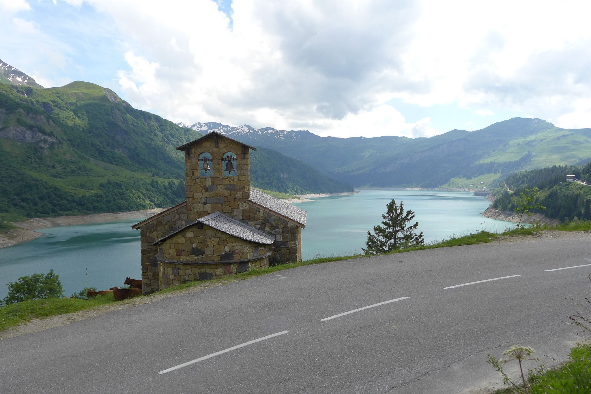
Whether you've climbed via the normal route or the Col des Prés, there are 7 kilometers left before the summit. Before you set off, take time to admire the exceptional scenery before you: the most beautiful dam in Savoie, the turquoise waters of Lac de Roselend, the little chapel, the sumptuous mountain pastures, the exceptional views...
But it's time to tear yourself away from contemplation and reach the highest mountain pastures. It starts off well: almost two kilometers of tranquility and even descent along the lake before crossing to the other side and starting to climb. You then enter the realm of the high mountains, and breathing becomes a little more difficult. We're not going to lie to you, there are still some slightly "hard" sections above 8%.
Divine surprise, the final section is very rolling and, if you've still got it, you'll finish at full speed. It's exhilarating!
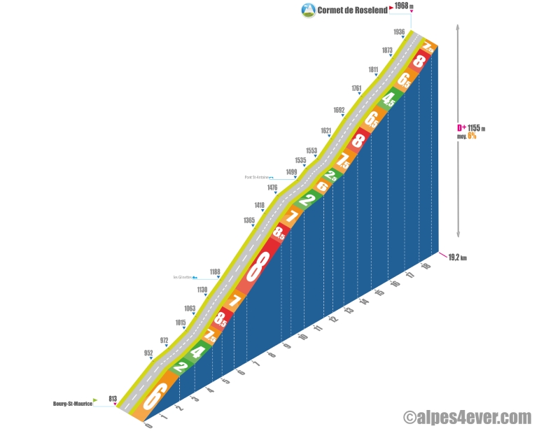
Cormet de Roselend ascent by bike from Bourg-Saint-Maurice, via the south side
Start: Bourg-Saint-Maurice (815 m)
Distance: 19.3 km
Altitude: 1938 m
Elevation: 1150 m
Average gradient: 6%
Maximum gradient: 9%
Tour de France® rating: hors catégorie
Time to climb Cormet de Roselend by bike from Bourg-Saint-Maurice, by the south side
- At 7 km/h: 2 h 45
- At 11 km/h : 1 h 45
- At 15 km/h : 1 h 15
- At 19 km/h : 1 h 00
Map of the route up the Cormet de Roselend by bike from Bourg-Saint-Maurice, via the south side
Description of the ascent of Cormet de Roselend by bike from Bourg-Saint-Maurice, by the south side
The route stretches for around 19.3 kilometers, with a positive vertical drop of around 1,250 meters, for an average of 6.1% D+. The difficulty of this ascent is more or less the same as on the other side of the mountain, but more regular. In fact, this pass is climbed in stages, alternating sections at 8% with flatter sections allowing you to recover. The mountainous terrain and dense surrounding forest partially limit the view, reserving the big show for the summit and the magnificent descent to the dam and Lake Roselend.
The first five kilometers aren't too mean. The start of the climb is a 2.4-kilometer ramp at 6%, which rises quickly to Le Châtelard, just outside the town, offering a beautiful perspective on Bourg-Saint-Maurice. A breathtaking view of the Aiguille du Clapet (2615 m) is revealed on the right. The slightly uphill road then turns north into a steep valley along the Versoyen river towards Bonneval-les-Bains, a former spa resort at an altitude of 1063 m.
At this point, the serious difficulties begin. For just under two kilometers, the gradient rises to 8.5%, then 7% up to Les Glinettes. You then face three tough kilometers, including a series of nine short hairpin bends at 8%, followed by a sustained slope of 7% for 850 meters. A brief descent below Crêt Bettex marks the entrance to the Vallée des Chapieux, offering a welcome breath of fresh air.
At this point, you've covered just over half the climb and continue your progress for two and a half kilometers through spectacular scenery. A long uphill false flat, punctuated by a short 600-meter climb at 6%, past the Pont St-Antoine, allows you to continue your recovery.
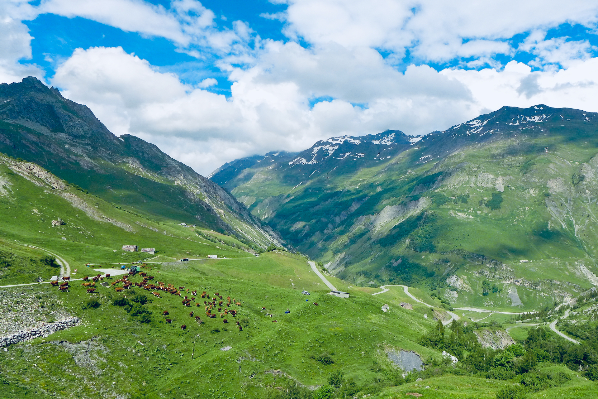
To the northeast, the Aiguille des Glaciers (3816 m), one of the last peaks in the Mont-Blanc massif, dominates the border ridge between France and Italy. You can admire the whiteness of its glacier, from the access to the hamlet of Les Chapieux, which marks the start of the last part of the route, some 6 kilometers.
After climbing almost two kilometers at 7.5/8%, a further kilometer of not too nasty tight bends at 6.5% D+ takes you due west. The road continues in a straight line, with a gentle gradient of 4.5% for just over a kilometer. You then enter the long 2.2-kilometer curve, with sections at 6.6%, 8% and 7.5%, which leads to the summit. This section can be tricky if there's a strong headwind!
No coffee at the finish (1968 m), you'll have to make your way up to Chalet de Roselend, after a breathtaking descent through alpine meadows and over Lac de Roselend.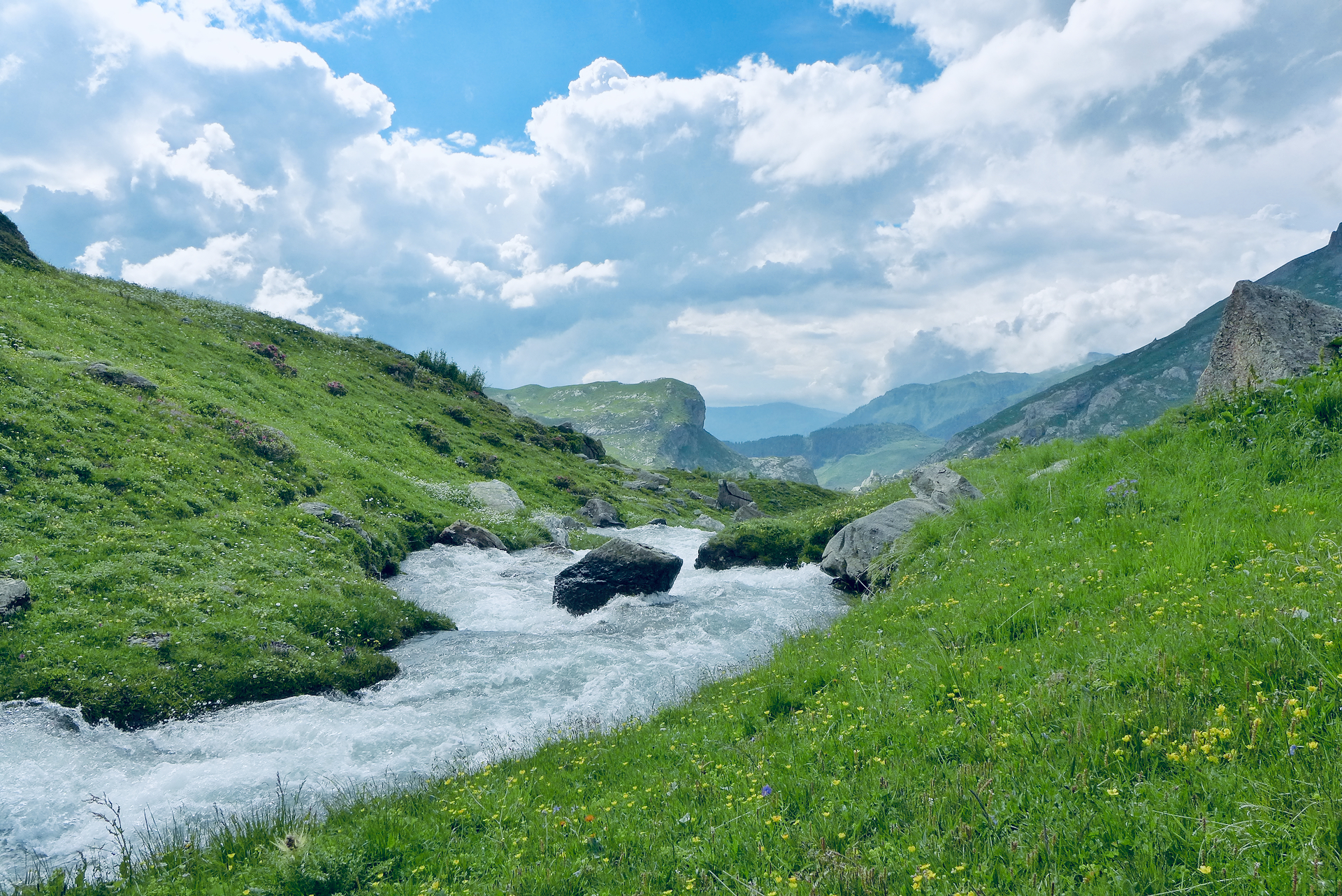
Conseils pour préparer l'ascension du Cormet de Roselend
During the 1996 Tour de France, Belgian rider Johan Bruyneel missed a left turn on the descent of the Cormet de Roselend, heading towards Bourg-Saint-Maurice. He did an "all-right" and disappeared into a ravine, from which he emerged miraculously unharmed a short time later. This emblematic fall is a reminder to be extra careful when descending passes!
Our advice:
- Le Cormet de Roselend is very close to the Mont-Blanc massif and its glaciers. This is the Northern Alps, and the weather can be very cold. The wind can be strong and the bad weather sudden and violent. Above all, bring warm, waterproof clothing.
- Why not go with a specialist travel agency, which takes care of all the logistics for you: luggage transport, accommodation booking, possibly accompaniment and bike rental... Discover which specialist to go with on Route des Grandes Alpes®
- Your bike and personal equipment must be carefully chosen, prepared and maintained: discover the equipment you'll need for the Route des Grandes Alpes®
Weather conditions for the Cormet de Roselend
The Cormet de Roselend flirts with the 2,000 m mark without actually reaching it. Even so, it can be cold, even in the height of summer, especially at the summit when the wind is blowing hard. For example, during the Cluses - Tignes stage of the Tour de France 2021 on July 04, the riders endured appalling conditions on the ascent and summit of the Cormet de Roselend.
The Cormet de Roselend is often open from early June to late October. If you're heading out early in the season, make sure the pass is open and the roads are passable. The Col du Méraillet - Col du Pré loop can be done earlier in the season (early May).
To check road conditions and pass opening, visit savoie-route.fr (check "État des cols" under "Données cartographiques") or call the tourist offices in Beaufort or Bourg-Saint-Maurice (Savoie).
To check weather conditions on the Cormet de Roselend, consult this site.
To find out when to go on Route des Grandes Alpes ®
Recommended equipment for the Cormet de Roselend
Get yourself some warm, windproof clothing. You'll need them for the descent... and maybe for the ascent too.
Graving the Cormet de Roselend requires a lot of energy, especially with difficult weather conditions. Take what you need to eat and hydrate regularly.
Have you had a postural study carried out to adapt your bike to your morphology and avoid wear and tear little bobos? It's on this type of climb that you realize the importance of meticulous preparation.
If you're on an EAB, be sure to check your battery charge before you set off to avoid running out of power! Thanks to the electrically-assisted bicycle (VAE), Route des Grandes Alpes® has become accessible to a greater number, if not the greatest number. Choosing your electric bike shouldn't be left to chance: see our section

A bike for travel at a low price?
Alltricks offers a new range of reconditioned bikes to get well equipped at low prices!
Find a selection of Road - Gravel bikes suitable for Route des Grandes Alpes by clicking here!
Services at Cormet de Roselend
At Beaufort-sur-Doron (west side), Arêches-sur-Beaufort (Col du Pré variant) and Bourg-Saint-Maurice, you'll find all the useful services you need for your trip: accommodation, catering, supplies, bike repair and hire...
No cafés or restaurants at the top of the pass. Instead, you can stop off at the Refuge du Plan de la Lai, or the Chalet de Roselend, near the lake of the same name.
Access to Cormet de Roselend
SNCF railway stations and bus stations
- Albertville
- Bourg-Saint-Maurice
- Beaufort-sur-Doron
Road access
- D925 from Albertville (A43).
- D212 from Ugine and the Arve valley (A40).
- D902 from Bourg-Saint-Maurice (N90).
Those who have done it speak best of it!
My best memories include climbing the Cormet de Roselend and the Col de l'Iseran for their grandiose scenery. Louan Gourdel
Among my favorite passes, the Cormet de Roselend for its sublime lake. Romain
My best memory is passing the Roselend dam. I love this place, which is magnificent. Ludovic Garbit
My best memory: the climb up Cormet de Roselend from Bourg St Maurice to Beaufort. A magical climb through the forest, a sublime plateau, a second part of the pass shared with other cyclists and a superb descent. Cyrille Papon
My best memory of Lac de Roselend because it's so magnificent.... Caroline Hiebel with Lucie and Thierry
Number 1, the Cormet de Roselend, from Bourg-St-Maurice. Magnificent! Just after the Petit Saint-Bernard in our Mont-Blanc tour. Marc and Jean-Marc
On the way to Cormet de Roselend, the complicated Col du Pré, with its magnificent view of the Roselend dam. Éric Aussant
In three, I'd put Cormet de Roselend and Iseran tied, despite the incredibly complicated weather conditions we encountered there. Gérard Marion-Gallois
Graced during my South-North Alps crossing in 2022, the South side of the Cormet de Roselend is a magnificent mountain biking experience. It's all there: forests, torrents, alpine meadows, glaciers, hairpins and sumptuous panoramas! Lionel Terrail, Co-animateur de Route des Grandes Alpes ®
FAQ
Why "Cormet" de Roselend rather than "col" de Roselend?
"Cormet", means "pass" in Beaufortain patois. There's also Cormet d'Arêches, a little to the south of Cormet de Roselend and almost at the foot of the Pierra Menta. "Cormet" comes from the Latin "culmen" (summit), meaning the end of a valley, where it communicates with the other side.
What is the origin of the little chapel on the shores of Lac de Roselend?
With the hamlet of Roselend swallowed up by the waters of the dam on May 06, 1960, a centuries-old Romanesque chapel disappeared. Rebuilt in a more modern style in 1962, it has become the emblem of this wonderful site and one of the postcards of Route des Grandes Alpes®.
What's the most difficult route up Cormet de Roselend, from Beaufort?
FromBeaufort-sur-Doron, you have a choice of two "stepping stone" passes to the Cormet de Roselend: the Col de Méraillet and the Col du Pré. Both provide access to Lac de Roselend (the Col du Pré variant even passes over the Roselend dam). At 12.2 km and an average D+ of 8%, the Col du Pré is more difficult.
What cheese can be found on either side of the Cormet de Roselend?
The Beaufort, an AOP (Appellation d'Origine Protégée), made, as its name suggests, mainly in Beaufortain, Savoie. It's a raw, whole-milk, pressed, cooked cow's milk cheese. To discover the famous wheels of Beaufort (around 40 kg), don't miss a visit to the Coopérative laitière du Beaufortain, in Beaufort-sur-Doron, or the Coopérative laitière de Haute-Tarentaise, in Bourg-Saint-Maurice.
The map
The map
7 Beaufort-sur-Doron / Bourg-Saint-Maurice
6 Arêches / Bourg-Saint-Maurice
Other passes near Le Cormet de RoselendCol des Saisies | The most beautiful passes of Route des Grandes Alpes ® |