


Linking the Northern and Southern Alps
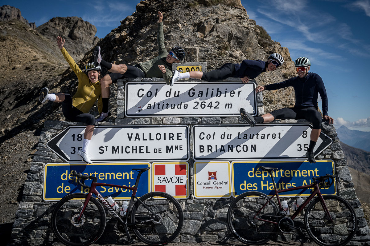
Altitude 2642 m
Massifs des Arves et des Cerces
Départements Savoie and Hautes-Alpes
Summary
- Plan your bike ascent of the Col du Galibier
- Bike up the Col du Galibier from Valloire, by the north side
- Description of the bike ascent of the Col du Galibier from Valloire, by the north side
- Check out the Col du Galibier by bike from the Col du Lautaret, by the south side
- Check out the Col du Galibier by bike from the Col du Lautaret, by the north side
- Conseils pour préparer l'ascension du col du Galibier
- Weather conditions for the Col du Galibier
- Recommended equipment for the Col du Galibier
- Services at the Col du Galibier
- Access to the Col du Galibier
- Témoignages
- FAQ
Plan your bike ascent of the Col du Galibier
This col sur Route des Grandes Alpes ® belongs to cycling legend. From the Maurienne valley (Savoie), via the Col du Télégraphe and Valloire, or from Briançon (Hautes Alpes) via the Col du Lautaret road, the bicycle ascent of the Col du Galibier is one of the jewels of the Tour de France®.
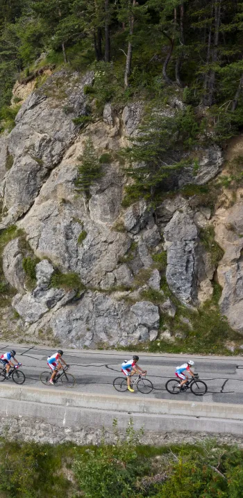
Cycling up the Col du Galibier from Valloire, via the north side
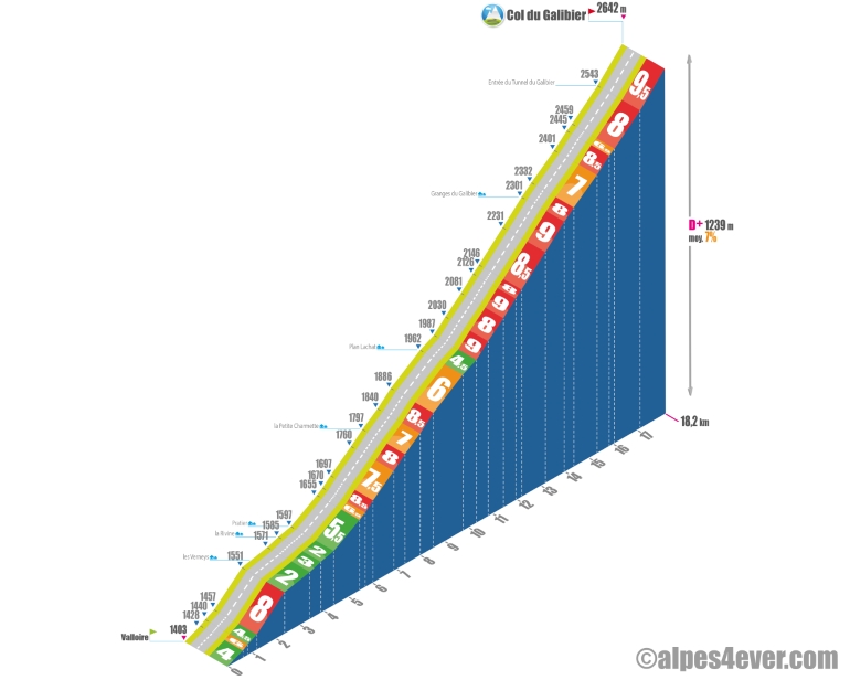 Start: Valloire-Galibier (1403 m)
Distance: 18.2 km
Altitude: 2642 m
Elevation: 1239 m
Average gradient: 7%
Maximum gradient: 9.5% over 1 km
Tour de France rating: hors catégorie
Time to climb (rounded) Col du Galibier by bike from Valloire, via the north side
- At 7 km/h: 2 h 30
- At 11 km/h: 1 hr 36
- At 15 km/h: 1 hr 10
- At 19 km/h: 55min
Map of the route up the Col du Galibier by bike from Valloire, via the north side
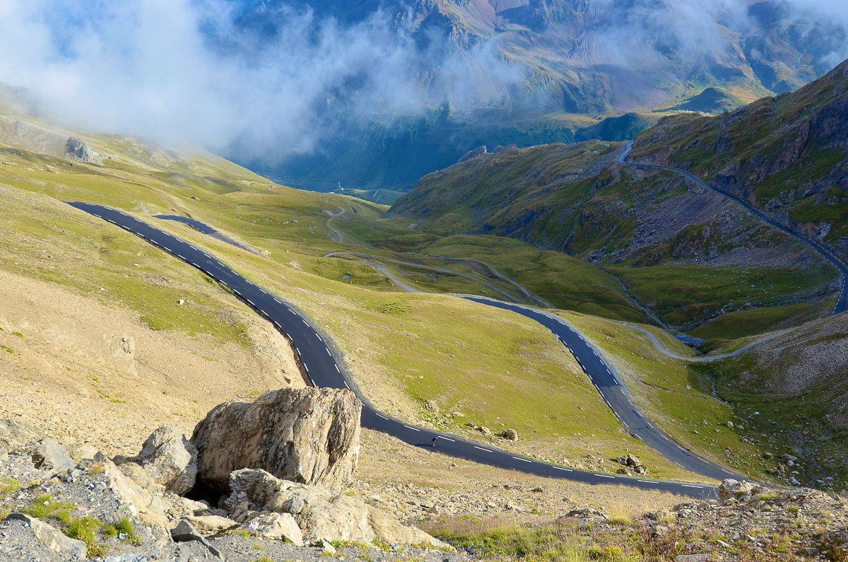
Description of the ascent of the Col du Galibier by bike from Valloire, by the north side
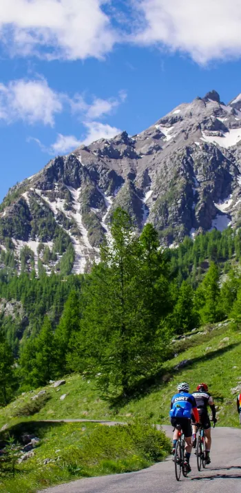
It was in 1911, during the Chamonix - Grenoble stage, that Henri Desgrange, founder of the Tour de France, first sent his riders up the Col du Galibier via Saint-Michel-de-Maurienne, the Col du Télégraphe and Valloire. Today, while Henri Desgrange has his stele on the south-facing slope towards the Col du Lautaret, the ascent of the Galibier via the north-facing slope remains one of the most memorable and third-highest on the Route des Grandes Alpes ®. But the view from the summit, at an altitude of 2642 m in a sometimes very cold atmosphere, justifies hurting yourself for 18.2 km from Valloire, or 34.9 km from Saint-Michel-de-Maurienne and the Col du Télégraphe.
From Valloire, the climb represents 1239 m of D+, at 7% average. Leaving the village, the route follows the Valloirette and remains almost straight until Plan Lachat. Apart from an 8% gradient at Les Verneys, shortly after the start, the gradient remains gentle until the fifth kilometer. The next four kilometers, up to Plan Lachat, are steeper. All in all, these first ten kilometers can prove to be wearisome, especially with a headwind.
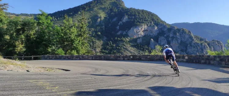
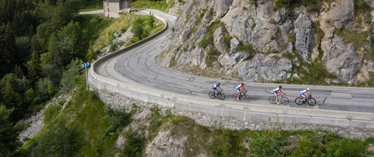
It's at Plan Lachat, on your right, in a suddenly mineral setting that the serious stuff begins, with 7.8 km of ascent at an average of 8.5% to the summit of the pass. The winding slope is very steep for around 4 km, as far as Les Granges du Galibier. Then it eases off briefly and the road becomes straighter. Two kilometers later, it's back to the twists and turns, and back up again!
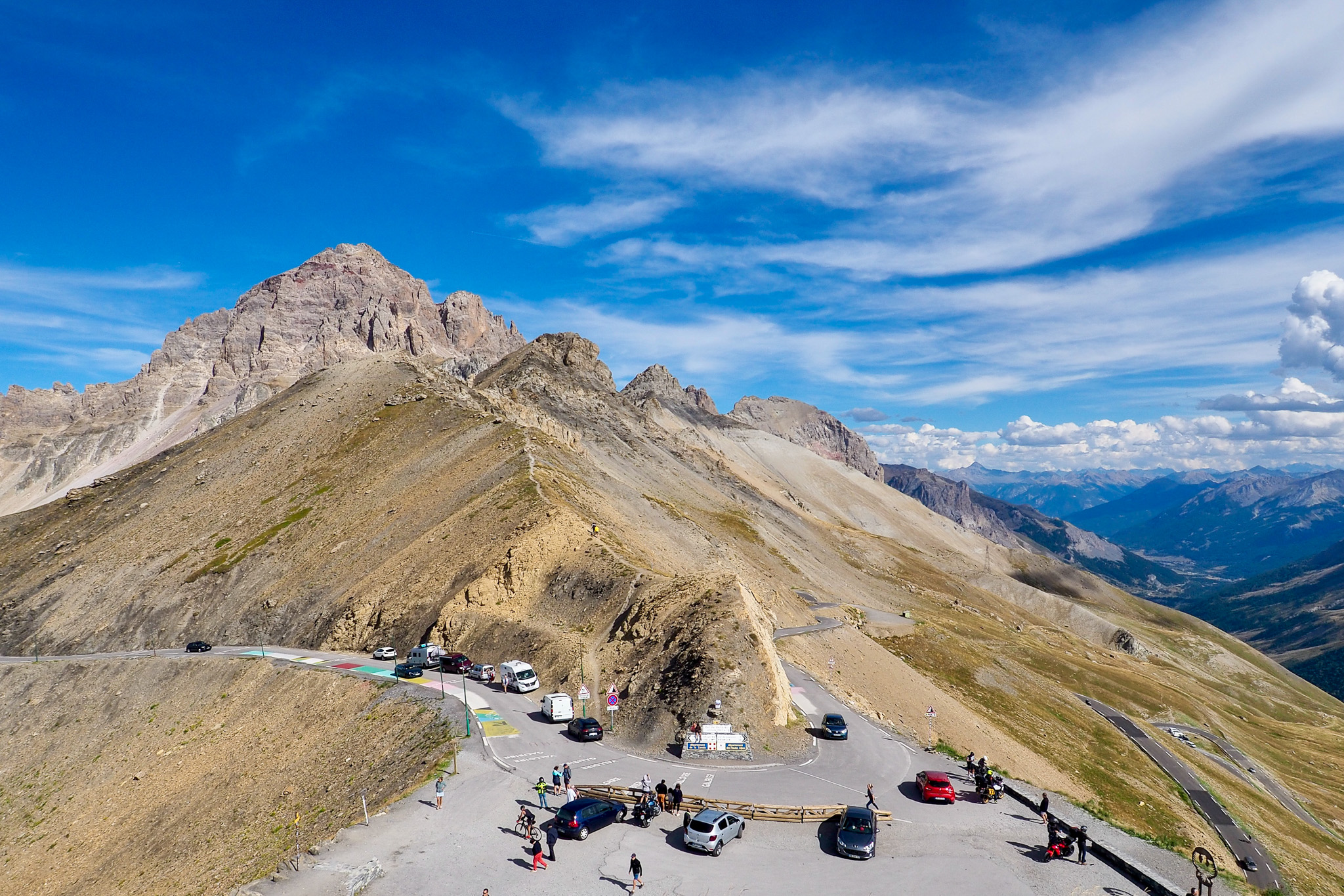
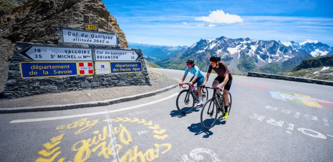
It's tough, but the tunnel isn't so far away. You're not allowed to use it, and to reach the pass, you'll have to climb one last kilometer at 9.5% in a lunar setting and at an altitude where oxygen is starting to become scarce.
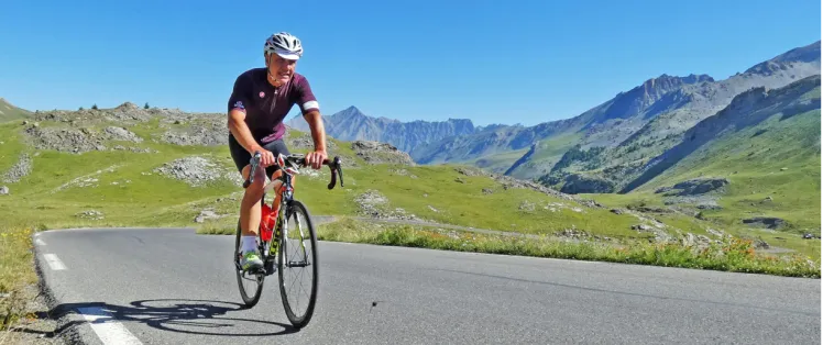
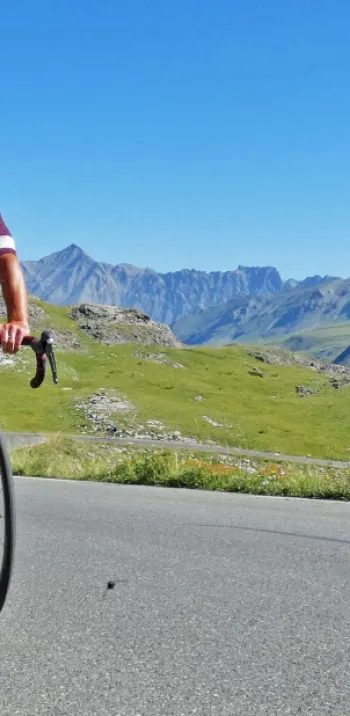
If from Plan Lachat the road overlooking the Valloirette valley has offered you exceptional views, the most beautiful awaits you at the summit. Behind you, the mountains and glaciers of Savoie and Haute-Savoie with, if the weather is clear, Mont Blanc in the background. In front of you the Écrins massif, La Meije and its square glacier.
Cycling up the Col du Galibier from the Col du Lautaret, via the south side
 Start: col du Lautaret 2057 m
Distance: 8.6 km
Altitude: 2642 m
Elevation: 585 m
Average gradient: 7%
Maximum gradient: 9.5% at the last km
Tour de France rating: hors catégorie
Time to climb the Col du Galibier by bike from the Col du Lautaret, via the south side
- At 7 km/h: 1 h 14
- At 11 km/h: 47'
- At 15 km/h: 35'
- At 19 km/h: 27'
Map of the route up the Col du Galibier by bike from the Col du Lautaret, via the south side
Description of the ascent of the Col du Galibier by bike from the Col du Lautaret, by the south side
585 meters of ascent, 8.6 kilometers at 7% average gradient... Even if the last kilometer, which starts at the Henri Desgranges memorial, is 9.5%, this is not the most difficult climb! It's not too bad either if you've previously climbed the Col du Lautaret from Briançon (26 kilometers in total anyway).
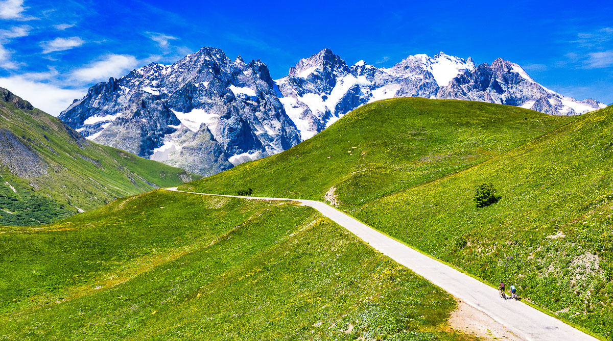
From the Col du Lautaret, you gradually gain altitude amid the alpine meadows. The landscape becomes increasingly mineral as you approach the famous tunnel, which marks the start of the last kilometer: three painful laces for the muscles!
Conseils pour préparer l'ascension du col du Galibier
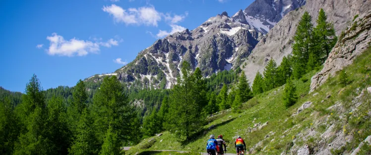
The Col du Galibier is not to be undertaken lightly. The steep gradient, the weather conditions, the altitude which makes breathing more difficult... everything points to the need for serious physical and even psychological preparation. This preliminary remark is even more valid if you chain two passes: Télégraphe - Galibier on the north side, Lautaret - Galibier on the south side.
Our advice:
- If you don't "feel" like it without assistance, set off with a specialist who will organize everything for you: carrying luggage, booking accommodation, possibly accompanying you and renting a bike... We recommend Vélorizons and LaRébenne. Discover which specialist to go with on Route des Grandes Alpes ®
- Go with quality equipment: bike and personal gear. Discover the equipment you need for the Route des Grandes Alpes ®.
- Pay close attention to the weather forecast: you can go from heatwave to bitter cold in no time. In any case, dress for the descent!
- From the tunnel to the pass, and on both sides, the road is narrow. So watch out for traffic: cars, motorcycles, camper vans, etc.
Weather conditions for the Col du Galibier
If you're heading out early in the season, make sure the pass is open and the roads are passable. You can consult savoie-route.fr (check "État des cols" under "Données cartographiques") or call the tourist offices in Valloire (Savoie), Briançon (Hautes-Alpes).
The Col du Galibier is generally open from June to September, sometimes a little longer. Nonetheless, its ascent takes place partly in the high mountains, with risks of violent thunderstorms, heavy rain and even snow. Conditions can change rapidly from one extreme to the next, and if you're not equipped for the cold, the experience can be very trying, especially on the way down! So have the weather reflex: www.meteoradar.com/col-du-galibier.
To find out what time of year to set off on Route des Grandes Alpes ®
Recommended equipment for the Col du Galibier
Don't set off unless you're sure you've got enough water! You can get hot, even very hot on the climb, and on the north side there aren't really any water points after Valloire. So don't forget to fill up two water bottles. It's a great opportunity to take the pulse of this super-friendly resort on a café terrace.
Pack a few energy bars: the climb is calorie-hungry. You'll need to eat regularly. Please note that there are no cafés or restaurants at the top of the Col du Galibier, as there are on other cols. Local refreshment and comfort on the south side only, at the Refuge du Galibier, near the entrance to the tunnel.
Keep in mind that there can be a significant temperature amplitude between the top and bottom of the pass. If you're on an electric bike, make sure your battery is sufficiently charged. Run out of power on the climb and it's back to square one
Les plus beaux séjours au col du Galibier


Linking the Northern and Southern Alps
Altitude 2642 m
Massifs des Arves et des Cerces
Départements Savoie and Hautes-Alpes
Summary
- Plan your bike ascent of the Col du Galibier
- Bike up the Col du Galibier from Valloire, by the north side
- Description of the bike ascent of the Col du Galibier from Valloire, by the north side
- Check out the Col du Galibier by bike from the Col du Lautaret, by the south side
- Check out the Col du Galibier by bike from the Col du Lautaret, by the north side
- Conseils pour préparer l'ascension du col du Galibier
- Weather conditions for the Col du Galibier
- Recommended equipment for the Col du Galibier
- Services at the Col du Galibier
- Access to the Col du Galibier
- Témoignages
- FAQ
Plan your bike ascent of the Col du Galibier
This col sur Route des Grandes Alpes ® belongs to cycling legend. From the Maurienne valley (Savoie), via the Col du Télégraphe and Valloire, or from Briançon (Hautes Alpes) via the Col du Lautaret road, the bicycle ascent of the Col du Galibier is one of the jewels of the Tour de France®.
Cycling up the Col du Galibier from Valloire, via the north side
Start: Valloire-Galibier (1403 m)
Distance: 18.2 km
Altitude: 2642 m
Elevation: 1239 m
Average gradient: 7%
Maximum gradient: 9.5% over 1 km
Tour de France rating: hors catégorie
Time to climb (rounded) Col du Galibier by bike from Valloire, via the north side
- At 7 km/h: 2 h 30
- At 11 km/h: 1 hr 36
- At 15 km/h: 1 hr 10
- At 19 km/h: 55min
Map of the route up the Col du Galibier by bike from Valloire, via the north side
Description of the ascent of the Col du Galibier by bike from Valloire, by the north side
It was in 1911, during the Chamonix - Grenoble stage, that Henri Desgrange, founder of the Tour de France, first sent his riders up the Col du Galibier via Saint-Michel-de-Maurienne, the Col du Télégraphe and Valloire. Today, while Henri Desgrange has his stele on the south-facing slope towards the Col du Lautaret, the ascent of the Galibier via the north-facing slope remains one of the most memorable and third-highest on the Route des Grandes Alpes ®. But the view from the summit, at an altitude of 2642 m in a sometimes very cold atmosphere, justifies hurting yourself for 18.2 km from Valloire, or 34.9 km from Saint-Michel-de-Maurienne and the Col du Télégraphe.
From Valloire, the climb represents 1239 m of D+, at 7% average. Leaving the village, the route follows the Valloirette and remains almost straight until Plan Lachat. Apart from an 8% gradient at Les Verneys, shortly after the start, the gradient remains gentle until the fifth kilometer. The next four kilometers, up to Plan Lachat, are steeper. All in all, these first ten kilometers can prove to be wearisome, especially with a headwind.
It's at Plan Lachat, on your right, in a suddenly mineral setting that the serious stuff begins, with 7.8 km of ascent at an average of 8.5% to the summit of the pass. The winding slope is very steep for around 4 km, as far as Les Granges du Galibier. Then it eases off briefly and the road becomes straighter. Two kilometers later, it's back to the twists and turns, and back up again!
It's tough, but the tunnel isn't so far away. You're not allowed to use it, and to reach the pass, you'll have to climb one last kilometer at 9.5% in a lunar setting and at an altitude where oxygen is starting to become scarce.
If from Plan Lachat the road overlooking the Valloirette valley has offered you exceptional views, the most beautiful awaits you at the summit. Behind you, the mountains and glaciers of Savoie and Haute-Savoie with, if the weather is clear, Mont Blanc in the background. In front of you the Écrins massif, La Meije and its square glacier.
Cycling up the Col du Galibier from the Col du Lautaret, via the south side
Start: col du Lautaret 2057 m
Distance: 8.6 km
Altitude: 2642 m
Elevation: 585 m
Average gradient: 7%
Maximum gradient: 9.5% at the last km
Tour de France rating: hors catégorie
Time to climb the Col du Galibier by bike from the Col du Lautaret, via the south side
- At 7 km/h: 1 h 14
- At 11 km/h: 47'
- At 15 km/h: 35'
- At 19 km/h: 27'
Map of the route up the Col du Galibier by bike from the Col du Lautaret, via the south side
Description of the ascent of the Col du Galibier by bike from the Col du Lautaret, by the south side
585 meters of ascent, 8.6 kilometers at 7% average gradient... Even if the last kilometer, which starts at the Henri Desgranges memorial, is 9.5%, this is not the most difficult climb! It's not too bad either if you've previously climbed the Col du Lautaret from Briançon (26 kilometers in total anyway).
From the Col du Lautaret, you gradually gain altitude amid the alpine meadows. The landscape becomes increasingly mineral as you approach the famous tunnel, which marks the start of the last kilometer: three painful laces for the muscles!
Conseils pour préparer l'ascension du col du Galibier
The Col du Galibier is not to be undertaken lightly. The steep gradient, the weather conditions, the altitude which makes breathing more difficult... everything points to the need for serious physical and even psychological preparation. This preliminary remark is even more valid if you chain two passes: Télégraphe - Galibier on the north side, Lautaret - Galibier on the south side.
Our advice:
- If you don't "feel" like it without assistance, set off with a specialist who will organize everything for you: carrying luggage, booking accommodation, possibly accompanying you and renting a bike... We recommend Vélorizons and LaRébenne. Discover which specialist to go with on Route des Grandes Alpes ®
- Go with quality equipment: bike and personal gear. Discover the equipment you need for the Route des Grandes Alpes ®.
- Pay close attention to the weather forecast: you can go from heatwave to bitter cold in no time. In any case, dress for the descent!
- From the tunnel to the pass, and on both sides, the road is narrow. So watch out for traffic: cars, motorcycles, camper vans, etc.
Weather conditions for the Col du Galibier
If you're heading out early in the season, make sure the pass is open and the roads are passable. You can consult savoie-route.fr (check "État des cols" under "Données cartographiques") or call the tourist offices in Valloire (Savoie), Briançon (Hautes-Alpes).
The Col du Galibier is generally open from June to September, sometimes a little longer. Nonetheless, its ascent takes place partly in the high mountains, with risks of violent thunderstorms, heavy rain and even snow. Conditions can change rapidly from one extreme to the next, and if you're not equipped for the cold, the experience can be very trying, especially on the way down! So have the weather reflex: www.meteoradar.com/col-du-galibier.
To find out what time of year to set off on Route des Grandes Alpes ®
Recommended equipment for the Col du Galibier
Don't set off unless you're sure you've got enough water! You can get hot, even very hot on the climb, and on the north side there aren't really any water points after Valloire. So don't forget to fill up two water bottles. It's a great opportunity to take the pulse of this super-friendly resort on a café terrace.
Pack a few energy bars: the climb is calorie-hungry. You'll need to eat regularly. Please note that there are no cafés or restaurants at the top of the Col du Galibier, as there are on other cols. Local refreshment and comfort on the south side only, at the Refuge du Galibier, near the entrance to the tunnel.
Keep in mind that there can be a significant temperature amplitude between the top and bottom of the pass. If you're on an electric bike, make sure your battery is sufficiently charged. Run out of power on the climb and it's back to square one
Découvrez également


Services near the Col du Galibier
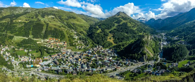
The resort of Valloire, whose full name is Valloire-Galibier, is the undisputed base camp for the Col du Galibier. Here you'll find all the services you need for a successful ascent: accommodation, catering, food shopping, charging points for VAEs, etc.
Southside, you'll find services in Briançon and in the resorts that make up Serre-Chevalier, along the Guisane valley.
Around the pass itself, we recommend a stop at the Refuge du Galibier
This Route des Grandes Alpes ® partner is perched at an altitude of 2556 metres, between the Henri Desgranges monument and the tunnel entrance. Open both summer and winter (ski touring), it welcomes you in a guaranteed family atmosphere. Bar, restaurant, accommodation, nothing is missing at Isa et Sam. Welcome to the Southern Alps!
Access to Col du Galibier
SNCF and bus stations
- Saint-Michel-de-Maurienne (73)
- Modane (73)
- Briançon (05)
Road access
- A43 (73), autoroute de Maurienne, linking the Fréjus Tunnel to the French freeway network.
- RN94 (05), linking Gap to Montgenèvre and providing access to Briançon from France and Italy.
- D1091, linking Grenoble (38) and Briançon (05) at the Col du Lautaret.
Those who have done it speak best of it!
I loved the Col du Lautaret - Col du Galibier sequence for the scenery and the difficulty of the climb. Cyrille Papon
Serious things begin for 1239 m D+ over 18 km at 7%. We move through high mountain landscapes, watched over from above by the Aiguilles d'Arves. We follow the high-altitude Valoirette stream. Our whistling friends always set the mood on the climb, accompanied by mountain flowers, a guaranteed sound and light show. One kilometer before the summit, we have to ignore the tunnel forbidden to cyclists and climb 9% to reach the pass at 2645 m. Caroline Hiebel, with Lucie and Thierry
Le Galibier, for its mythical side. No matter what the level, we all cheer each other on! Benoît Moreau
Many of us have already climbed it, but it's still a special pass before that switchback to the south and Briançon. Pierre Ruelle
Le Galibier (dur dur), a small feat for me. Eric Aussan
FAQ
When can you climb the Col du Galibier?
The Col du Galibier is a very high altitude pass (2642 m). It is generally open from June to early October, and snow is not uncommon during the summer. Its "step" in the Hautes-Alpes, the Col du Lautaret (2057 m), is open all year round. It only closes for a few hours or days, in the event of a snowstorm.
Why is there a tunnel at the top of the Col du Galibier?
The tunnel was bored in 1886 by the military, to make passage easier. The road, built in 1886, was very narrow and often blocked by snow in the last kilometer. After 90 years of loyal service, including for Tour de France riders, the risk of collapse led the authorities to close it in 1976. At the same time, the road to the summit was widened. The tunnel, 370 meters long and 4 meters wide, reopened in 2002, but cyclists were forbidden to use it!
Is the ascent of the Col du Galibier more difficult on the north or south side?
Without hesitation, on the north side, which has a much steeper gradient! This is true of the short version: Valloire - Col du Galibier vs. Col du Lautaret - Col du Galibier. It's even truer in the long version: Saint-Michel de Maurienne - Valloire - col du Galibier vs Briançon (or barrage du Chambon) - col du Lautaret - col du Galibier.
Is the col du Galibier the most difficult of the Route des Grandes Alpes ® passes?
There's no doubt that its northern side belongs to the club of very big passes, alongside the Col de l'Iseran, the Cormet de Roselend, the Col d'Izoard, the Col du Granon, the cime de la Bonette, the climb up to L'Alpe d'Huez, the brand-new giant Col de la Loze and a few other lower-altitude passes such as the Col de Joux-Plane, the Col de la Croix de Fer, or the Col de la Madeleine.
The map
The map
15 Valloire / Briançon
Other passes near the Col du Galibier | The most beautiful passes of Route des Grandes Alpes ® |