


Breathtaking view of the Oisans glaciers
Altitude 2057 m
Massifs des Arves et des Écrins
DepartementHautes-Alpes
Western slope topo
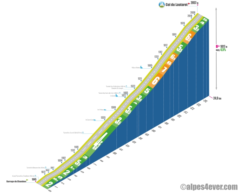
The Col du Lautaret is one of the "2000" that doesn't offer any great difficulty, even if the ascent is long at 25 km and with almost 1000 meters of positive ascent. Take advantage of the viewpoint over the Lac du Chambon dam to take a look at the impressive spillway on the side of the lake.
You'll make your way quietly up the Vallée du Chambon. Take a leisurely ride up the Romanche valley to La Grave. Count on 14.1 km on a gradient of between 0 and 5.5%, with the passage of several (illuminated) tunnels - including the Grand Tunnel du Chambon (966 m) - all in a magnificent setting between the Massif du Galibier-Grandes Rousses and the Massif des Écrins. At La Grave (alt. 1483 m), take the opportunity to catch a glimpse of the imposing summit of La Meije (3983 m).
. On leaving La Grave, you'll take a new tunnel (350 m, fairly narrow, moderately well lit) to the Pont du Maurian.
The slope will remain reasonable as you climb from the top to the bottom. The gradient remains reasonable, rising from 3.5% to 5% until after the last tunnel, the Ardoisières (600 m, moderately well-lit), and then steepens slightly to 6-7% for 6.5 km, but very steadily. Passing through Villar-d'Arêne (alt. 1665 m), the last village before the Col du Lautaret, the scenery is breathtaking. The final stretch is relatively easy, with a 2 km climb from 3.5 to 5%. After a long curve to the left, you reach the Col du Lautaret at 2057 m altitude. The summit is a tourist attraction with a hotel, restaurants and souvenir stores. You can also visit an alpine botanical garden. It's also the access point to the southern side of the Col du Galibier.
Topo east side
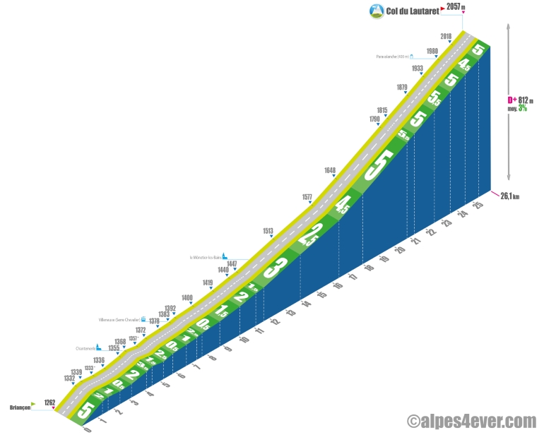
The Col du Lautaret is one of the "2000" that doesn't offer any major difficulties, even if the ascent is long at 26.1 km and with almost 800 meters of positive ascent. From Briançon (alt. 1262 m), the route is fairly straightforward: just head up the Vallée de la Guisane, with a beautiful setting between the Massif des Cerces and the Massif des Écrins, where the road hardly has any twists and turns! For 16.5 km, it's a long upward slope (with the exception of a small bend at the exit from Briançon) with a gradient of no more than 3%. The last 9.5 km have a very regular, medium gradient of around 5%, with a paravalanche (400 m) in the final stretch. Beware: on certain days, the wind can blow into the Vallée de la Guisane, making progress much more difficult.
The map
The map
18 Variante L'Alpe d'Huez / Briançon
Author
Joris Lesueur
webmaster of alpes4ever.com
contact@alpes4ever.com