Ascent to Valberg from Guillaumes
Brice Milbergue Fivefingers.jpeg
From Valberg to Col de la Couillole
Lionel Terrail

Valberg

Beautiful slope, beautiful road

Altitude 1673 m

Massif du Mercantour-Argentera

Département Alpes-Maritimes

Topo versant Ouest

valberg - profil versant ouest

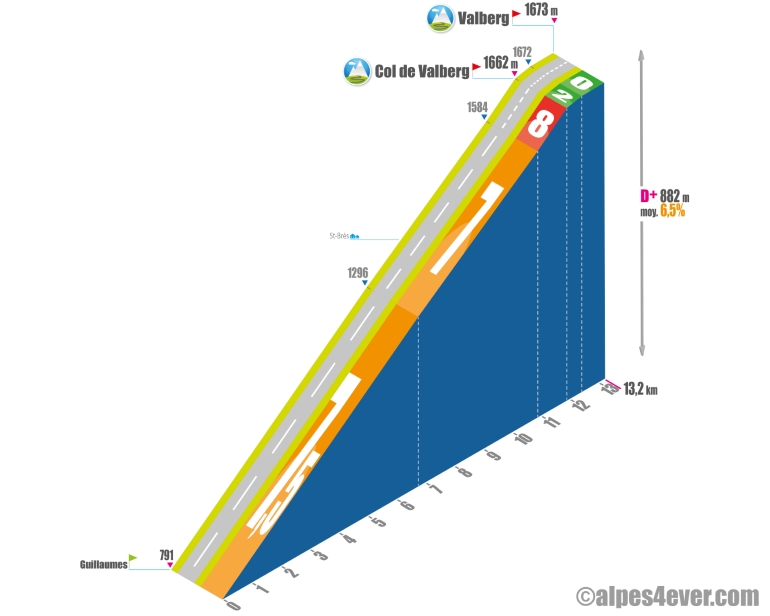
Starting from Guillaumes, it's a 13.2 km climb on an excellent road, with a very regular profile, but wearing at 7-7.5%, with no flat areas to restart. In the final stretch, you'll need to make a 1 km effort at 8% to reach the Col de Valberg - 1662 m. All that's left is a pleasant 1.3 km false flat to reach the Valberg resort.

Versant Ouest via Péone

Starting from Guillaumes, here's another, quieter 14.4 km variant that takes you through Péone. The average gradient will be a little less steep (between 5 and 8%), but won't let you down all the way to Valberg.


Topo versant Est

valberg - profil versant est

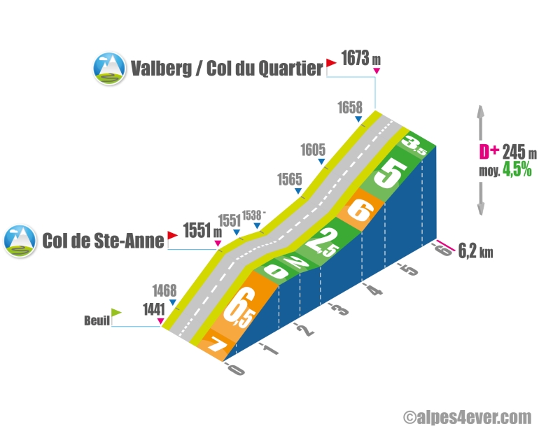
Starting from Beuil, this climb is one of the shortest on the Route des Grandes Alpes at 6.2 km. An initial ramp of 1.6 km at an average gradient of almost 7% takes you up to the Col de Ste-Anne - 1551 m. Then a gentle descent takes you to the foot of the final 1.7 km without too much difficulty - 6% max over 670 m - to Valberg. A little bonus for pass hunters: at the same time, you'll cross the Col du Quartier - 1673 m. Note also that you'll cross the Col de Valberg - 1662 m - at the start of the descent on the opposite side.

The map

The map

Barcelonnette / Valberg

22 Barcelonnette / Valberg

76 km
5 h 00 min
A lovely 77km-long stage that includes taking on the Col de la Cayolle pass (2326m), one of the wildest along the Route des Grandes Alpes®, on the border between the counties of Alpes-de-Haute-Provence and Alpes Maritimes. If cycling south, there’s also the Col de Valberg pass (1671m) to climb, leading to Valberg itself, set in the Haut-Pays Niçois (part of Nice Métropole’s soaring hinterland), a mountain resort that has kept its village feel and been awarded Flocon Vert status for its commitment to sustainable tourism. The landscapes are vast and unspoilt as you cross a portion of the Mercantour National Park; cyclists may be surprised by their austere openness and be tempted to dismount for a little walk. Going down the Val d’Entraunes following the Var River to Guillaumes is a pure delight.
Valberg / Saint-Martin Vésubie

25 Valberg / Saint-Martin Vésubie

59 km
3 h 47 min
Difficult
A superb stage on the Route des Grandes Alpes®, with grandiose landscapes, views to the Mercantour’s summits, vast red cliffs, villages either nestling down in the valleys or perched on cliffs. Among them, Roubion, a medieval eagle’s eyrie with narrow lanes, is well worth a detour, as is Saint-Martin-Vésubie, a wonderfully colourful village located either at the start or end of this sporty outing, requiring almost 1600m in shift in altitude. There are two passes to conquer: the Col de la Couillole (1678m), between Valberg and the Tinée Valley; and the Col Saint Martin (1503m), which, with the little mountain resort of La Colmiane beside it, links Tinée and Vésubie Valleys.

Author

Joris Lesueur

webmaster of alpes4ever.com

contact@alpes4ever.com