


Madeleine pass
From Tarentaise to Maurienne
Altitude 1993 m
Massif de la Vanoise
Département Savoie
North side topo
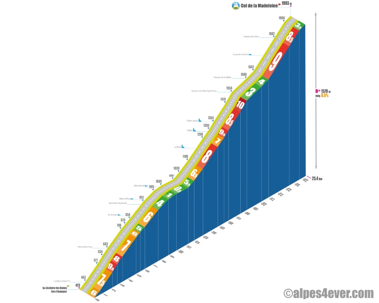
The Col de la Madeleine - 1993 m - links the Tarentaise and Maurienne Valleys. With its "almost" 2,000 m height, significant vertical drop - over 1,500 m - and long distance on both sides, it belongs to the family of "out of category" passes.
The North side is the most affordable, and is the most accessible. The North side is the most affordable, even with a higher gradient - 1617 m at 6.5% - but you shouldn't underestimate its length, at almost 26 km. The ascent, more bucolic on this side, is more irregular and is divided into 3 parts:
. Starting from Feissons-sur-Isère in the Tarentaise Valley, you'll have to climb 8.3 km to Villard-Saffray (shortly after Bonneval) on an average gradient of 6.5%, including a 600 m section at 9.5%.
After that, the gradient alternates between the two sides of the mountain, with the first section at 9.5%. After that, the gradient alternates between two passages at 5% and a descent for 5.4 km. That's still less effort on this long climb.
A little over 12 km remain from La Thuile, where the gradient takes over again, averaging 7.5%, with a 600 m section at 10% on the outskirts of Celliers-dessus. As you approach the final stretch, a 1.7 km, 4% gradient flat will give you a chance to recharge your batteries, making it easier to get through a final series of 6 hairpin bends, in a magnificent wild setting, with reasonable percentages (6.5% for the last 1400 m) and reach the Col de la Madeleine at 1993 m.
.
Topo south side
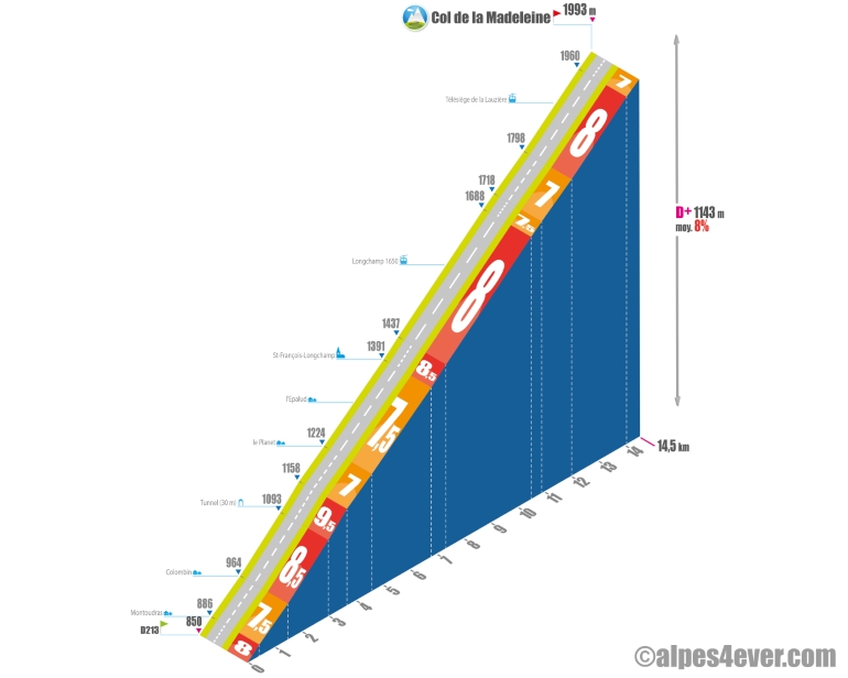
The Col de la Madeleine - 1993 m - links the Maurienne and Tarentaise Valleys. With its "almost" 2,000 m altitude, significant differences in altitude - over 1,500 m - and long distances on both sides, it belongs to the family of "hors catégorie" passes.
Descending the Col du Chaussy, the ascent of the southern slope joins the D213 well above La Chambre - the real starting point in the Maurienne Valley. You'll have eclipsed a small part of the difficulties, but there's still plenty to do, with 14.5 km at an average gradient of 8%, which suggests that it's not going to be easy! When you reach the D213, you'll be hoping for a flat or gentle slope to warm you up... but no, you'll have to start with a big effort for 1.6 km at 8/9% up to the hamlet of Montoudras. After that, the next kilometer at 7.5% (yes, it won't be easy!) gives you a chance to get back into the swing of things. At Colombin (a few chalets), it's back to business as usual: 2.2 km at an average of over 8.5%, with a short paravalanche to cross (no need for lighting) and the second hardest part of the climb at 690 m at 9.5%. You can only hang on to the slope, as the landscape doesn't offer much to sink your teeth into
. The slope "eases off" a little with 925 m at 7% up to the Planet where, as its name suggests, you'll enjoy a real little flat - approx. 700 m at 5.5%.
.
But the rest will be short-lived, as the gradient - 2.2 km - picks up again, never dropping below 7.5% as you pass through Epalud and then reach the first settlements of St-François-Longchamp. You'll soon feel depressed when you see a straight-as-an-i ramp with a hellish gradient. Beware, the road offers little shade and can become a real oven from late morning onwards. Courage or flight, it's 2.8 km at 8% to the Station de Longchamp 1650! Crossing the Station de Longchamp 1650 will distract you a little, but it's hard to relax your legs after 14.5 km of sustained climbing. You're about to attack the final stretch, with 4.9 km to go and another 375 m of D+ at... 7.5%! Yes, you'll have to be brave!
You'll need to climb 880 m at 8% to reach the top of the resort, but you'll finally be rewarded as the landscape unfolds with a sublime view of the Grandes Rousses-Galibier and Belledonne Massifs and the Aiguilles d'Arves. In the center, you can clearly see the Col du Glandon climb.
You're now progressing through alpine meadows, and you'll experience a soothing 1.5 km section at no more than 7%. But after a left-hand switchback, the gradient picks up again - 1.2 km at 8% - progress is slower, the last switchback seems miles away, the wind is getting in the way and legs are aching. You finally reach the lace symbolized by the Lauzière chairlift. The last 1,300 meters at 7.5% are interminable, but it's got to come to an end: you'll finally reach the Col de la Madeleine. You'll be back in the saddle again, with a superb view of Mont Blanc in front of you!
. The sign at the pass says 2000 m. In principle, this figure is wrong. IGN and the CCC's Chauvot guidebook give the figure as 1993 m. That's a difference of 7 metres! It seems that the Savoie department was a little proud when it produced the sign! Isère was less so for the Col de Sarenne, which - to within a metre - remained at 1999 m!

Author
Joris Lesueur
webmaster of alpes4ever.com
contact@alpes4ever.com