
Bisanne climb
Summary
- Plan your bike ascent of the Montée de Bisanne
- Bisanne ascent by bike from Ugine
- Description of ascent from Ugine
- Ascent of Bisanne from Villard-sur-Doron
- Description from Villard-sur-Doron
- Advice to prepare for the climb
- Weather conditions
- Recommended equipment
- Services next to Montée de Bisanne
- Access to Montée de Bisanne
- Témoignages
- FAQ
- The other nearby passes
- The most beautiful passes
- Places to visit nearby
Plan your bike ascent of the Montée de Bisanne
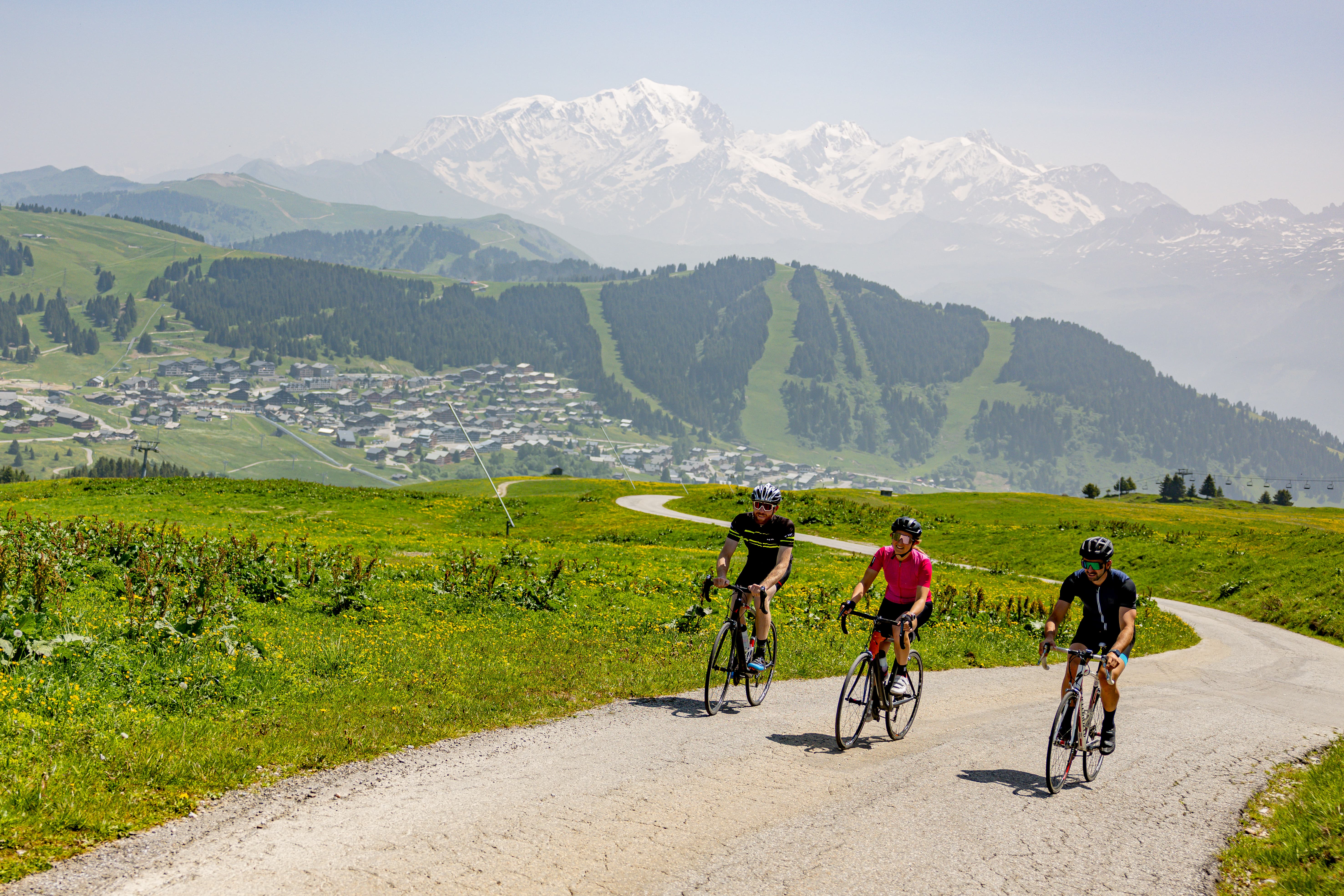
The Montée de Bisanne leads to the small resort of Bisanne 1500, then to Signal de Bisanne, in the heart of the Beaufortain, in an open environment between forest and alpine pastures. Between Villard-sur-Doron and Les Saisies, this ascent constitutes a demanding variant between the col des Saisies and the Cormet de Roselend, adding a significant difficulty to the Route des Grandes Alpes itinerary.
At the summit, the panorama opens up wide over the Mont-Blanc massif and the Beaufortain relief. Classified as a non-category climb, the Bisanne ascent is characterized by a continuous ascent, the difficulty of which lies as much in its regularity as in the absence of any real recovery phases.
We have selected two main routes: from the north, from Ugine, and from the south, from Villard-sur-Doron.
Bisanne climb by bike from Ugine (north-west side)
- Start : Ugine (426 m)
- Distance: 20.2 km
- Elevation: 1519 m
- Average gradient: 8%
- Maximum gradient: 11.5%
Time to climb (rounded) the Montée de Bisanne by bike from Ugine (northwest side)
- At 7 km/h: 2h 55'
- At 11 km/h: 1h 50'
- At 15 km/h : 1h 20'
- At 19 km/h : 1h 05'
Map of the Montée de Bisanne cycling route from Ugine (north-west side)
Description of the Montée de Bisanne by bike from Ugine (north-west side)
The climb begins in the Arly gorges, with a relatively gradual first section. The profile alternates between moderate uphill sections, flats and even a short downhill section of around. These variations allow for occasional recovery, but lengthen the total duration of the effort.
The climb then develops on the northern flank of Signal de Bisanne, with an overall steady and sustained slope. The effort builds up over time, with a gradual accumulation of elevation gain that can weigh on the approach to the second half.
At the finish towards Bisanne 1500, the difficulty increases markedly. The last few kilometers, shared with the route from Villard-sur-Doron, feature sustained gradients of between 9 and 11.5%, with no real recovery phase.
The ascent ends at Signal de Bisanne, where the panorama opens out onto the Mont-Blanc massif and the Beaufortain reliefs. Despite a less steep profile at the start of the route, this slope remains demanding due to its length and cumulative vertical drop.
Montée de Bisanne from Villard-sur-Doron (south side)
- Start : Villard-sur-Doron (705 m)
- Distance: 14.4 km
- Elevation: 1229 m
- Average gradient: 8.5%
- Maximum slope: 11.5%
Ascent time (rounded) for the Montée de Bisanne from Villard-sur-Doron (south side)
- At 7 km/h : 2h
- At 11 km/h : 1h 20'
- At 15 km/h: 1h
- At 19 km/h: 45'
Map of the Montée de Bisanne route from Villard-sur-Doron (south side)
Description of the ascent of Montée de Bisanne from Villard-sur-Doron (south side)
The first six kilometers, starting from Villard-sur-Doron, alternate between sustained sections and more rolling passages, with already one kilometer around 9%. The road is wide and the surface is of good quality, and the climb takes place mainly in forest, via a series of regular switchbacks. From the sixth kilometer onwards, the profile changes markedly. The gradient steepens from 9 to 11%, with no real recovery phase. The effort becomes continuous and fatigue gradually sets in.
The finish at Bisanne 1500 is a landmark, without marking a break in the difficulty. The next 4.5 kilometers, shared with the route from Ugine, are very tough, with gradients of between 9 and 11.5%. The landscape gradually opens up, as you leave the forest, pass through alpine meadows, then enjoy unobstructed views of the Beaufortain and Mont-Blanc massif.
The last two kilometers are the most testing, due to the combination of steep slope and already accumulated effort. The summit, visible in the final section, seems close, but the approach may seem long.
Direct variant
A more direct variant allows you to reach Signal de Bisanne by cutting the main road (D123) twice.
From Villard-sur-Doron (705 m), the route first follows the classic route, before branching off a first time between the 2ᵉ and 3ᵉ kilometer (approx. 870 m), in the direction of Cray Bas / Cray Haut. A second fork occurs shortly after the 7ᵉ kilometer mark (around 1,330 m), in a switchback, to join a small road passing close to the Chalet de la Lanche.
This option reduces the distance (around 13.7 km), but significantly increases the difficulty, with an average gradient close to 9%. The road here is narrower, more technical, but virtually devoid of traffic.
Tips to prepare for the Montée de Bisanne ascent
Warning, this is serious stuff! And if you're planning to link Saisies - Bisanne - Cormet de Roselend, this is serious stuff: just over 3,500 m of ascent. In other words, you'll need to sharpen up beforehand. This also applies to your equipment.
Our advice:
- You'll be approaching 2000 meters, so you may be very hot or very cold. Take the necessary clothing.
- On the Villard-sur-Doron side, little recovery is possible. Don't go too fast and manage well!
- Ugine side, very long descent, rather steep. On the Villard-sur-Doron side, a shorter but very steep descent. Be careful and don't hesitate to stop!
Weather conditions
The altitude, is not that of the high mountains and there are resorts and villages to shelter you. But that's no reason not to ask around!
Recommended equipment
Pack a windbreaker and warm clothes: they'll come in handy on the way down, and sometimes right on the way up.
The climb requires stamina, especially in changeable weather. Remember to stay hydrated and eat regularly.
A well-tuned bike makes all the difference on this type of prolonged effort: an adapted position helps avoid unnecessary pain.
On a VAE, it's imperative to check the autonomy before setting off: the climb is long and demanding.
Routes via the Montée de Bisanne
Le Grand-Bornand → Beaufort-sur-Doron
Services next to Montée de Bisanne?
Stations of the Saisies and Bisanne 1500, villages in the Beaufortain (Beaufort and Arêches-sur-Doron): there's no shortage of options for refuelling, eating, relaxing and sleeping. You'll be spoilt for choice!
Access to Montée de Bisanne
Rail access:
- Albertville SNCF station
- Bourg-Saint-Maurice SNCF station
Road access:
- D123 from Les Saisies and Villard-sur-Doron
Those who have done it speak best of it!
FAQ
What's the Signal de Bisanne called?
At 1941 m, it's the highest point of the linked resorts of Bisanne and Les Saisies. It's accessible by road, and at its summit there's a high-altitude restaurant, an orientation table, and the arrival point of 5 ski lifts.
Is the ascent to Bisanne difficult?
Classified as hors catégorie, it's a tough climb, particularly after Bisanne 1500. The last 4 to 5 kilometers are the most demanding, with high percentages and very little recovery.
What other passes can you link the Montée de Bisanne with?
The Montée de Bisanne fits naturally between the col des Saisies and the Cormet de Roselend, both on the main Route des Grandes Alpes route. It is a variant that clearly increases the difficulty of this sequence.
Can we take a break on the way up?
Yes, especially at Bisanne 1500, where depending on the season there are restaurants and terraces. It's the main break point before the final kilometers.
Why take the Bisanne climb?
Because it combines performance and discovery. The Montée de Bisanne offers both a sporting challenge and an immersion in open, lively and accessible mountain territory, between forests, alpine pastures and panoramic views of Mont-Blanc.