


Climb the "Balcon de Genève", a unique vantage point overlooking Lake Geneva and the Alps
Altitude 1335 m (col des Pitons)
Massif du Jura
Département Haute-Savoie
Summary
- Plan your bike ascent of Mont Salève
- Bike up the Salève from the north side
- Description of the ascent of Mont Salève by bike by the north side
- Ascent of Mont Salève by bike by the south sidesud-ouest
- Description of the ascent of Mont Salève by bike via the south-western slope
- Conseils pour préparer l'ascension du Mont Salève
- Weather conditions for Mont Salève
- Recommended equipment for Mont Salève
- Services at Mont Salève
- Access to Mont Salève
- Témoignages
- FAQ
Plan your bike ascent of Mont Salève
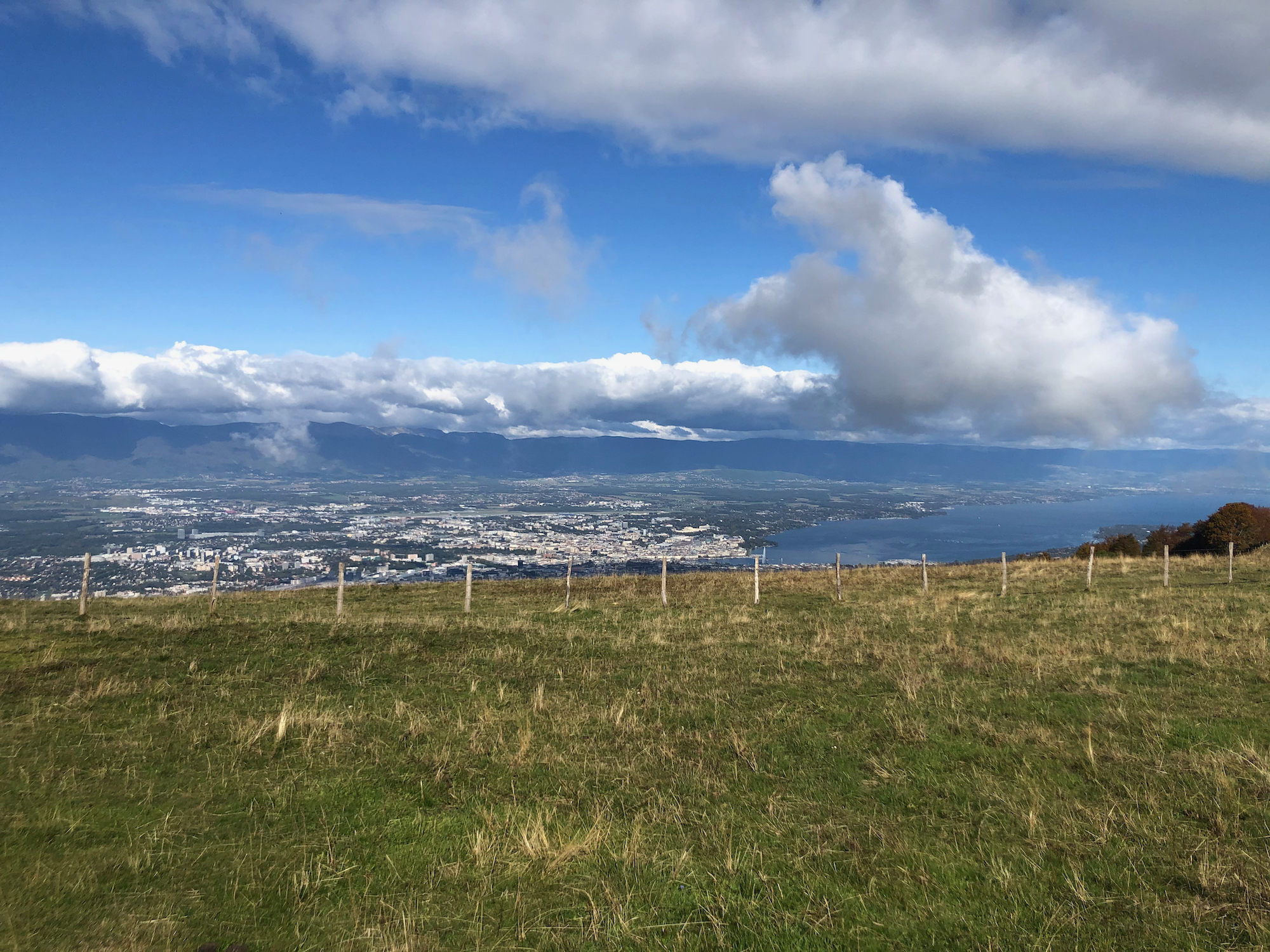
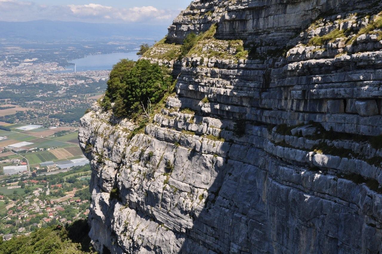
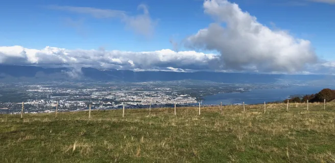
The Salève is, along with Les Voirons and Le Vuache, one of the three massifs that make up the Monts-de-Genève. From the top of its 1,397 m, Mont Salève, often referred to as the "Balcony of Geneva", offers exceptional panoramic views over the city of Geneva, the Jura, Lake Geneva and Haute-Savoie to Mont-Blanc. For cyclists, the highest point is the 1335-metre Col des Pitons. Its ascent, particularly the northern slope, definitely belongs to the collection of great Alpine climbs.
Bicycling up the Salève via the northern slope
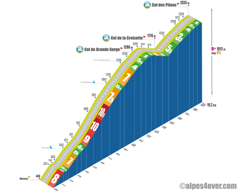
Start : Mornex (448 m)
Distance: 18.7 km
Altitude: 1335 m
Height difference: 1010 m
Average gradient: 6%
Maximum gradient: 10.5%
Cotation Tour de France® : 1ere catégorie
Time to climb (rounded) Mont Salève by bike via the north side
- At 7 km/h: 2 h 40
- At 11 km/h : 1 h 45
- At 15 km/h : 1 h 20
- At 19 km/h : 1 h 00
Map of the Mont Salève ascent by bike via the north side
Description of the ascent of Mont Salève by bike via the north side
The ascent of Mont-Salève via the north side, or to be more precise, the ascent to the Col des Pitons (1335 m), the highest point on the route, is a serious affair. But, if you're coming from Thonon-les-Bains, you're already well warmed up by the Col de Terramont (1098 m) and especially the Col du Feu (1120 m). So you're ready for the Salève challenge!
We're talking about 19.2 kilometers for 1012 meters of ascent, at 6% average, with three kilometers crescendoing from 9 to 10.5%.
It all starts in Mornex, just 450 meters above sea level, with a good kilometer at 8%! You're off for a 12 km section, which will take you up to the Col de Grande Gorge (1286 m). This is the main course of the stage, and in the middle, shortly after Monnetier, there's the aforementioned three-kilometer stretch at an average gradient of 10%. At the end of this particularly difficult section, you're on a 7% gradient for three kilometers, with the Salève cable car station as an intermediate landmark. A much quieter finish at the Col de Grande Gorge with a final kilometer and a half at an average of 5%.
The rest is a piece of cake, or almost! First a false flat, then a descent: three kilometers to the Col de la Croisette (1176 m). And finally, 4.3 km at 4% average to the Col des Pitons.
You can then put the bike down and, shoes permitting, reach the true summit of the Salève at 1379 metres to enjoy, from the Tour des Pitons, an exceptional panorama of Geneva, the Jura, Lake Geneva...
Cycling up the Salève via the south-western slope
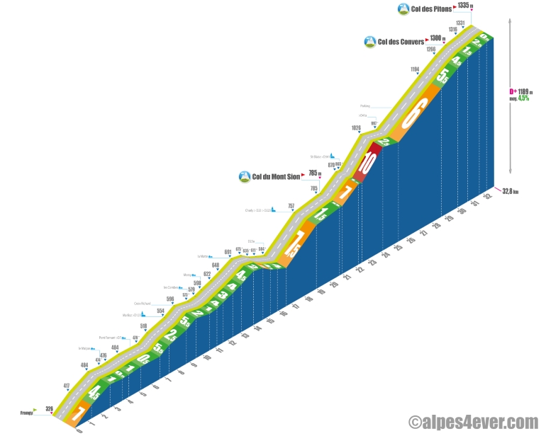 Start: Frangy (326 m)
Distance: 32.8 km
Altitude: 1335 m
Height gain: 1189 m
Average gradient: 4.5%
Maximum gradient: 10%
Tour de France® rating: 1ere catégorie
Temp to climb Mont Salève by bike via the south-west side
- At 7 km/h: 4 h 40
- At 11 km/h: 2 h 40
- At 15 km/h : 2 h 15
- At 19 km/h : 1 h 45
Map of the Mont Salève ascent by bike via the south-west side
Description of the ascent of Mont Salève by bike via the south-west side
A long ascent, fairly irregular, often easy, with the exception of the middle section, before and after the Col du Mont-Sion, which separates the Haute-Savoyard foreland from the French Geneva region. Santa Claus has his "Hameau" here, and he's going to give you a great present: 1650 meters of ascent at 10%, after the village of Saint-Blaise.
But let's get back to Frangy, the starting point of this climb of almost 33 kilometers for 1189 m of positive ascent, at an average of 4.5%. After a start at 7%, the first 17 kilometers are really quiet, even ending with a descent.
Then begins the most difficult part: 7 kilometers, with the famous 10% passage after Saint-Blaise, preceded by a few at 7 and 7.5%, but also a recovery sequence at 1.5%.
After an easy kilometer, you then join the D41A, on which you will complete your climb without inordinate effort. The seven-and-a-half kilometers to the Col des Pitons (1335 m), the highest point on the Salève route, average 4.5%.
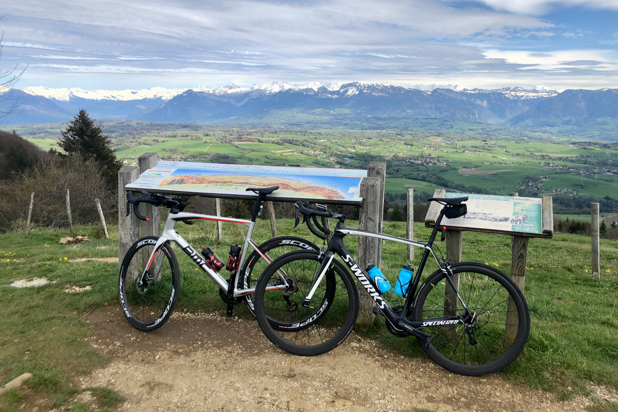
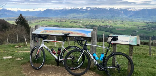
Mandatory photo stop at the orientation table before the Col des Convers (1300 m), inserted before the Col des Pitons. Enjoy the incredible view of the surrounding alpine pastures, the city of Geneva, Lake Geneva, the northern Alps all the way to Mont-Blanc. 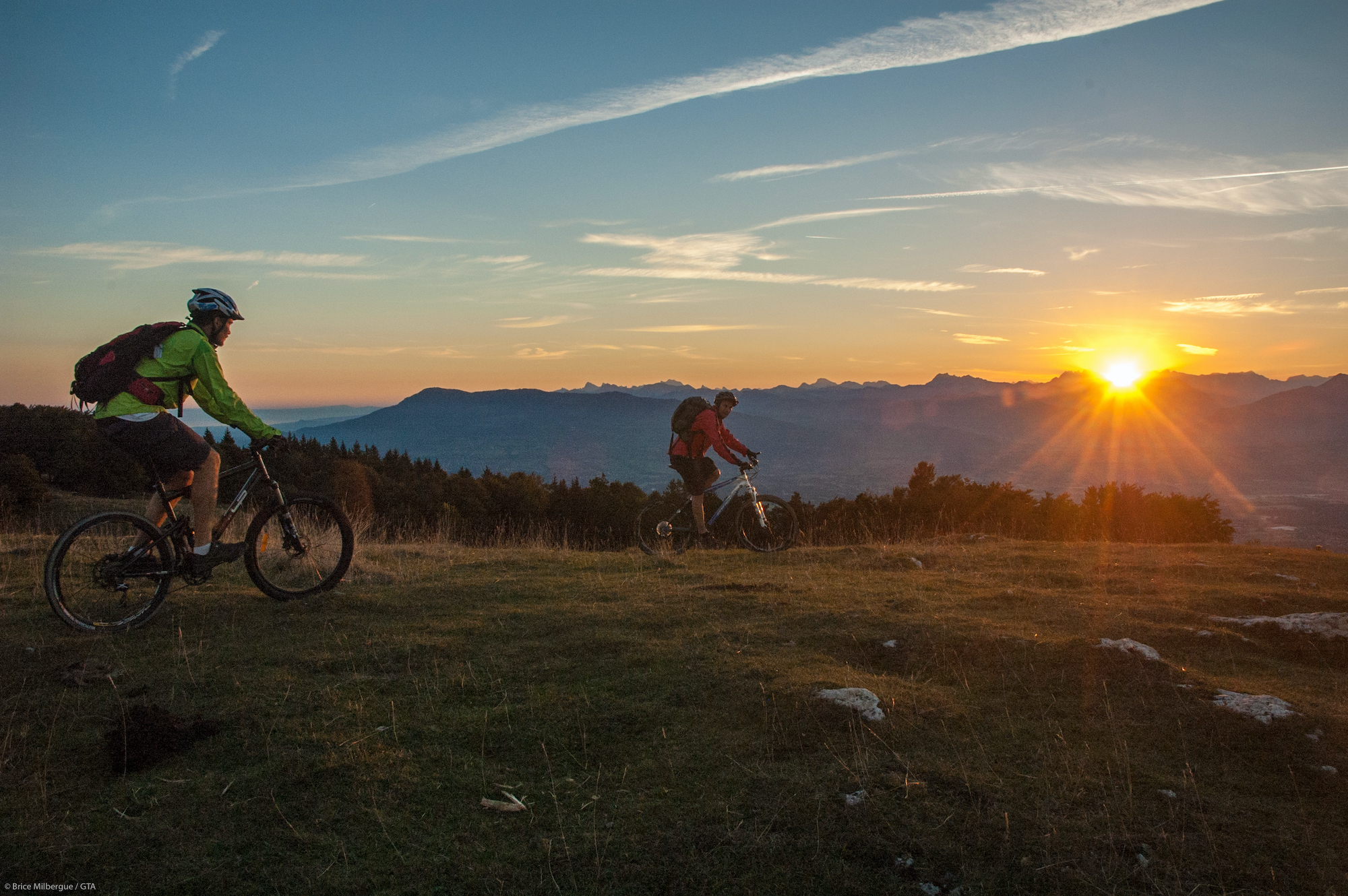
Conseils pour préparer l'ascension du Mont Salève
Its altitude is modest but enough to make you suffer, especially on the north side from Mornex and the Arve valley. So set off well-trained, especially if you're planning several successive stages on the P'tites Routes du Soleil®.
Our advice:
- Have you tried the home-trainer with, for example, the training programs offered by Zwift? Ideal for winter, when you can't put a wheel outside!
- You can't improvise roaming by bike. 12 questions and 12 key answers to make your cycling trip a success on Route des Grandes Alpes or P'tites Routes du Soleil.
- You're looking for a specialist travel agency to cross the Pre-Alps from north to south. Check out our partners La Rébenne and Vélorizons
Weather conditions for Mont Salève
The road between La Croisette and the Col des Pitons, the highest point of the Mont Salève route, can be used as a cross-country ski trail in winter... when conditions permit. In fact, the Salève is accessible all year round from 3 of its 4 slopes (Monex, Archamps and La Muraz). Beware of the fog and cold that can suddenly descend on the summit!
For weather conditions at the Col des Pitons and on Mont Salève, you can consult one of these sites:
Search.ch or Meteoblue
Recommended equipment for Mont Salève
The Mont-Salève (1379 m) and the Col des Pitons (1335 m) are very representative of the difficulties encountered on the P'tites Routes du Soleil. It's not very high, but it can sometimes hurt! So, respect and impeccable equipment if you want to have fun.
Power bike? Check out this section
Electric-assist bike? This article is for you
Services at Mont Salève
There are no cafés or restaurants at the top of the Col des Pitons. However, on the northern slope, the arrival station of the Salève cable car (109 m) offers a restaurant and a variety of activities, including a museum telling the story of the site (scheduled to open in spring 2024). Also several café-restaurants between the summit and the Croisette for a panoramic break!
Near urbanized areas and dotted with villages, the two slopes - north and west - offer multiple refreshment opportunities,.
Access to Mont Salève
SNCF and bus stations
- Annemasse
- Bellegarde-sur-Valserine
- Frangy
- Geneva
- Saint-Julien-en-Genevois
- Thonon-les-Bains
Road access
- D41A from Monnetier-Mornex, in the Arve valley.
- D992 from Frangy, then D7 to Minzier, then D123 to Marlioz, then D23A to Cernex, Then D23 then Route du Mont Sion to Charly, then D223 to Mont Sion, then D341 to Saint-Blaise, D41A to Col des Pitons.
Those who have done it speak best of it!
For those who want to enjoy the view without suffering too much, I recommend the route from Cruseilles. A dozen kilometers and 6% maximum via the Col des Convers, at 1300 meters... Jean-Marc, Allonzier-la-Caille.
I've ridden a lot on the P'tites routes du soleil and swallowed quite a few passes. The northern slope of the Salève is really one of the most formidable. Above all, don't underestimate it! Dominique, Geneva.
I love riding in the mountain pastures on the Salève, not to mention the panorama of course! Chantal, Annecy.
The Salève climbs are one of my training routes. It's long, it's beautiful and, above all, it's very physical! On the south-west side, the straight stretch above Saint-Blaise is an indicator of your fitness! I also have a painful memory of being trapped by snow in April between Croisette and Col des Pitons... I came home in a sorry state! Finally, on the lesser-known side, the climb from Archamps, with a 4km wall averaging over 10% after Le Coin: brutal! Lionel, co-host of Route des Grandes Alpes ®
FAQ
What are the 3 Mounts of Geneva?
The Voirons, the Vuache and of course the Salève are the 3 mounts, or rather the 3 massifs that dominate Geneva and its surroundings.
Has the Tour de France ever passed over the summit of the Salève?
Between 1973 and 1992, the Grande Boucle crossed the Salève four times, generally classified as category 1. It is also on the program for the queen stage of the Critérium du Dauphiné 2024.
When was the Mont Salève cable car inaugurated?
A first cable car, designed for goods, operated from 1913 to 1953. The passenger ropeway, designed by Swiss architect Maurice Braillard, was inaugurated in 1932. It replaced a rack railway. Closed in 1975, it was modernized and reopened in 1984. Both stations will close again between 2021 and 2023. Modernized, they will then host new services and leisure areas.
What types of cycling can be enjoyed on Mont Salève and nearby?
Road, muscle and electric-assist cycling, but not only! A number of mountain bike trails offer tracks for all levels, and riders can use the cable car to transport their bikes. The Monts de Genève territory, to which Mont Salève belongs, has also begun developing Gravel routes.
The map
The map
2 Boëge / La Muraz
3 La Muraz / Desingy
The other passes near Mont SalèveMontée de la Chambotte
| The most beautiful passes on P'tites Route du Soleil ®Col du Feu |
Places to visit near Mont Salève