
Altitude 1370 m
Massif du Vercors
Département Isère
Topo versant Est
The Col d'Herbouilly - 1370 m - is a pass in the northern Vercors Massif. It serves as a transition between the east and west of the massif, and also between Isère and Drôme. At the same time, you can cross the Col de Chalimont.
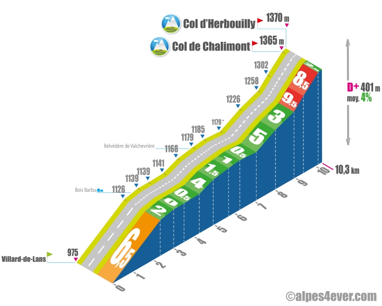
The 10.3 km-long eastern slope starts in Villard-de-Lans. Its ascent takes place in 3 stages:
A beautiful 2.3 km, 6.5% gradient takes you up to Bois Barbu.
Then it's down to business as you pass through the Site Nordique de Bois Barbu to the Belvédère de Valchevrière, with a 4.7 km series of flat stretches and gentle climbs. From the belvedere, take a look at the village, which was destroyed by the Germans in July 1944 during the Second World War. Only the chapel was not burnt down.
On leaving the belvedere, the slope takes over again, with 940 m at 5%, followed by 910 m at 3%. Don't get carried away on this fairly easy section, though, as the final climb is terrible: 470 m at 9.5%, followed by 725 m at 8.5%. You'll then reach the Col... de Chalimont - 1365 m -, an intermediate pass at 185 m with an additional 5 m D+ from the Col d'Herbouilly - 1370 m. The passes are located in the middle of the woods and won't offer you any views.
Topo west side
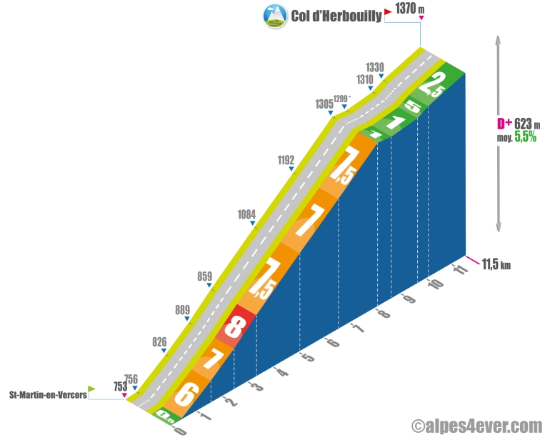
11.6 km long, the West slope starts at St-Martin-en-Vercors in the Drôme. The climb is steeper than on the eastern side. It really starts just outside the village on the D103, which you'll have to follow to a right-hand junction that takes you to the Col d'Herbouilly on the D331. Count on 6.5 km with a gradient of between 6 and 8%. The descent is followed by a gentle ascent to a belvedere offering a beautiful view of the magnificent Prairie d'Herbouilly. The final stretch is pleasant, with 1.4 km at 2.5% to reach the Col d'Herbouilly at 1370 m.
The map
The map
10 Villard-de-Lans / Die
Author
Joris Lesueur
webmaster of alpes4ever.com
contact@alpes4ever.com