


Col du Grand Colombier
Taking on the "4-headed monster"!
Plan your ascent of the Col du Grand Colombier by bike
The Col du Grand Colombier is one of France's most feared passes. The highest road pass in the French Jura, it offers spectacular views over the Rhône valley, Lac du Bourget and the Alps. Its difficulty has given rise to the Confrérie des Fêlés du Grand Colombier, which brings together cyclists who come to take up the challenge of climbing two, three or even all four slopes in the same day. Crossed five times by the Tour de France, the pass owes its reputation to its atypical profile: long, irregular slopes, frequent passages at over 10%, and walls that can exceed 14%, or even more depending on the slope. With its four possible climbs, each with its own character, it is often nicknamed "the four-headed monster".
Close to the route of the P'tites Routes du Soleil®, the Col du Grand Colombier is well worth a visit.

Ascent of the Col du Grand Colombier by bike from Anglefort (north-east side)
- Start : Anglefort (289 m)
- Distance: 15.3 km
- Elevation: 1209 m
- Average gradient: 8%
- Maximum gradient: 13%
Time to climb (rounded) the Col du Grand Colombier by bike from Anglefort (northeast side)
- At 7 km/h : 2h 15
- At 11 km/h : 1h 25
- At 15 km/h : 1h
- At 19 km/h: 50'
Map of the route up the Col du Grand Colombier by bike from Anglefort (north-east side)
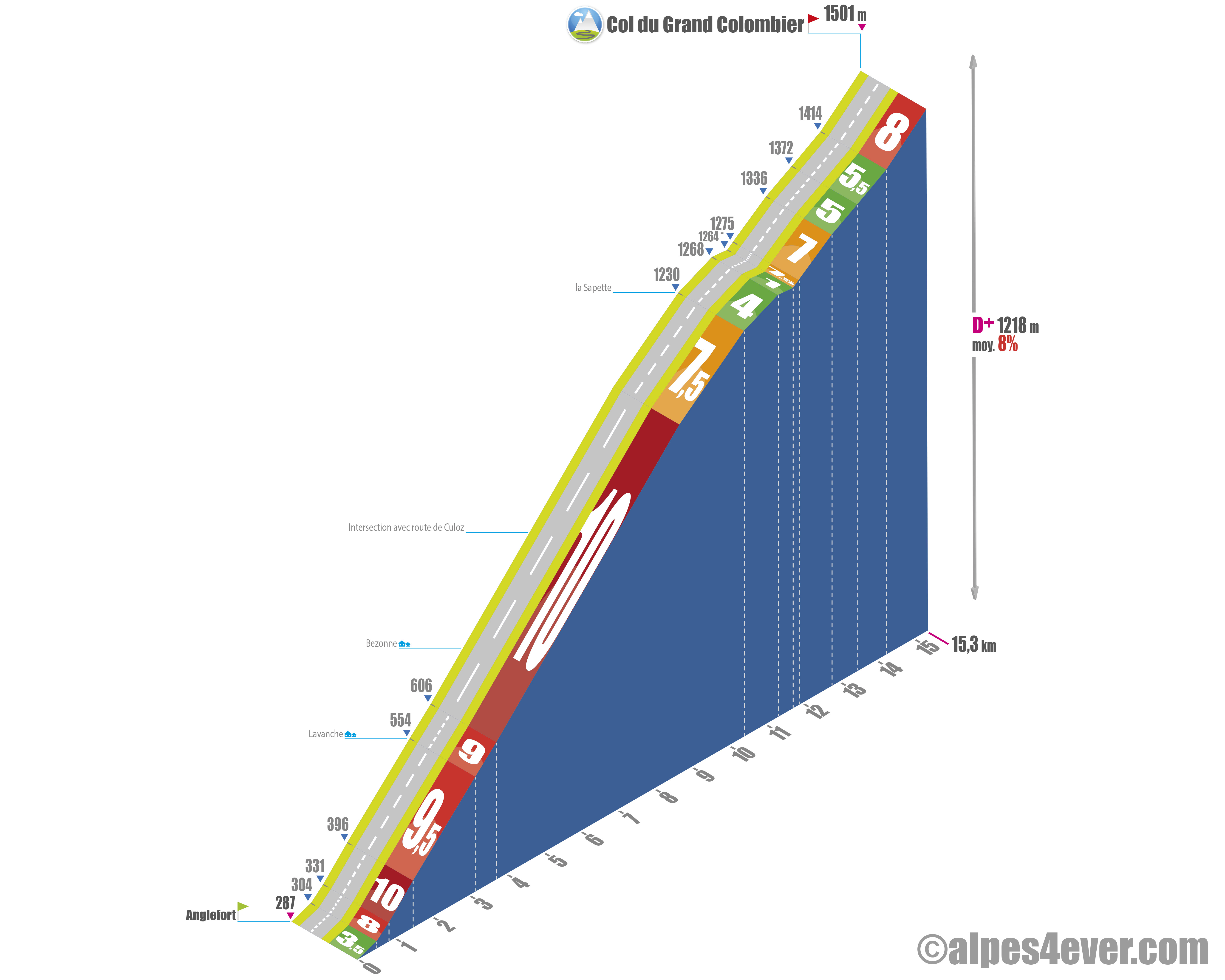
Description of the ascent of the Col du Grand Colombier from Anglefort (north-east side)
From the ninth kilometer, same route as for the route from Culoz. Not a moment's respite, or almost none, until kilometer 9!
Nothing to do but find a rhythm and stick with it. The kilometers go by, but nothing really changes. No real flat spots. No break. Just an insistent slope.
The forest becomes enveloping, the landscape more enclosed. You feel quite alone with your effort. It's a climb of pure endurance, constant and wearing. Fortunately, the last 5.5 km, just before La Sapette, are more forgiving!
Ascent of the Col du Grand Colombier by bike from Champagne-en-Valromey (north-west side)
- Start : Champagne-en-Valromey (531 m)
- Distance: 18.8 km
- Height gain: 967 m
- Average gradient: 5%
- Maximum gradient: 14%
Time to climb (rounded) the Col du Grand Colombier by bike from Champagne-en-Valromey (northwest side)
- At 7 km/h : 2h 40'
- At 11 km/h : 1h 45'
- At 15 km/h : 1h 15'
- At 19 km/h: 1h
Map of the route up the Col du Grand Colombier by bike from Champagne-en-Valromey (north-west side)
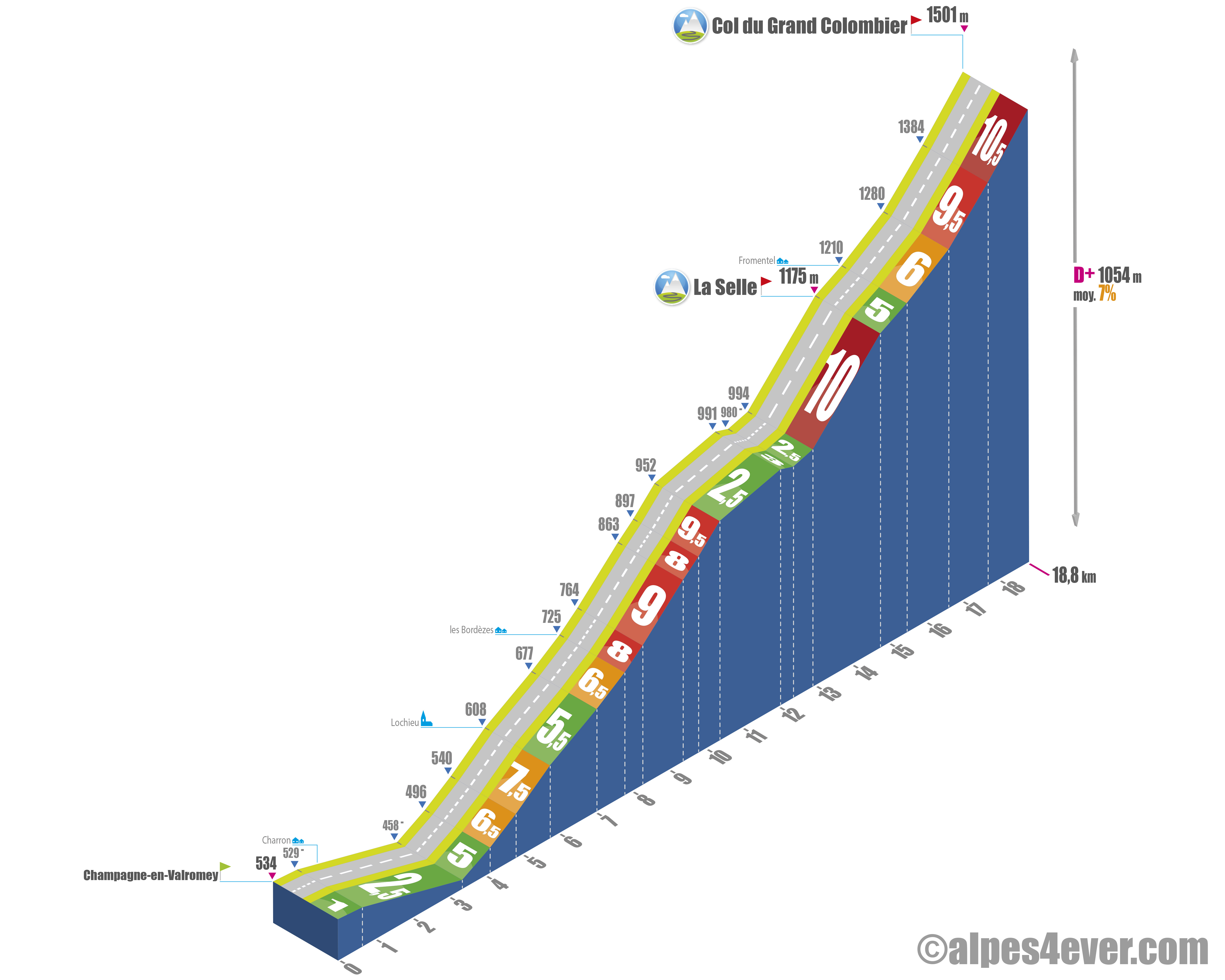
Description of the ascent of the Col du Grand Colombier from Champagne-en-Valromey (north-west side)
Without question, the most accessible ascent. Firstly, because it starts higher up (531 m), there's less climbing to do. Secondly, because there are a number of passages where you can put your feet up again! Be careful, though, as there are some extremely brutal sections. From the 14% for just over a kilometer at the end of the first third of the route, to the final three kilometers, shared with the road coming from Artemare.
The first kilometers are in a strolling logic. The road is wide. The landscape is open. It's uphill, of course, but the road is wide and you can breathe without constraint. The Valromey scenery rolls by at a leisurely pace...
There's a 14% gradient between the seventh (and even slightly earlier) and eighth kilometers, but it soon gives way to six rather quiet kilometers. Enough to refuel, before the final section, where the route joins that of Artemare.
Ascent of the Col du Grand Colombier by bike from Culoz (southeast side)
- Start : Culoz (237 m)
- Distance: 17.7 km
- Height gain: 1261 m
- Average gradient: 7%
- Maximum gradient: 11%
Time to climb (rounded) the Col du Grand Colombier by bike from Culoz (southeast side)
- At 7 km/h : 2h 30'
- At 11 km/h: 1h 35'
- At 15 km/h: 1h 10'
- At 19 km/h: 55'
Map of the route up the Col du Grand Colombier by bike from Culoz (southeast side)
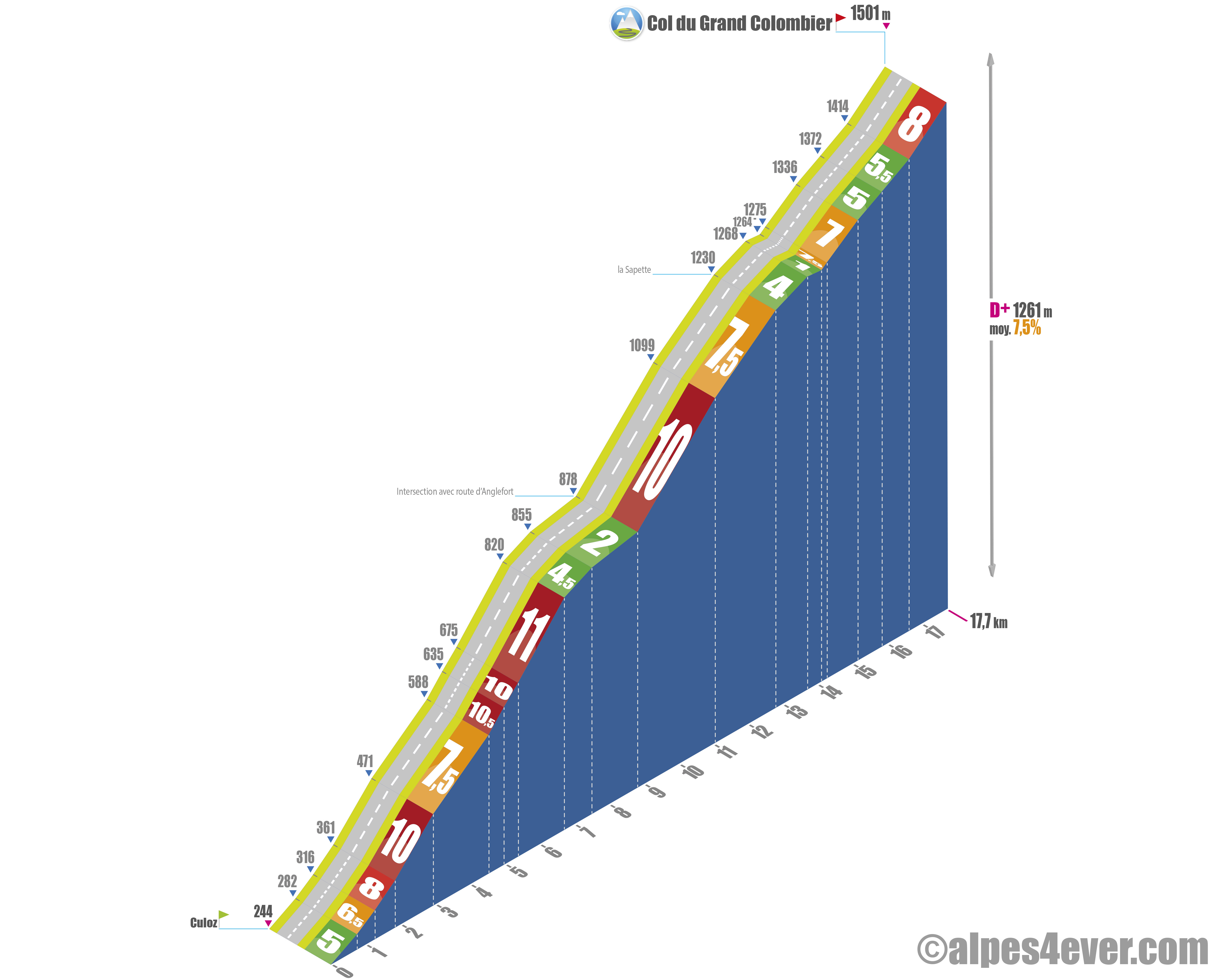
Description of the ascent of the Col du Grand Colombier from Culoz (south-east side)
Routine and demanding! From the ninth kilometer, take the same route as the one from Anglefort.
This is how you can describe the ascent of the Col du Grand Colombier from Culoz, which begins in the Rhône valley, in an environment that is often hot and lacking in shade. The orientation and steepness of the valley mean that temperatures rise rapidly, particularly in summer. This first part is a point of caution: many cyclists lose feathers, even before tackling the most difficult sections.
The first kilometers present a relatively irregular gradient. Progress remains manageable, but without any real continuity: alternating flats and more sustained passages, which make it difficult to establish a steady rhythm. This characteristic is confirmed as you enter the forest zone, where the climb becomes more choppy.
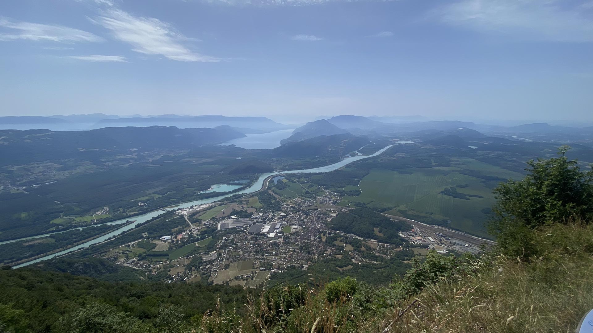
Higher up, the road gradually emerges from the forest and the landscape opens up. The Culoz slope is then distinguished by a series of spectacular switchbacks, clinging to the slope above the valley. Unlike other iconic climbs such as the Alpe d'Huez, these switchbacks are fewer in number and, above all, less legible as a whole. There is no visual effect to anticipate the summit.
This configuration reinforces the sensation of length. The climb gives few landmarks and can seem interminable. "You think it's over... and here it is again!"
On a physical level, the difficulty lies not just in the percentages, but in the irregularity of the effort. The succession of slope changes prevents any lasting stabilization, which accentuates fatigue as the kilometers go by.
The last 5.5 kilometers, a little before the place called La Sapette, are quieter. The arrival at the summit often comes with a sensation of gradual wear and tear rather than brutal effort.
This slope is generally considered the most emblematic of the Grand Colombier: spectacular for its panoramas, but above all demanding for its irregular profile and lack of visual landmarks.
Bike up the Col du Grand Colombier from Artemare (south-west side)
- Start : Artemare (245 m)
- Distance: 15.4 km
- Stop: 1253 m
- Average gradient: 8%
- Maximum gradient: 15%
Time to climb (rounded) the Col du Grand Colombier by bike from Artemare (southwest side)
- At 7 km/h : 2h 10'
- At 11 km/h : 1h 25'
- At 15 km/h : 1h 05'
- At 19 km/h: 50'
Map of the route up the Col du Grand Colombier by bike from Artemare (southwest side)
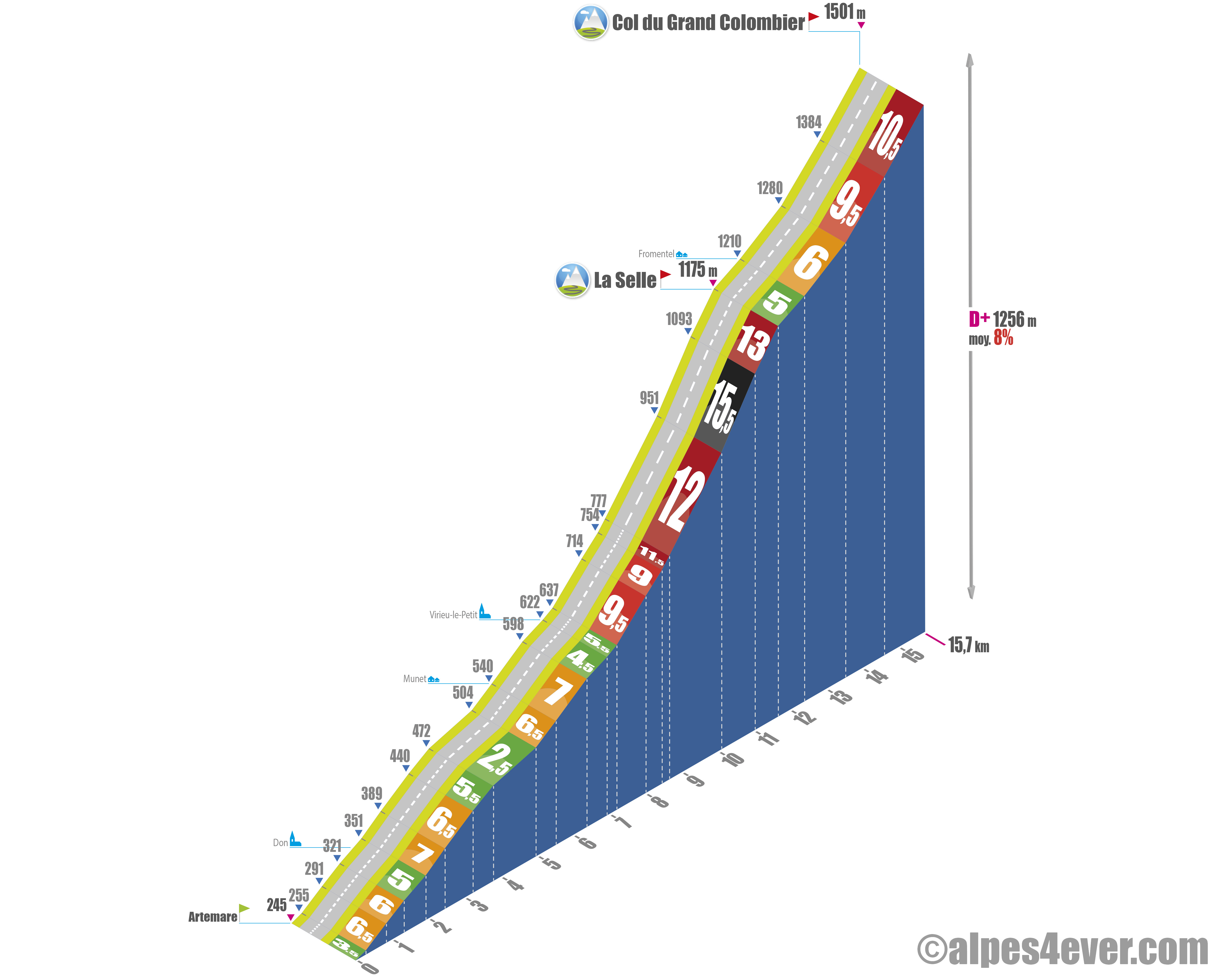
Description of the ascent of the Col du Grand Colombier from Artemare (south-west side)
The Artemare side is generally considered the most difficult. Yet the first seven kilometers, up to Virieu-le-Petit, are rather quiet.
It's in the last 8.5 kilometers, in the second half of the climb, that the Artemare route forges its reputation. From Virieu-le-Petit, in fact, the road straightens out abruptly, stringing together long, steep sections.
First four brutal kilometers, with extreme passages that can exceed 18%. Fortunately, this is followed by a kilometer at the Col de la Selle, at the junction with the Champagne-en-Valromey route.
A welcome respite before the finale: three very sustained kilometers, including a very severe 12.5% section. The summit at 1498 or 1501 meters (according to the sign) is more than welcome!

Advice to prepare for the ascent of the Col du Grand Colombier
The Col du Grand Colombier has nothing to envy of many great Alpine passes. So don't venture there without excellent preparation. Our advice:
Weather conditions
The Col du Grand Colombier is generally open from mid-April to November. Even if it's not in the high mountains, don't embark on the climb without having locked in the weather. Thunderstorms, rain, wind and even snow (in spring and September) are always possible.
Weather at Col du Grand Colombier: www.meteoblue.com/fr/meteo/semaine/le-grand-colombier_france_3015273
Recommended equipment
Provide a suitable gear ratio to handle the uneven slopes well.
Pack two water bottles, enough to eat, a windproof jacket for the descent and a repair kit in case of a glitch.
Services next to the Grand Colombier pass
On the road to the summit, from Anglefort or Culoz, the Auberge du Grand Colombier, a real restaurant.
All services from the 4 slopes.
At the summit, La Pause du Grand Colombier, open in season, is a snack, refreshment point, popular with cyclists.
Access to the Grand Colombier pass
Rail access :
- Culoz SNCF station (TER)
- Bellegarde-sur-Valserine TGV station
Road access:
- Highway: A40 (Bellegarde exit) or A43 (Aix-les-Bains exit)
- D120
Those who have done it say it best!
"You're a cyclist who doesn't shy away from big hills... You like to set yourself personal challenges... You dream of tackling one of France's toughest mountain passes... The terrifying gradients give you wings... 2, 3 or 4 "hors catégorie" passes in a row don't scare you... Riding on almost car-free roads with the Mont Blanc chain as a backdrop is not something you don't enjoy... And all on a day of your choosing... Then you're a potential "Fêlé"! Come and join the 2386 members of the brotherhood!"
"I did the Calvaire de Portes (1007 m) and the Grand Colombier via Champagne-en-Valromey in the same day. I recommend it because it's a very serious yet panoramic way of discovering the different aspects of the Bugey region. "
David, Ambérieu-en-Bugey.
"During my preparation, I studied the profiles. They were monstrous, I could hardly believe they were real, I even redid them to make sure they were right. With a few minor differences, my profiles matched those proposed by the Confrérie des Félés du Grand Colombier, and the call was unequivocal: the 14% and 19% passages were definitely there!"
Joris Lesueur, tireless host of alpes4ever
"What stood out for me was the consistency. No surprises, but no respite either. You're always around 8-9%. You have to accept to climb at your own pace and not get burnt out. A very "clean" climb (Anglefort side) ... but still wearing."
Sophie, 52, Lyon.
"When you get to the top, you just think about your survival... which rests on the packet of Granola left downstairs in your car!"
Lionel, Grandes Itinérances / Route des Grandes Alpes.
FAQ
Which is the most difficult side of the Grand Colombier?
The slope from Artemare (via Virieu-le-Petit) is generally considered the hardest. It's one long section after another at over 10%, with some very steep peaks. This is undoubtedly the most physically and mentally demanding climb.
Which is the best side for a more "leisurely" ascent?
The side from Champagne-en-Valromey is the most accessible. Longer but more gradual, it allows you to discover the pass without immediately facing the steepest slopes.
Why is the Grand Colombier a legend among cyclists?
Because it combines several difficulties: length, irregular slopes, very steep passages. With its four very different sides, it also offers real diversity and a complete challenge, making it a pass in a class of its own, the equal of the greatest Alpine challenges.
What fearsome trilogy is it possible to climb in the part of the Jura where the Grand Colombier is located?
The Golet de la Biche, the Mont du Chat and, of course, the Grand Colombier "himself".