


In the Vallée Verte of the Massif du Chablais
Altitude 1120 m
Massifs du Chablais
Département Haute-Savoie
Topo North side
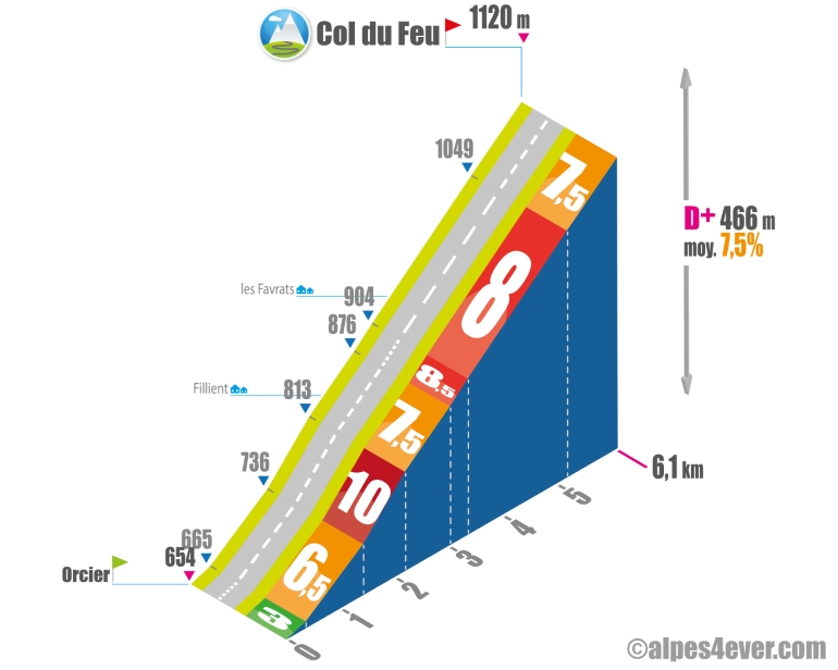
The Col du Feu - 1120 m - is located in the Vallée Verte in the Massif du Chablais. The slope is fairly short from Orcier at 6.1 km. Beware, this will be a fairly strenuous climb at an average of 7.5%, but in a pleasant setting with Lac Léman in the background. At the top of the Col du Feu, there's a fine view of several peaks in the Massif du Chablais, including Mont Billiat (alt. 1894 m).
South side top
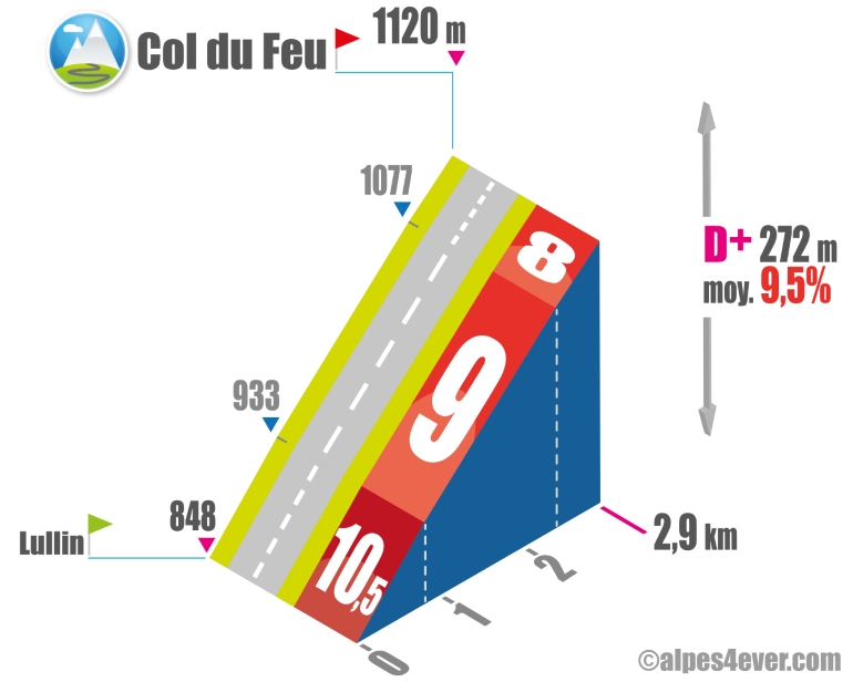
Short and very intense with its 9.5% average gradient, the South slope will present you with a nice challenge... but it should be met with flying colors after a journey of 865 km and 17750 m of positive elevation gain!!!!
The map
The map
1 Thonon-les-Bains / Boëge
In Haute-Savoie, between Lake Geneva and the Vallée Verte area, cycle along following the Franco-Swiss border, perched high above one of the most beautiful lakes in the world. Your journey begins at lakeside Thonon-les-Bains, official starting point of France’s grandes traversées alpines (or great Alpine crossings), to be tackled on foot, by road bike or on a mountain bike. Here, your way is shared with the second stage of the ViaRhôna cycle route linking Lake Geneva to the Mediterranean via the Rhône Valley. On the P’tites Routes du Soleil®, you’re heading out to tackle the cycle route through the French pre-alpine ranges. After a fairly short but very demanding climb, you cross the Col du Feu (1,120m in altitude), the first pass in a long line. Then descend into the Vallée Verte, to the banks of the usually peaceful Menoge River. Soon you come to the Col de Terramont (at 1,098m), which is less testing and takes you to Boëge.
Author
Joris Lesueur
webmaster of alpes4ever.com
contact@alpes4ever.com