


A long-awaited summit
Altitude 2108 m
Massifs du Parpaillon et des Escreins
DepartementHautes-Alpes
Topo North side
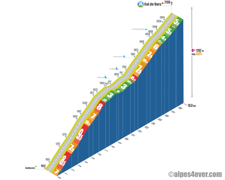
With a length of almost 19 km, the Col de Vars is climbed in 4 parts: the first - the hardest - with 7.3 km on a steep slope at 8% average, the second with 4.3 km, beneficial, to rally St-Marcellin then Ste-Marie, the third where business picks up again passing through the Station de Vars with 4 km at 7% average, the fourth with 4.2 km, easy on paper, but the legs can be heavy and the Col de Vars, long to be desired!
South side top
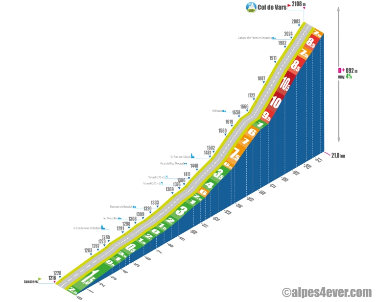
The Col de Vars can be climbed in 2 stages. From Jausiers, the first 13.6 kilometers are fairly easy, the last 9 are formidable despite the low positive gradient - 892 m - for the ascent of this "2000" which would lead one to think that things would be easy.
On leaving Jausiers, the Vallée de l'Ubaye suddenly tightens up, the Ubaye becomes tumultuous but the gradient will be insignificant - no more than 2% average. After La Condamine-Châtelard, you can admire the impressive Fort de Tournoux clinging to the cliff 300 m above. Turn left towards Les Gleizolles. There's almost 15 km of climbing left, but the gradient is still fairly gentle.
The Pas de la Reyssole pass with its tunnel will take you "into the mountains"! As you exit the tunnel, you'll discover another valley - a magnificent one, with the village of St-Paul-sur-Ubaye (alt. 1486 m) as a backdrop.
The real ascent of the Col de Vars begins in St-Paul-sur-Ubaye, and the tone is about to change, as you'll have to reckon with 8.1 km at almost 8% average. You start off about 2.5 km up a fairly irregular slope - 6.5 / 7.5 / 7 / and 6.5%. Beware: a good little headwind can get in the way! But take time to admire the beautiful Barre de la Pisse! Just before the hamlet of Mélezen (alt. 1666 m), there's a welcome 725 m flat spot to relax your legs before the last part of the climb, which will be the... hors d'oeuvre!
Just after the last house, the break in gradient is dry: 9.5% to increase again to 10% then 10.5% as you pass the first 2 laces of a series of 5 laces... to sum up, you'll finish the last 4.9 km of the climb on an average gradient of 9% to reach the Col de Vars at 2108 m above sea level!
The map
The map
20 Guillestre / Barcelonnette
Author
Joris Lesueur
webmaster of alpes4ever.com
contact@alpes4ever.com