Brice Milebergue

Terramont Pass

An easily accessible "1000 m

Altitude 1098 m

Massifs du Chablais

Département Haute-Savoie

Topo North side

image-20220303151547-1

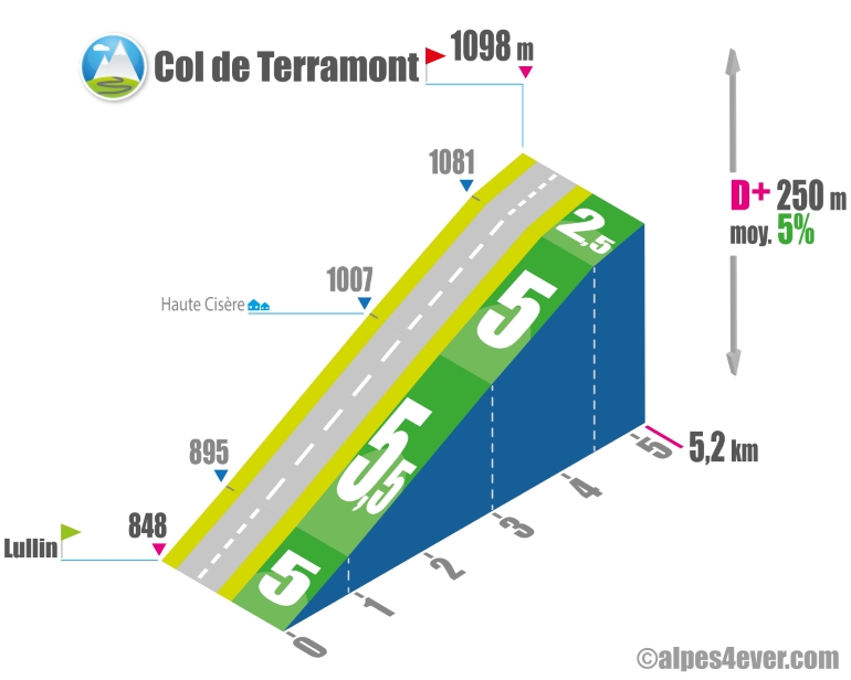
The Col de Terramont - 1098 m - is located in the Vallée Verte in the Massif du Chablais. It is a "1000 m" easily accessible from Lullin to the north.
Starting from Lullin, it's fairly short at 5.2 km and very regular with its 5/5.5%, the last 750 meters at 2.5% will allow you to finish the climb calmly.

Topo South side

image-20220303151559-2

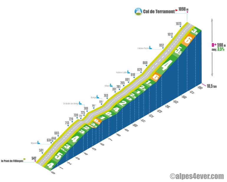
The ascent starts at Pont de Fillinges. At 18.1 km long, it presents no difficulty apart from a long 2.1 km section at 5.5/6% in the final stretch from Habère-Lullin. The only drawback is that it won't be entirely pleasant, as the traffic is quite heavy, but the road is wide enough for a minimum of safety. What's more, the detour via St-André-de-Boëge will give you a bit of peace and quiet.

.

The map

The map

Thonon-les-Bains / Boëge

1 Thonon-les-Bains / Boëge

37 km
3 h 00 min
Medium
In Haute-Savoie, between Lake Geneva and the Vallée Verte area, cycle along following the Franco-Swiss border, perched high above one of the most beautiful lakes in the world. Your journey begins at lakeside Thonon-les-Bains, official starting point of France’s grandes traversées alpines (or great Alpine crossings), to be tackled on foot, by road bike or on a mountain bike. Here, your way is shared with the second stage of the ViaRhôna cycle route linking Lake Geneva to the Mediterranean via the Rhône Valley. On the P’tites Routes du Soleil®, you’re heading out to tackle the cycle route through the French pre-alpine ranges. After a fairly short but very demanding climb, you cross the Col du Feu (1,120m in altitude), the first pass in a long line. Then descend into the Vallée Verte, to the banks of the usually peaceful Menoge River. Soon you come to the Col de Terramont (at 1,098m), which is less testing and takes you to Boëge.

Author

Joris Lesueur

webmaster of alpes4ever.com

contact@alpes4ever.com