
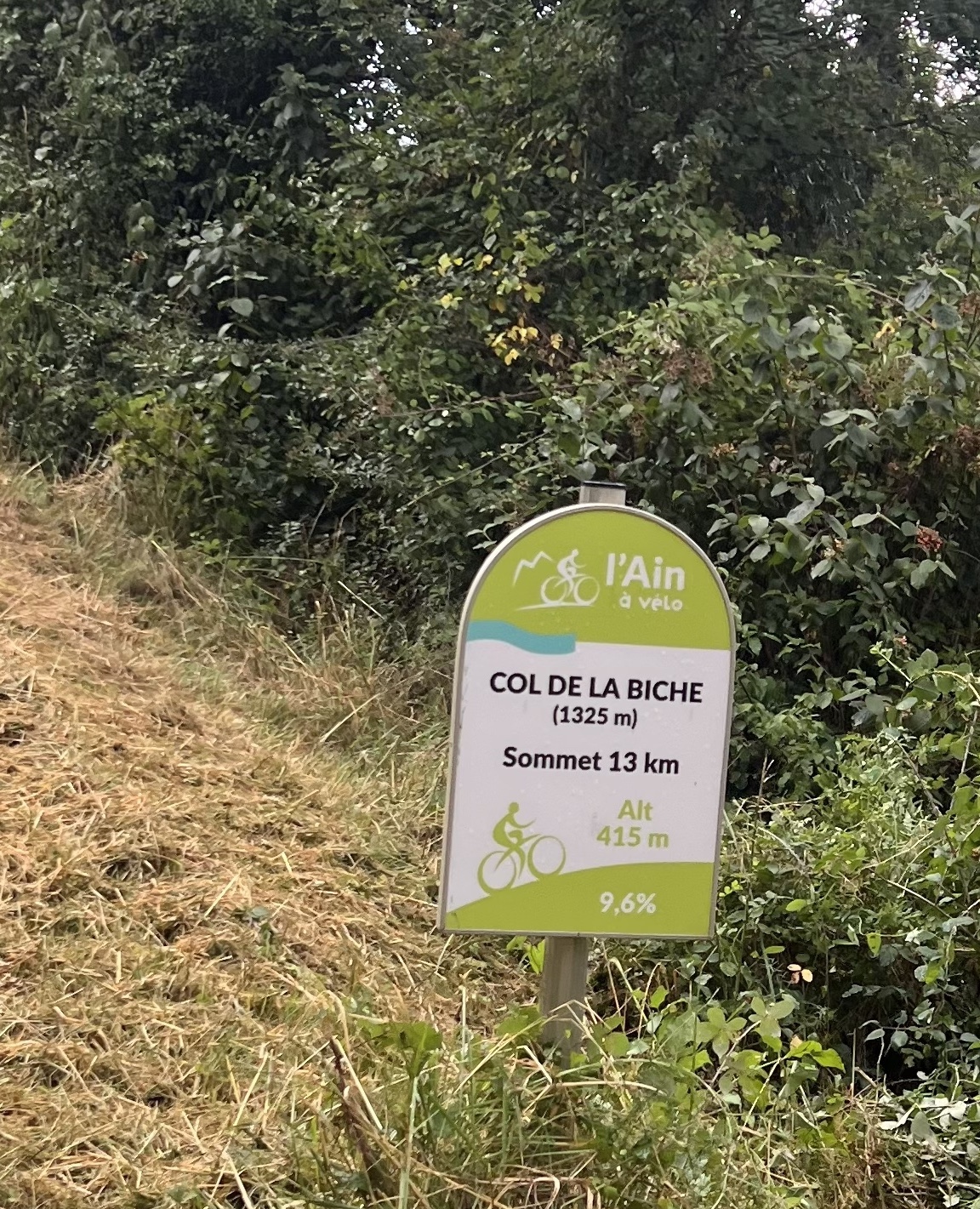
- Altitude: 1325 m (1320 m on the pass sign)
- Massif: Jura (Bugey)
- Department: Ain (Auvergne-Rhône-Alpes)
- Cotation Tour de France: HC
Summary
- Plan your bike ascent of Col de la Biche
- Plan your bike ascent of Col de la Biche
- Bike up Col de la Biche from Gignez
- Bicycling up Col de la Biche from Artemare
- Tips to prepare for the climb
- Weather conditions
- Recommended equipment
- Services at Col de la Biche
- Access to Col de la Biche
- Témoignages
- FAQ
- Les autres cols proches
- Les plus beaux cols de Route des Grandes Alpes ®
- Places to visit nearby
Plan your bike ascent of the Col de la Biche pass
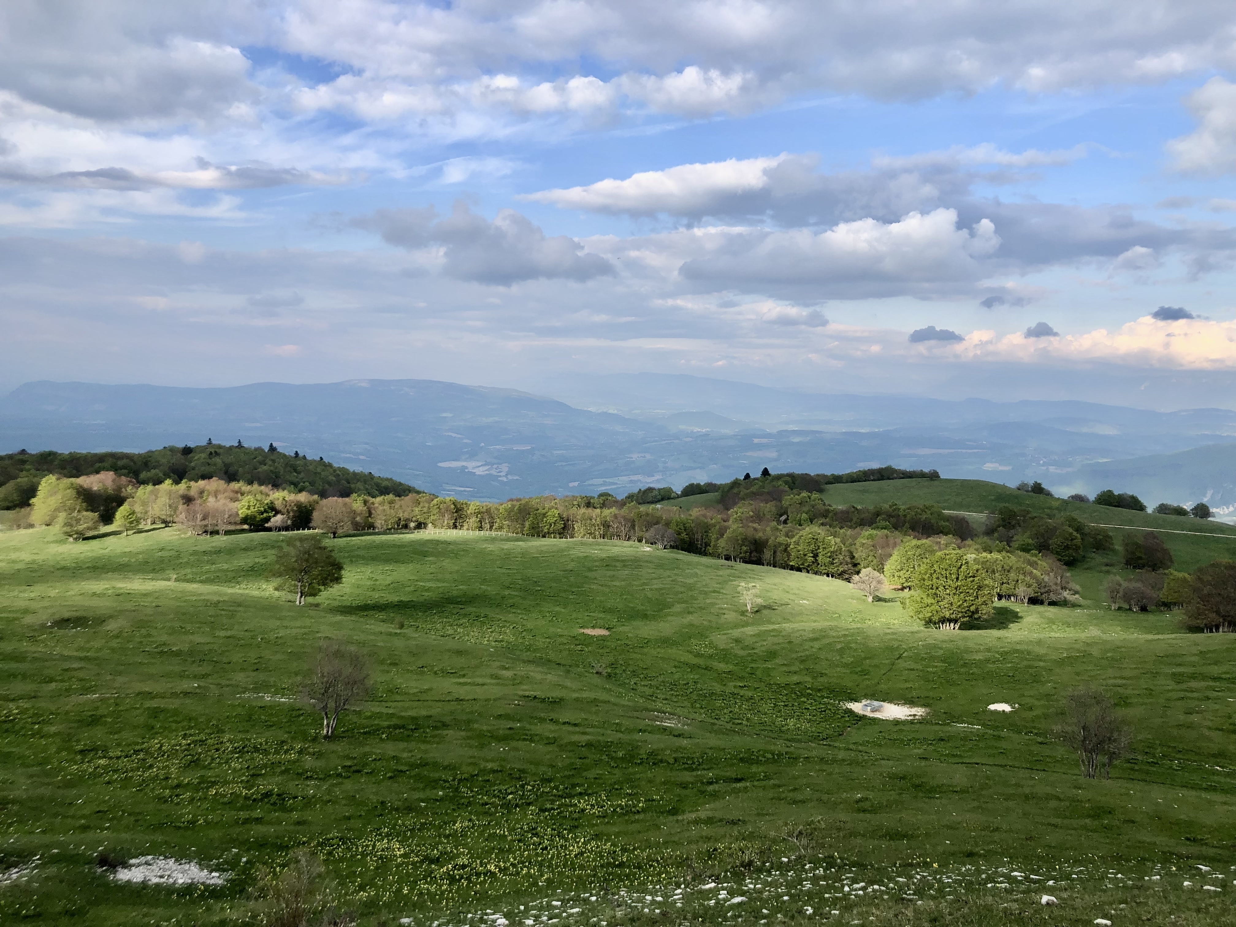
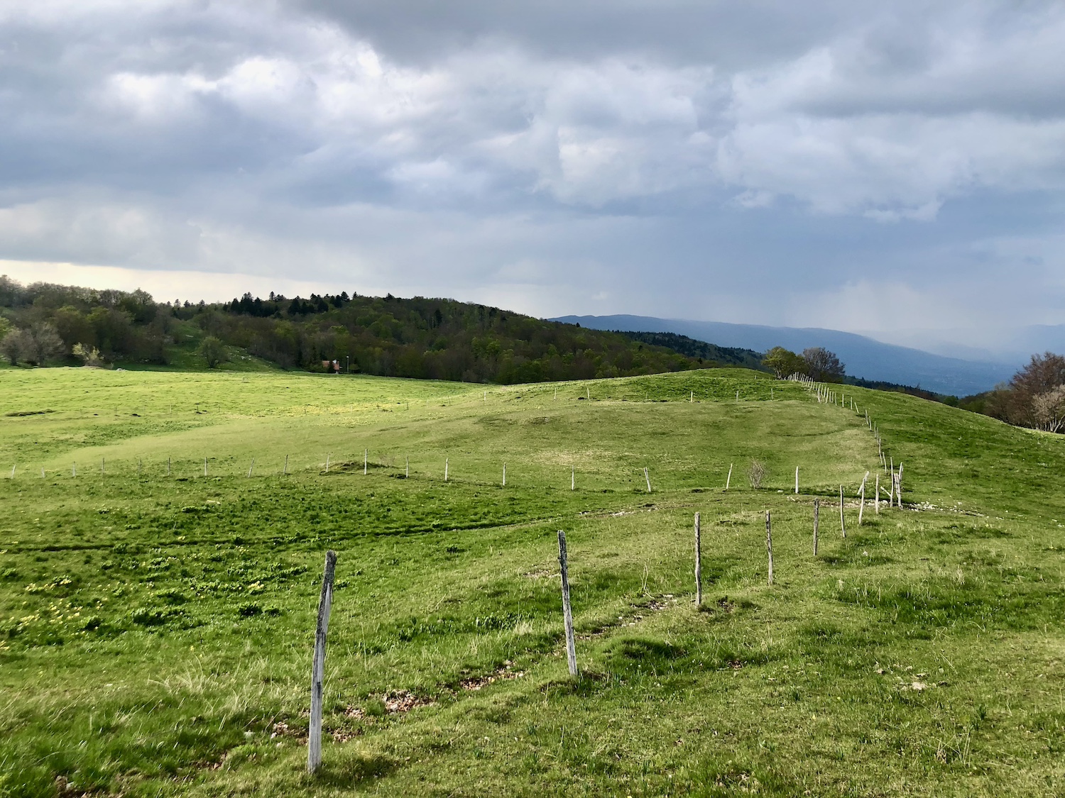
The Golet de la Biche, is a discreet pass in the Bugey region, located near the col du Grand Colombier. Culminating at 1,320 meters (according to the sign), it links Gignez to Artemare in the Valromey heights. Less well known and frequented than its terrible neighbor, it is no less demanding. The climb from Gignez offers a sustained profile, with over 13 kilometers of effort, regular passages at over 10% and a narrow road, often in forest. The Col de la Biche has a seductive character: little traffic, total immersion in nature and a marked sense of isolation. The panorama at the summit is more intimate, opening out onto the Bugey crests and, on a clear day, the Alps. Located in the immediate vicinity of the P'tites Routes du Soleil® itineraries, it offers an authentic detour for cyclists in search of more confidential routes.
Cycling up the Col de la Biche from Gignez (east side)
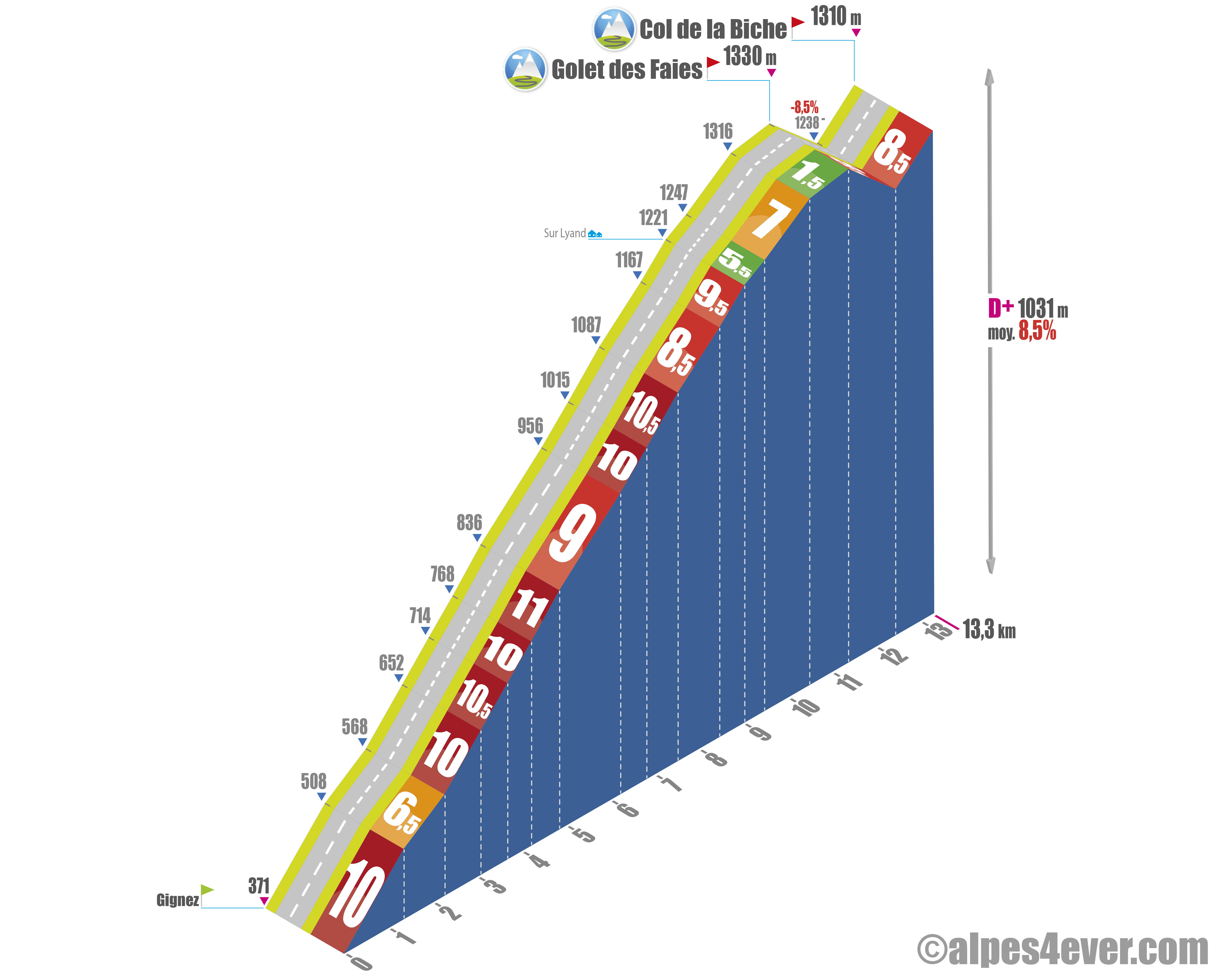
| Start | Gignez (367 m) | Distance | 14 km | Elevation | 958 m | Gradient average | 7% |
| Maximum gradient | 14% |
Time to climb (rounded) Col de la Biche by bike from Gignez (east side)
- At 7 km/h : 2h
- At 11 km/h : 1h 30
- At 15 km/h : 1h 55'
- At 19 km/h: 45'
Map of the route up Col de la Biche by bike from Gignez (east side)
Map to be integrated via Drupal / Openrunner map module.
Description of the ascent of Col de la Biche by bike from Gignez (east side)
The ascent of Col de la Biche from Gignez immediately begins with sustained slopes. Unlike the Artemare side, there is no gradual approach phase: the effort is engaged from the very first kilometers, with high percentages.
The profile is irregular throughout the climb. The first few kilometers alternate between sustained sections and slightly less steep passages, allowing for occasional restarts. However, these recovery phases remain limited and short-lived.
The gradient gradually hardens on the second part, with frequent link-ups above 10%. The climb has little continuity of effort, making it difficult to establish a steady rhythm. This irregularity, combined with its duration, makes it a physically demanding climb.
In the upper part, the road leads into areas of alpine pasture, opening up the landscape and giving greater visibility over the rest of the route. This reading of the terrain highlights the final kilometers to be covered.
The finale features a special feature: a short downhill section, followed by a not too steep ascent to the pass.
This slope is generally considered the most difficult on the Col de la Biche, due to its sustained start, irregular profile and lack of any real recovery phases.
Bicycling up the Col de la Biche from Artemare (south-west side)
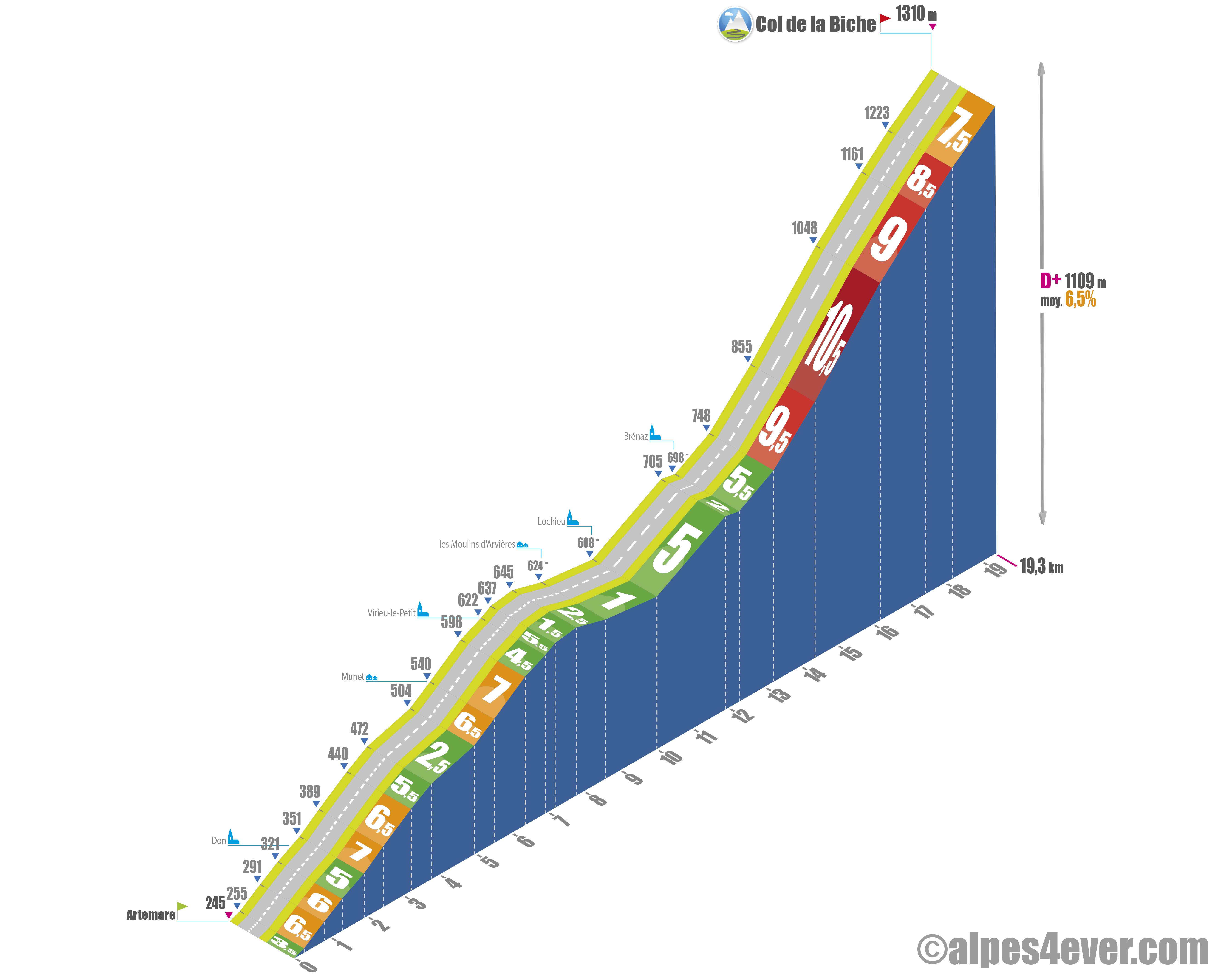
| Start | Artemare (260 m) | Distance | 20,5 km |
| Elevation | 1065 m | |
| Average gradient | 5% | Maximum gradient | 12% |
Climb time (rounded) of Col de la Biche by bike from Artemare (south-west side).ouest)
- At 7 km/h : 3h
- At 11 km/h : 1h 50'
- At 15 km/h : 1h 20'
- At 19 km/h: 1h 05'
Map of the route up the Col de la Biche by bike from Artemare (south-west side)
Map to be integrated via Drupal / Openrunner map module.
Description of the ascent of the Col de la Biche by bike from Artemare (south-west facing)
The ascent of the Col de la Biche from Artemare begins with a relatively easy section. The first few kilometers feature a moderate gradient, generally between 4 and 6%, with some variations. The climb then continues towards Brénaz, with a slightly irregular profile. The effort remains sustained but without any major difficulties up to this point, despite alternating more or less steep sections that make the pace unsteady.
From Brénaz, the profile changes markedly. The gradient becomes steeper, with sections above 10%. These sections follow one another over several kilometers, with no real recovery phase. The road gradually narrows, the surface can become rougher and the environment closes in, often in forest, with very little traffic.
The climb is characterized by this gradual progression in difficulty: an accessible start, followed by a more demanding second part, where the effort becomes continuous. The absence of long rolling sections and the succession of sustained sections make effort management essential.
The arrival at the summit comes after a climb that doesn't present any abrupt breaks, but which demands you steadily over the duration. More than 20 km nonetheless!
Tips for preparing the ascent of the Col de la Biche
The basic remark is the same as for the col du Grand Colombier. Even if the altitude remains very reasonable, the ascent of the Col de la Biche is difficult, especially from Gignez. Go well prepared and with suitable equipment.
Our advice:
- Adapt your effort. The average percentage may seem reasonable, but the climb is irregular, with frequent passages of over 10%.
- Anticipating isolation. The climb takes place in an environment with little traffic: no refuelling, little traffic, sometimes limited network. Be self-sufficient (water, food).
- Stay focused on the descent. The road is narrow, winding and sometimes rough, with possible gravel. Adapt your speed and keep margins, especially in the forest where visibility is reduced.
Weather conditions for the Col de la Biche
Like the Grand Colombier, the Biche is generally open from mid-April to November. Even if the summit is quite low, check the weather forecast before setting off and take at least one windbreaker with you.
Weather conditions on the Col de la Biche
Recommended equipment for the Col de la Biche
Same advice as for the Grand Colombier. A suitable gear ratio, a windproof jacket for the summit and the descent, two water bottles, bars or bananas in your pockets... And of course a repair kit, because if anything goes wrong, you could be very lonely on the slopes of the Biche.
Routes via the Col de la Biche
/
Services next to the Col de la Biche
No cafés or inns on the slopes or at the summit of the pass. On the other hand, all services at the start of the 2 slopes, especially on the Gignez side which is only a few kilometers from Seyssel.
Seyssel is a pleasant little town straddling two départements (01 and 74), on either side of the Rhône. It is located on the ViaRhôna.
Access to Col de la Biche
Rail access
- Culoz SNCF station (TER)
- Gare TGV de Bellegarde-sur-Valserine
Accès routiers
- Autoroute : A40 (Bellegarde exit) or A43 (Aix-les-Bains exit)
- D123
Those who have done it speak best of it!
FAQ
Is the Col de la Biche difficult?
Yes. Despite its moderate altitude, it's a very sporty climb. The slope from Gignez is more than 13 km long, with frequent climbs of over 10% and no real respite.
Which slope is the most difficult?
The slope from Gignez (or from Seyssel) is the most demanding. The one from Artemare is more gradual, but still long and irregular.
Why do cyclists appreciate this pass?
For its wild character: very little traffic, total immersion in nature and a rare feeling of isolation. It is often combined with the Grand Colombier to form a particularly demanding sequence.
What to see near the Col de la Biche?
The pass is part of a rich and accessible territory. In the immediate vicinity, Seyssel and the banks of the Rhône offer a great stop-off point, between heritage, river landscapes and gastronomic stops. This proximity makes it possible to combine the climb with a gentler discovery of the Upper Rhône.
Other passes near the Col de la Biche
Col du Grand Colombier
The giant of the Bugey and one of the most feared passes in France.
Les plus beaux cols de Route des Grandes Alpes ®
- Col de Joux-Plane
- Cormet de Roselend
- Col de la Loze
- Col de la Croix de Fer
- Col de la Madeleine
- Col de l'Iseran
- Alpe d'Huez ascent
- Col du Granon
- Col du Galibier
- Col de la Cayolle
- Col et Cime de la Bonette