

Col du Mont Cenis
From France to Italy
Altitude 2081 m
Massif du Mont-Cenis
Département Savoie
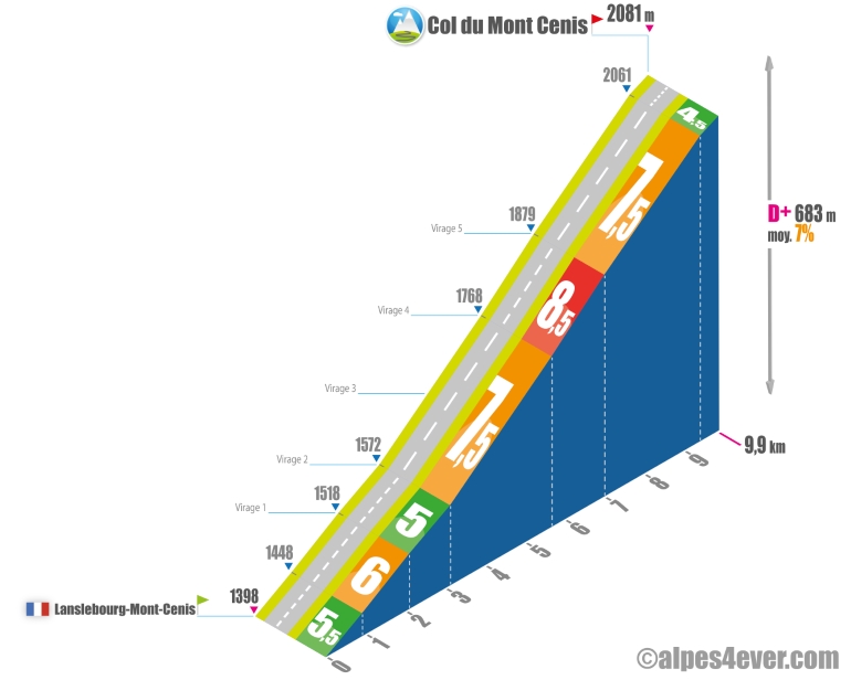
North side topo
The Col du Mont Cenis - 2081 m - leads from the Maurienne Valley in France to the Val di Susa in Italy.
The ascent starts at Lanslebourg-Mont-Cenis - alt. 1399 m (which is also the starting point for a prestigious ascent: the Col de l'Iseran). Expect a short ascent of 9.9 km at an average gradient of 7%. This last figure suggests a sustained gradient spread over 6 switchbacks, but one that is nevertheless fairly regular, with the most difficult section averaging no more than 8.5% over 1.3 km. You'll reach the Col du Mont Cenis at an altitude of 2081 m, but this doesn't mark the border with Italy, which lies 13 km further on the Italian side. As the ultimate reward for your effort, you'll have to go a few hectometres further to get a view of the superb Lac du Mont-Cenis nestling in the hollow of the Plateau du Mont-Cenis.
.
Please note: from the Col du Mont Cenis, you can take a round trip (7.7 km one way) to the Col du Petit Mont Cenis - 2183 m - on a narrow asphalt road that presents no major difficulties. This will be an opportunity to make a magnificent detour within the mountain and enjoy beautiful views of Lac du Mont-Cenis!
South side top
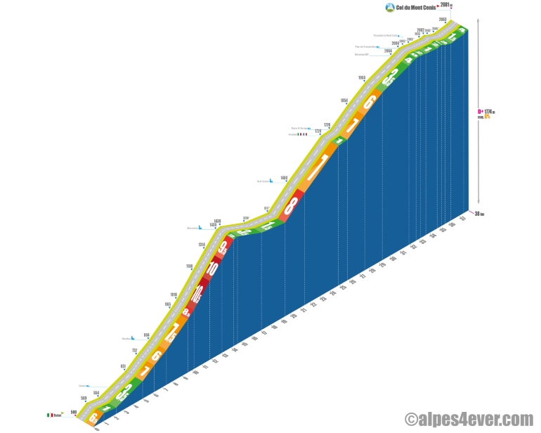
The Col du Mont Cenis - 2081 m - leads from Val de Susa in Italy to the Maurienne Valley in France.
The ascent starts at Susa (alt. 500 m) and will enable you to avoid much of the SS25 by taking the much quieter and picturesque "Strada Provinciale 210" via Novalesa. The climb will be longer, with 38 km and 1774 m of D+ at an average gradient of 6%, and the challenge will be even tougher, with 7 km to climb on an average gradient of 9% between Novalesa and Moncenisio. On this occasion, you'll be climbing an incredible series of 17 hairpin bends over 4.7 km on an average gradient of between 9.5 and 10.5%! Some of the hairpin bends are very short, with no flat spots...
.
Fortunately, a descent of almost 5 km will allow you to recharge your batteries. You'll be back on the SS25 below Bar Cenisio. There's another 18 km of ascent to the Col du Mont Cenis.
Count on a fairly steady gradient of around 8% for 2 km up to Bar Cenisio, then 3.4 km at 7% to the border.
It's only from the Col du Mont Cenis onwards that you'll be able to enjoy the best of both worlds.
It's not until you reach an altitude of 1720 m, just as you cross the Franco-Italian border, that the scenery comes into its own, with a series of twists and turns in front of you, followed by the Lac de Mont-Cenis dam a little higher up, and then the slope finally eases off with 8 km at an average gradient of 5% from the border to the Plan des Fontainettes, the highest point of the climb (alt. 2094 m).
From the Plan des Fontainettes to the pass, you'll have 5 km to complete on a succession of short ascents and descents all along the Lac de Mont-Cenis, which you can contemplate at your leisure.

Author
Joris Lesueur
webmaster of alpes4ever.com
contact@alpes4ever.com