


Above Alpe d'Huez
Altitude 1999 m
Massif des Grandes Rousses
Département Isère
West side topo
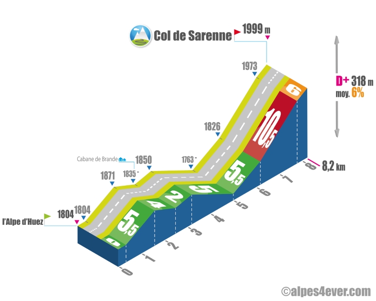
The start is at the Alpe d'Huez resort at the Europe traffic circle. Follow the road overlooking the resort's altiport and golf course. You'll then take the pastoral Col de Sarenne road, and the landscape will soon offer a beautiful natural environment. But the ascent is very uneven. The road climbs for 1.250 km at 5.5%. You then head due east on a gentle 900 m descent to the Cabane de Brande, followed by a 700 m climb on a false flat. Another 1.8 km downhill, then 1.2 km of positive gradient at 5.5%. You're thinking it's not too difficult up to this point... but after crossing a bridge over La Sarenne, you're faced with a terrible finale: a 1.6 km steep climb at... 10.5%. The last 450 metres at 6% will enable you to finish without flinching and reach the Col de Sarenne, which at 1999 m misses the symbolic "2000" mark by just 1 metre.
East side top
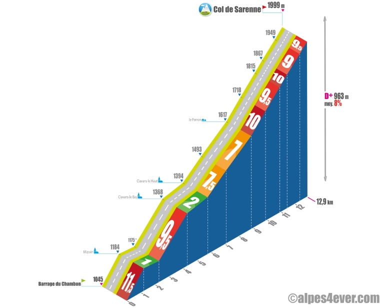
The Col de Sarenne - 1999 m - is a somewhat confidential pass. The reason: Alpe d'Huez, its close neighbor, totally overshadows it. Yet this quiet, pastoral route through a protected natural area is still relatively unspoilt. However, the 12.9 km ascent will still be tough with its 8% average gradient.
Take advantage of the beautiful view of the Lac de Chambon dam to prepare your gear. Without transition, you'll attack a terrible 1.2 km slope at 11.5%, fortunately spread over 3 switchbacks. After this intense mountaineering exercise, you'll plant your ice axe in Mizoën. A life-saving descent (1.1 km) takes you to the next part of the climb. There are 10.6 km and 824 m of ascent to climb. Apart from a refreshing 1.4 km flat at 2% between Clavans-le-Bas and Clavans-le-Haut, the last traces of human civilization, the gradient will hardly ever fall below an average of 7%, often rising to 9/10%. The last 4 km, spread over 10 hairpin bends on a gradient of between 9 and 10%, are Dantean! But you'll be able to enjoy a magnificent panorama of the Plateau d'Emparis and the peaks of the Massif des Écrins.
The map
The map
18 Variante L'Alpe d'Huez / Briançon
Author
Joris Lesueur
webmaster of alpes4ever.com
contact@alpes4ever.com