


The Petit Saint-Bernard pass
Between France and Italy
Altitude 2188 m
Massif des Alpes grées
Département Savoie
Versant Bourg-Saint-Maurice
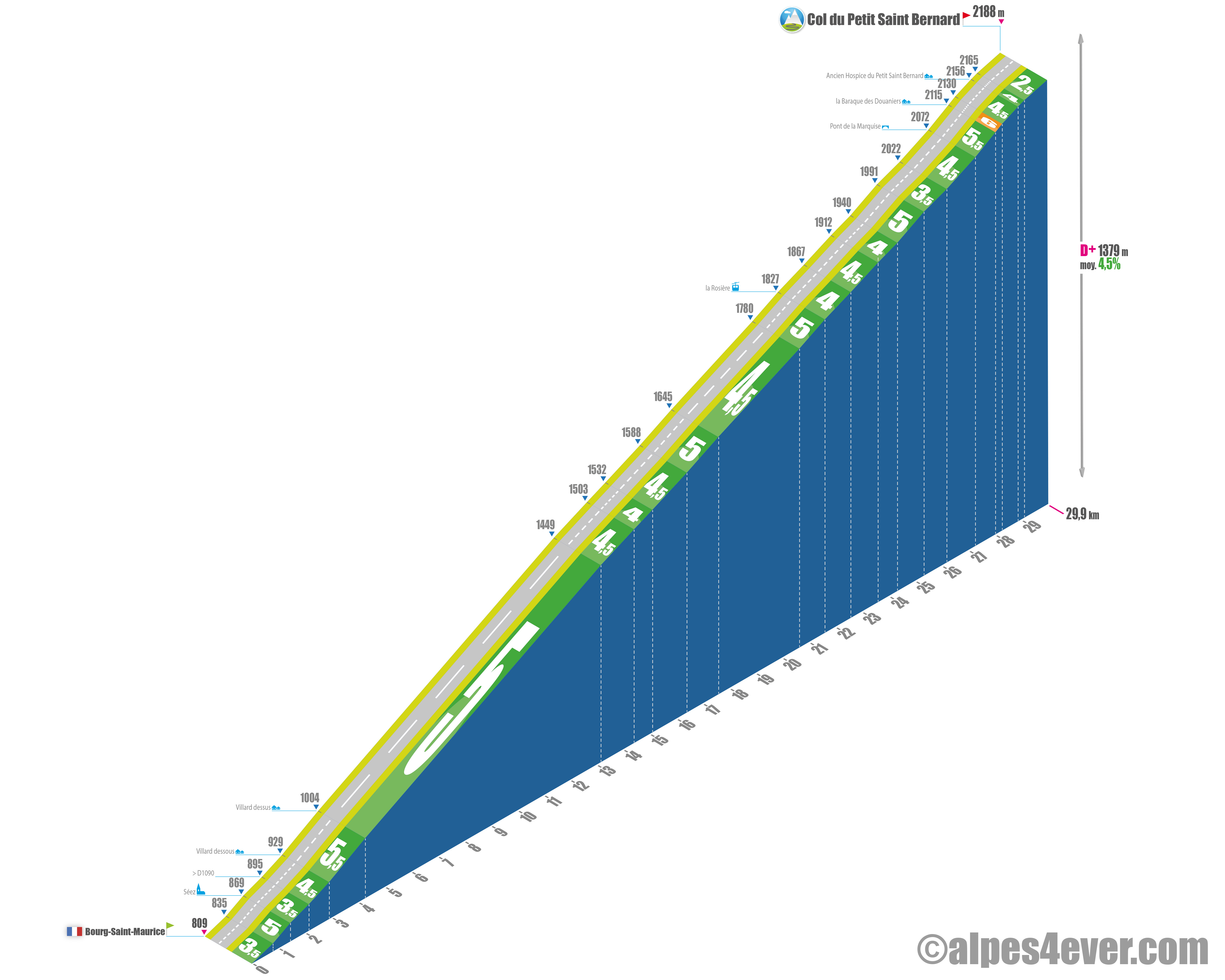
The Col du Petit Saint Bernard - 2188 m - is a border pass between France and Italy. It links the Tarentaise Valley (France) with the Val d'Aoste (Italy). At the top of this wide pass, you'll find the Hospice de Saint Bernard and its famous dog of the same name. Its southern slope offers a "relatively accessible" ascent for a "2,000", but be warned: it's a long one at nearly 30 km!
SOUTH FACE
From Bourg-Saint-Maurice, expect a long, long ascent of 29.9 km for 1379 m of D+ at an average of 4.5%! What makes it special is that the gradient is almost metronomically regular, spread out over twenty or so switchbacks! What's more, the gradients hardly ever exceed 6%, making this pass ideal for cyclists wishing to tackle their first "2000"!
.
As you leave Bourg-Saint-Maurice, you have to tackle a small ramp towards Séez, a small flat spot in the town and then head straight left, leaving the road on the right that leads to Europe's highest road pass: the Iseran, but that's a story for another day 😉
.
The road is very pleasant, winding between pastures and the pretty hamlets of Villard Dessous and Villard Dessus. The gradient is quite steep between the latter two, with 1.3 km at 5.5%. There's a fine view over Bourg-St-Maurice and the Séez basin.
The gradient softens and will hover around 5% average over the next 17 kilometers to the Station de la Rosière. There are plenty of vantage points along the ascent, which takes place both under forest cover and in the middle of pastures.
You arrive - finally - at the Station de la Rosière (alt. 1827 m) after a 21.5 km ascent from Bourg-St-Maurice. The resort is not very pretty
.
There are still 8.4 km to go, with some 360 m of ascent... and an altitude that will rise from 1800 to almost 2200 m, an important factor as the air becomes rarer...
.
On leaving La Rosière, the gradient is nothing too steep, between 4 and 4.5%. The road heads due north, and with a bit of luck, a tailwind will help you get ahead, but if not, it could become more difficult. In fact, there is no longer any shelter as the road winds its way up the long Vallon du Torrent du Reclus.
in a mineral setting.
Altitude 1940 m at PK24.3, the Col du Petit Saint Bernard is in sight and seems quite close, but everything is often deceptive in this situation. Take a look at your speedometer, there's still some 5.6 km to go. You can admire the Sommet des Rousses (2878 m) and the pointe de Lancebranlette (2936 m). The panorama is superb, a little marred by the huge electrified line linking Bourg-St-Maurice to Italy. A bird's-eye view of Bourg-St-Maurice... 1100 meters below!
On the final stretch, you wind your way up the hairpin bends - 250 m at 6% - around the former Hospice du Petit Saint Bernard and its statue. Then the road leads straight on to the pass, framed by the French-Italian customs posts. That's it, the Col du Petit Saint Bernard and its 2188 m are reached.
A nice photo to take next to a replica of the famous Saint Bernard, this magnificent dog, mascot of mountain dwellers with a barrel of schnapps hanging around his neck.

Author
Joris Lesueur
webmaster of alpes4ever.com
contact@alpes4ever.com