


Cucheron pass
In the heart of the Chartreuse
Altitude 1139 m
Massif de la Chartreuse
Département Savoie
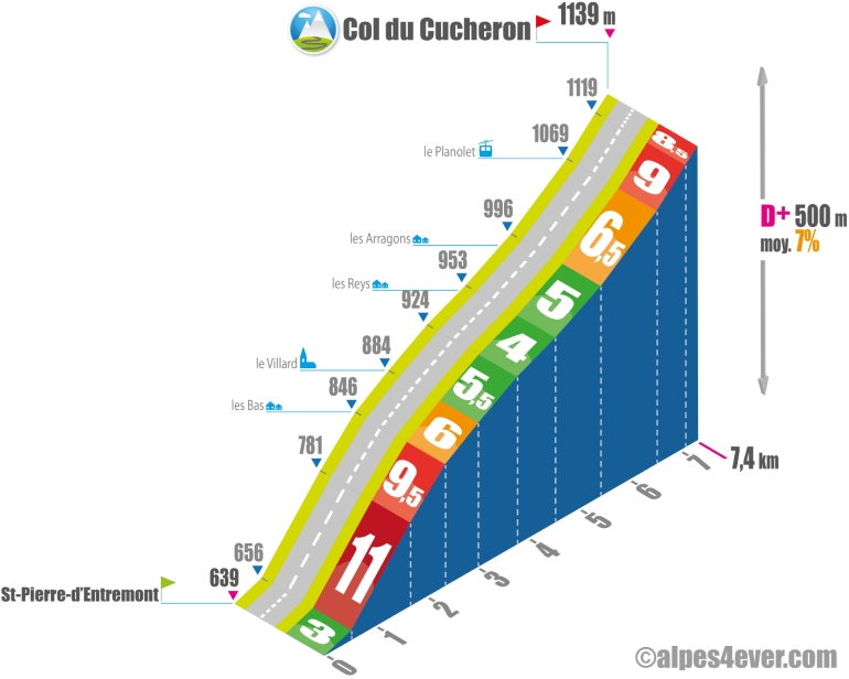
Topo North side
The Col du Cucheron - 1139 m - is located right in the center of the magnificent Chartreuse Massif. Its modest altitude conceals a rather rugged ascent.
The starting point for the northern slope is St-Pierre-d'Entremont. This village is cut in 2 by the Torrent du Guiers, which forms the border with Savoie! So there's a St-Pierre-d'Entremont (Savoie) and a St-Pierre-d'Entremont (Isère), and they're 2 different communes! However, as you leave St-Pierre-d'Entremont, the road splits into 2 variants: you can choose to go via St-Philibert (D512) or Les Reys (D102b), the latter being the route taken by the Petites Routes du Soleil. These 2 variants meet up at the small ski resort of Le Planolet, just below the Col du Cucheron
.
The route via Les Reys is 7.4 km at an average gradient of 7%. The first 2,400 m are tough, with 1150 m at 11% followed by 700 m at 9.5%. On the first hairpin bends, take in the beautiful views of the Chartreuse Massif's characteristic peaks, such as Rochers de Fouda Blanc, Mont Granier and Roche Veyrand. From Le Villard onwards, you'll find it easier to manage your climb. The slope picks up again on the outskirts of the Station du Planolet (1.1 km at 6.5%). There's one last bit of ass left - 800 m at almost 9% - to pull you up to the Col du Cucheron.
South side top
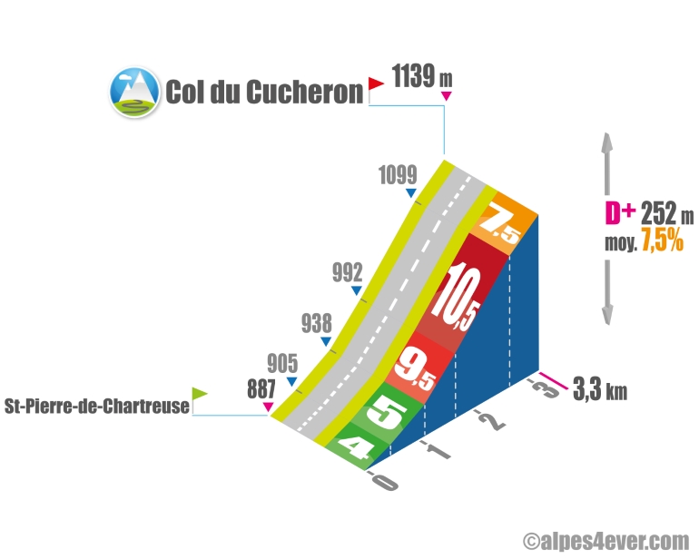
Attentive, the Petites Routes du Soleil itinerary offers you a short, bucolic detour via St-Hugues-de-Chartreuse and without difficulty to reach Saint-Pierre-de-Chartreuse indirectly (you won't have to go all the way down to La Diat).
.
Short at just 3.3 km, the climb will be intense: 7.5% average with an intense passage in the upper part of 1.6 km at 10% average

Author
Joris Lesueur
webmaster of alpes4ever.com
contact@alpes4ever.com