
Altitude 2247 m
Massifs du Pelat / des Trois-Évêchés
Département Alpes-de-Haute-Provence
The Col d'Allos rises to 2247 m and links the Ubaye Valley to the north with the Verdon Valley to the south. Opened in 1891, the pass road is already over 100 years old!
Despite its altitude, the ascent - on both sides - is not very difficult, as there are no steep gradients. Above all, you need to manage your effort over the distance, more or less 20 km all the same, on a good day, this pass is real happiness.
North side
Distance 19.5 km
Start Barcelonnette (Ubaye Valley)
D+ 1123 m
% average 6%
max % 9% over 600 m

Once again, here's my account of his ascent, which I did in August 2010...
Saturday, August 8, 2010 - Early start this morning... the weather is gorgeous but, exceptionally, the temperature is around 5°C! This adds a little spice to the climb up to the 2247 m pass. No need to warm up, the first ramp up the pass begins as soon as you leave the Tampico campsite
.
After 2.5 km, at the Col d'Allos / Pra-Loup crossroads, the barriers prohibiting access by motorized vehicles are firmly in place and dozens and dozens of cyclos are entering the only authorized passage. I'm going to take advantage of a great opportunity: with the "cols réservés aux cyclistes" operation, some legendary cols are open only to bikes, free of charge, with no timing or ranking, no registration and no set start time. The only constraint is that the road is reserved from 8am to 11am (for info: https://www.tourisme-alpes-haute-provence.com/cols-a-velo/).
The atmosphere is incredible, and everyone is happy to take advantage of the opportunity.
I'm euphoric and can barely feel the slope, which hovers at 7/8%. It's unbelievable, there are all kinds of cyclists: young and old, strong riders going fast, diesels like me well set in their rhythm, less experienced riders already starting to suffer... we're in the first 5 km, there's still 17 to go!
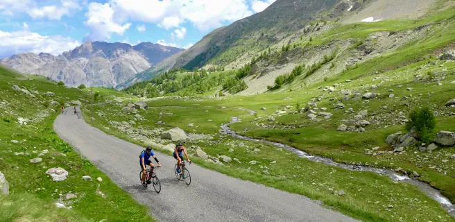
In the meantime, the road rises again, overlooking the "Gorges du Bachelard". The scenery is magnificent, and the first ramps of the Col de la Cayolle can be seen to the east. A vertiginous ravine stands to the right and the rock face rises just to the left, the road is quite narrow: it's one hell of a mountain road!
.
A huge advantage of the absence of motorized vehicles: you can cut corners and relax a little to enjoy the panorama. The presence of a large number of cyclists also means that the slower climbers can be "jumped", giving the ascent a lively pace. The legs are spinning like hell!
The road veers off to the right to follow another valley marked by the torrent des Agneliers, which is hard to make out at the far end of the ravine. But the gradient is much less steep - 4/4.5% - and allows you to pass a few more gables.
After passing the small "Agneliers" station (alt. 1730 m), there's another break in the slope and we enter a more forested section. Remarkably, you can see the road you've already climbed on the other side of the valley: it's below you and looks tiny, so you realize what a huge climb you're on!
Already 12.5 km into the climb, the gradient becomes steeper, with a pretty yawing section at 9%. After 2 km, the road twists and turns through pastures. The scenery is breathtaking, and as you ascend these twists and turns, you can see dozens of cyclists at the top and bottom, giving you a good idea of the difference in altitude (approx. 175 m in 3 km).
.
I pick up the pace on a 6/6.5% section. There's still 2 km to go. The end of the pass is pure bliss as the gradient - despite some 8% sections - is very rolling.
3 particular points caught my attention for the last 2 km of this pass at over 2000 m:
an easy finish
- an easy finish
- a non-mineral landscape, more like alpine pastures,
and
- the pass is not in sight, but is discovered at the last moment in a right-hand bend.
With the "Petit Cheval de Bois" (2754 m) and the "Grand Cheval de Bois" (2838 m) in the background, the Col d'Allos is crossed at 2247 m.
Happy, happy, happy!
Happy, happy, happy, because I was having a good day! This pass is truly magnificent and I've decided to include it in my top 10 of the most beautiful passes I've ever climbed. It's still cool out, but I take my time, chat with other cyclists (everyone arrives one by one or in groups of 2 or 3, others start to descend, it's a pretty sight), relax a little on the heights, admire these mountains always grandiose. I take a look at the last hairpin bends on the southern slope... just how I'd like to do it! Come on, it'll be for... a few days later!
SOUTHER SIDE
Distance 22.6 km
Start Colmars (Verdon Valley)
D+ 1010 m
average % 4,5%
max % 7,5% on 785 m and 1,1 km

This side is less wild than the north side. From Colmars, a pretty little medieval village, the ascent is 22.6 km long. It can be divided into 3 parts:
The ascent begins with a long 9.2 km false flat through Allos. While skirting the Verdon river, you'll encounter no difficulties (between 0.5 and 4.5%) on this fairly wide, almost straight road.
After Allos, the gradient changes to a downhill slope.
After Allos, the gradient becomes more insistent up to La Foux d'Allos, with 6.9 km at an average gradient of 5%. The Verdon valley narrows.
You arrive at La Foux d'Allos, quickly cross the resort and, as you leave it, discover the hors-d'oeuvre of this climb: 13 magnificent switchbacks spread over almost 6.5 km at an average gradient of 7%. The scenery is breathtaking, and hardly spoiled by the resort's few ski lifts.
The map
The map
22 Barcelonnette / Valberg
Author
Joris Lesueur
webmaster of alpes4ever.com
contact@alpes4ever.com
06 81 38 77 26
1, allée des Chênes
21910 Corcelles-lès-Cîteaux