

Col de l'Échelle
A first on the Route des Grandes Alpes®.
Altitude 1762 m
Massif des Cerces
Piedmont region (Italy)
Topo North slope

The Col de l'Échelle - 1762 m - is a pass (located on French territory) that links France and Italy. Hidden anonymously between the Clarée and Bardonecchia valleys, it's a better, quieter alternative to the Col de Montgenèvre. Its respectable altitude might not suggest an easy climb, but this is not the case, as the following description shows.
From Bardonecchia in Italy (at the exit of the Fréjus Tunnel), the ascent is irregular. The first 1500 meters are fairly easy, with an average gradient of 2%. You'll work up a sweat on a slope that steepens to between 5.5% and 6.5% for 1400 m as far as Melezet. A flat area followed by a short descent will allow you to tackle the next part of the climb more calmly: 1.1 km at 6.5% to Pian del Colle. Then a gentle slope of 900 m at 3.5% takes you to the old border post. From here, the most difficult part of the climb begins: 4.3 km on an average gradient of between 6 and 8.5%, divided into a succession of 6 switchbacks. At the tenth kilometer, you'll reach the highest point on this slope at 1779 m altitude, and cross an intermediate pass, the Mauvais Pas. A short descent, followed by a slight false flat rise, will bring you to the Col de l'Echelle at 1762 m.
.
South side topo
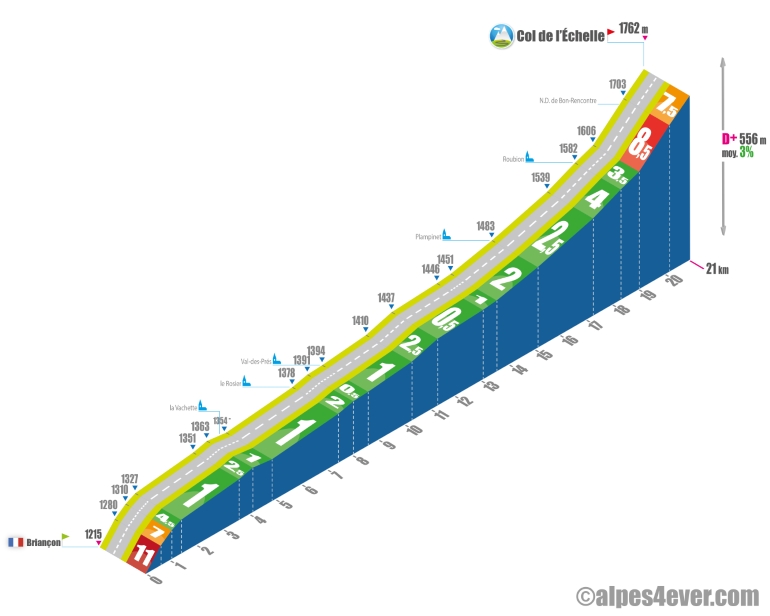
The Col de l'Échelle - 1762 m - is a pass (located on French territory) that links France and Italy. Hidden anonymously between the Clarée and Bardonecchia valleys, it's a better, quieter alternative to the Col de Montgenèvre.
From Briançon, where you'll have to extricate yourself via a good 600 m ramp at 11%, it's a 21 km climb up the Vallée de la Clarée - very easy with only one passage at 4% max - until just before Névache where the hardest part of the pass begins with 2 km at almost 8% average.
