
Col des Champs
High Verdon Trilogy
Altitude 2087 m
Massif du Pelat
Département Alpes-Maritimes
The Col des Champs lies at an altitude of 2,045 m, on the border between the Alpes-de-Haute-Provence and Alpes-Maritimes departments, but the road pass culminates at 2,087 m. Wild and beautiful, it links the Var (to the east) and Verdon (to the west) valleys. The particularity of this pass is that it is very wide, as it is a vast mountain pasture dominated by the Dent du Lièvre (alt. 2667 m). Oh, I forgot something... the climbs are very tough on both sides of the pass!
...WESTERN SIDE
Distance 11.5 km
Start Colmars (Verdon Valley)
D+ 831 m
average % 7,5%
max % 10% on 675 m

Starting from Colmars, the climb is shorter at 11.5 km but a little more intense with 831 m of D+ at an average of 7.5%. The first part of the climb is a series of 10 switchbacks, some of which are very tight. Steady gradient that hardly drops below 7.5% apart from a 550 m flat at 2% at Chalet de Ratery on the 5th kilometer.
.
Until summer 2018, the road was of poor quality, but it was resurfaced from km 2 to the summit. It's now a brand-new surface with superb performance (although beware of the multiple rainwater drainage trenches in the section near the summit). Almost the entire ascent is made under impressive forest cover (mélézin) on a very narrow road (be careful if you pass a vehicle).
But the finale is splendid when you reach the top.
But the finale is splendid as you emerge from the forest into an almost mineral landscape on the slopes of Montagne de Noncière.
Just like the other side of the valley, the valley's slopes are also very steep.
As on the other side of the mountain, the final 600 meters are gentle, ending with a slight descent.
This pass is often crossed by cyclists on the legendary Cayolle > Champs > Allos or Allos > Champs > Cayolle loop from Barcelonnette. Count on 117 km and 3200 m of D+!
EAST SLOPE
Distance 16.3 km
Start Saint-Martin-d'Entraunes (Vallée du Var)
D+ 1069 m
% average 7%
% max 10% over 900 m
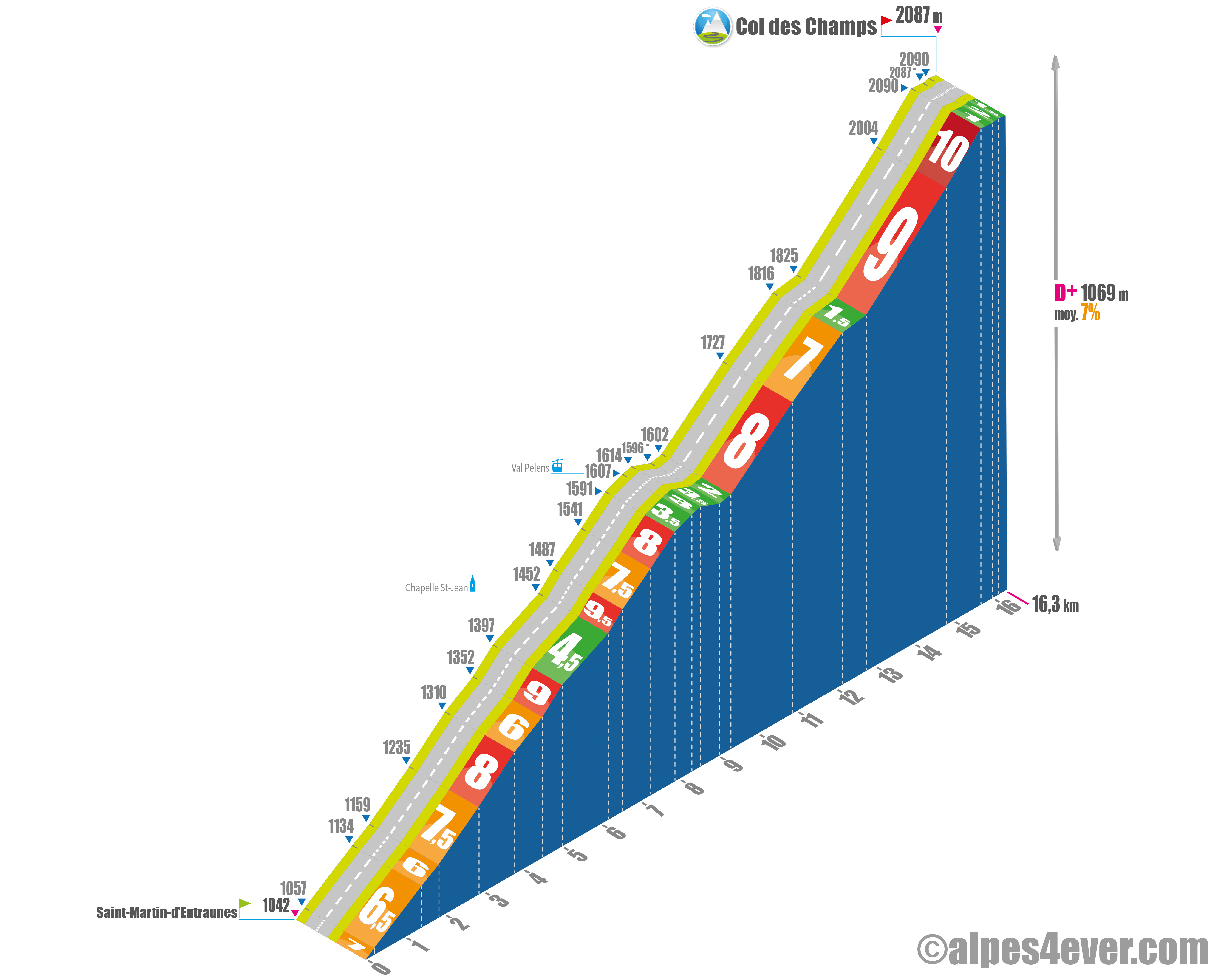
The Alpes-Maritimes side, which starts at Saint-Martin-d'Entraunes, is almost 16 km long for 1069 m of D+ at 7% average. The surface is of good quality.
The climb begins on the D78 and then the D278 over a series of 12 switchbacks: 6.2 km at 6.5% with a gradient of between 6 and 9%, but the last 1,200 m at 4.5% will give you a breather
.
From Chapelle Saint-Jean (Alt. 1,452 m), the gradient rises to an average of 9.5% for around 400 m, and you're glued to the road, especially as it's hard going all the way to Val Pelens, with 1.3 km at an average gradient of 8%.
.
With almost half the climb in your calves, you pass through the pretty little resort of Val Pelens (Alt.1,607 m). Make the most of it, it's a lovely 1.4 km flat spot.
After crossing a small bridge over the Ruisseau de Chastelonette, the slope picks up again, averaging 7.5% for the next 2.8 km. Regular but exhausting!
At the end of this stretch, the road makes a small loop that offers you both a breathtaking, magnificent view of the Var Valley and a 600 m, 1.5% gradient flat that you welcome with relief. Make the most of it, because you're in for a terrific finale!
The last part of the climb takes place in the middle of alpine pastures, with the Cime de la Voya in the background. The gradient is tough: between 9 and 10% average for almost 2.9 km.
After the Cabane de Voya, the gradient rises to 14% for several meters.
At an altitude of over 2,000 m, the effort is great, the breath is short... and then the slope eases. After reaching the highest point of this ascent - 2,090 m - you'll reach the Col des Champs 650 m further on, on a gentle descent to 2,087 m.
The Col des Champs sign is on the right side of the road.
The sign for the Col is on the Alpes-Maritimes side. There are no restaurants or other facilities at the summit, just a parking lot and a commemorative stele. One of the few passes over 2,000 m not polluted by tourism! It's easy to see the geographical pass a little lower down in the middle of the mountain pastures, but the track is quite rocky and not very accessible by road bike.
