


Col de Porte
Magnificent view of Chamechaude
Altitude 1326 m
Massif de la Chartreuse
Département Savoie
Topo North side
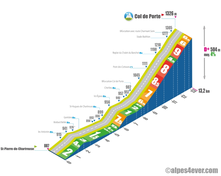
The Col de Porte - 1326 m - lies to the south of the magnificent Chartreuse Massif. Its modest altitude conceals a not-so-easy ascent of its northern side.
Please note that the Petites Routes du Soleil itinerary offers a short, easy detour to St-Hugues-de-Chartreuse. On the descent from the Col du Cucheron, don't go all the way down to the bottom of St-Pierre-de-Chartreuse, but take the Route de Perquelin just past the Post Office.
From St-Hugues-de-Chartreuse, take the Route de Perquelin, just past the Post Office.
From St-Hugues-de-Chartreuse, in a pretty country setting, the road picks up again for 1 km, rising from 5% to 7%. Take advantage of the flat area after the small hamlet of Les Égaux to regain your strength and attack the final stretch, which takes place in a wooded environment, with 5 km at an average gradient of almost 7.5%, with a fairly tough section from 1.7% to over 8% average before the Pont des Cottaves to the flat area of the Chalet de Banchet, which saves the day a little.
You'll still have to climb 735 m at a depressing 9% to the Biathlon Stadium. At the junction with the Chalets de Charmant Som road, a "false" Col de Porte sign doesn't quite signal the end, as you have to climb another 335 m at 6.5% to the true summit of the pass, at 1326 m.
At the top, you'll enjoy a magnificent view of the valley.
At the summit, a magnificent view of Chamechaude awaits you.
South side top
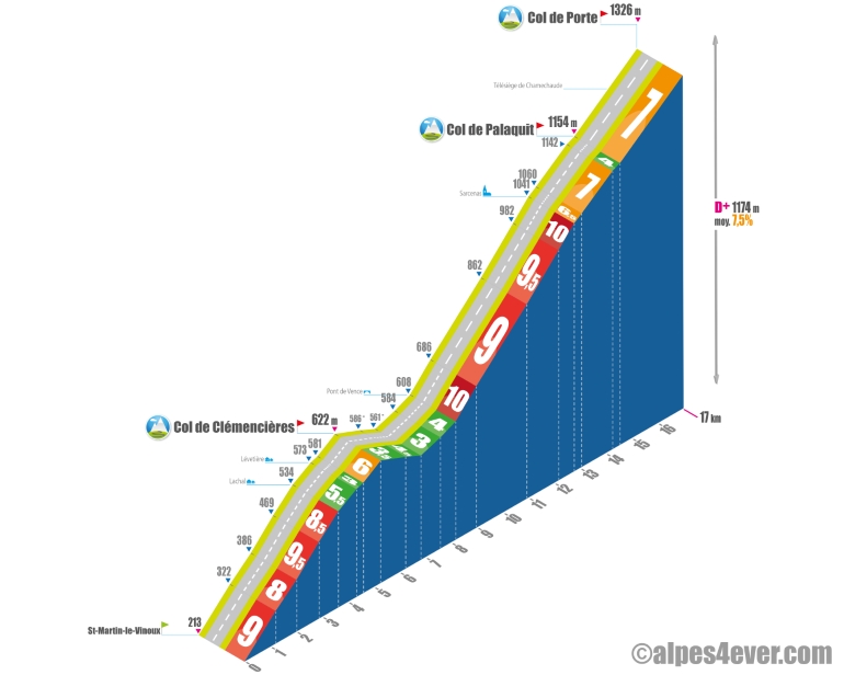
Starting from St-Martin-le-Vinoux (a town north-west of Grenoble), a long and difficult climb awaits you, with 16.9 km at an average of 7.5%!
First, you'll climb a terrible ramp - 5.3 km at an average gradient of 8% - to the Col de Clémencières (alt. 622 m).
Then it's time to get back into the swing of things: a leisurely descent and ascent to Pont de Vence.
Then climb a wall - 4.6 km at 9.5% to Sarcenas... Hard!
Things settle down a little until the Col de Palaquit (alt. 1154 m) with 1.8 km at an average of 6.5%.
The finale will finish you off: 2.5 km at almost 7% average up to the Col de Porte!

Author
Joris Lesueur
webmaster of alpes4ever.com
contact@alpes4ever.com